চিত্র:Lake Athabasca, Canada.jpg

এই প্রাকদর্শনের আকার: ৮০০ × ৩৩৮ পিক্সেল। অন্যান্য আকারসমূহ: ৩২০ × ১৩৫ পিক্সেল | ৬৪০ × ২৭০ পিক্সেল | ১,১৫৬ × ৪৮৮ পিক্সেল।
পূর্ণ রেজোলিউশন (১,১৫৬ × ৪৮৮ পিক্সেল, ফাইলের আকার: ১৭৩ কিলোবাইট, এমআইএমই ধরন: image/jpeg)
| এই ফাইলটি উইকিমিডিয়া কমন্স থেকে নেওয়া। সেখানের বর্ণনা পাতার বিস্তারিত নিম্নে দেখানো হলো। (সম্পাদনা)
|
সারাংশ
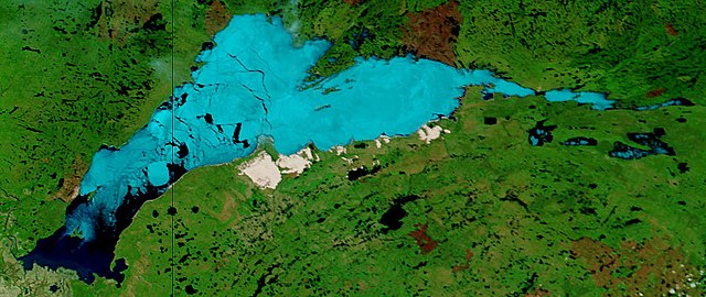
| বিবরণ | Lake Athabasca, Canada. Lake Athabasca straddles the border between Alberta (west) and Saskatchewan (east) - the black line. In the false-color image, vegetation is green, water is dark blue, and ice (or snow) is light blue. |
| তারিখ | Visualization Date: 2002-06-18 |
| উৎস | Visible Earth, NASA (extract) |
| লেখক | Jacques Descloitres, MODIS Land Rapid Response Team, NASA/GSFC |
Cropped from the original 4800 x 3600 JPEG (4.4MB) image.
লাইসেন্স প্রদান
| এই ফাইলটি পাবলিক ডোমেইনে আছে কারণ এটি শুধুমাত্র নাসা কর্তৃক নির্মিত হয়েছিল। নাসার কপিরাইট নীতি হচ্ছে যে "নাসা কর্তৃক উল্লেখ না থাকলে নাসার উপাদান কপিরাইট দ্বারা সুরক্ষিত নয়"। (Template:PD-USGov, নাসার কপিরাইট নীতির পাতা অথবা জেপিএল চিত্র ব্যবহারের নীতি দেখুন।) | ||
 |
সতর্কবার্তা:
|
ফাইলের ইতিহাস
যেকোনো তারিখ/সময়ে ক্লিক করে দেখুন ফাইলটি তখন কী অবস্থায় ছিল।
| তারিখ/সময় | সংক্ষেপচিত্র | মাত্রা | ব্যবহারকারী | মন্তব্য | |
|---|---|---|---|---|---|
| বর্তমান | ১১:৩৭, ১৮ আগস্ট ২০০৬ | | ১,১৫৬ × ৪৮৮ (১৭৩ কিলোবাইট) | Feydey | {{Information |Description= Lake Athabasca, Canada. Lake Athabasca straddles the border between Alberta (west) and Saskatchewan (east) - the black line. In the false-color image, vegetation is green, water is dark blue, and ice (or snow) is light blue. |S |
সংযোগসমূহ
নিচের পৃষ্ঠা(গুলো) থেকে এই ছবিতে সংযোগ আছে:
ফাইলের বৈশ্বিক ব্যবহার
নিচের অন্যান্য উইকিগুলো এই ফাইলটি ব্যবহার করে:
- af.wikipedia.org-এ ব্যবহার
- ar.wikipedia.org-এ ব্যবহার
- arz.wikipedia.org-এ ব্যবহার
- be.wikipedia.org-এ ব্যবহার
- bg.wikipedia.org-এ ব্যবহার
- bs.wikipedia.org-এ ব্যবহার
- ca.wikipedia.org-এ ব্যবহার
- ceb.wikipedia.org-এ ব্যবহার
- cv.wikipedia.org-এ ব্যবহার
- cy.wikipedia.org-এ ব্যবহার
- da.wikipedia.org-এ ব্যবহার
- el.wikipedia.org-এ ব্যবহার
- en.wikipedia.org-এ ব্যবহার
- eo.wikipedia.org-এ ব্যবহার
- es.wikipedia.org-এ ব্যবহার
- eu.wikipedia.org-এ ব্যবহার
- fa.wikipedia.org-এ ব্যবহার
- frr.wikipedia.org-এ ব্যবহার
- fr.wikipedia.org-এ ব্যবহার
- fy.wikipedia.org-এ ব্যবহার
- hu.wikipedia.org-এ ব্যবহার
- hy.wikipedia.org-এ ব্যবহার
- id.wikipedia.org-এ ব্যবহার
- incubator.wikimedia.org-এ ব্যবহার
- it.wikipedia.org-এ ব্যবহার
- ka.wikipedia.org-এ ব্যবহার
- kk.wikipedia.org-এ ব্যবহার
- ky.wikipedia.org-এ ব্যবহার
- lt.wikipedia.org-এ ব্যবহার
- lv.wikipedia.org-এ ব্যবহার
- nl.wikipedia.org-এ ব্যবহার
- no.wikipedia.org-এ ব্যবহার
- pl.wikipedia.org-এ ব্যবহার
- pl.wiktionary.org-এ ব্যবহার
- pnb.wikipedia.org-এ ব্যবহার
- pt.wikipedia.org-এ ব্যবহার
- ro.wikipedia.org-এ ব্যবহার
- ru.wikipedia.org-এ ব্যবহার
- sv.wikipedia.org-এ ব্যবহার
- te.wikipedia.org-এ ব্যবহার
- tg.wikipedia.org-এ ব্যবহার
- uk.wikipedia.org-এ ব্যবহার
- ur.wikipedia.org-এ ব্যবহার
- uz.wikipedia.org-এ ব্যবহার
এই ফাইলের অন্যান্য বৈশ্বিক ব্যবহার দেখুন।