চিত্র:ImperioOtomano1683.png
এর চেয়ে বেশি রেজোলিউশন লভ্য নয়।
ImperioOtomano1683.png (৭৪৯ × ৬০০ পিক্সেল, ফাইলের আকার: ৯৭ কিলোবাইট, এমআইএমই ধরন: image/png)
| এই ফাইলটি উইকিমিডিয়া কমন্স থেকে নেওয়া। সেখানের বর্ণনা পাতার বিস্তারিত নিম্নে দেখানো হলো। (সম্পাদনা)
|

|
This map image could be re-created using vector graphics as an SVG file. This has several advantages; see Commons:Media for cleanup for more information. If an SVG form of this image is available, please upload it and afterwards replace this template with
{{vector version available|new image name}}.
It is recommended to name the SVG file “ImperioOtomano1683.svg”—then the template Vector version available (or Vva) does not need the new image name parameter. |
সারাংশ
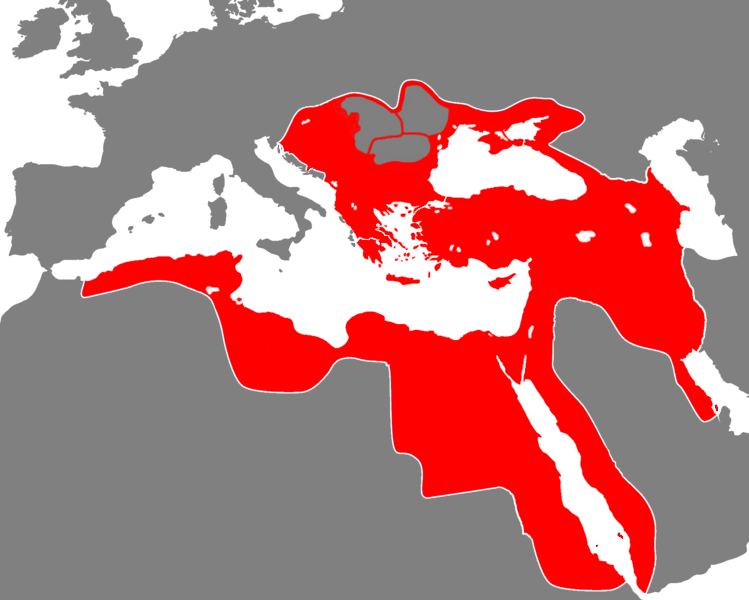
| বিবরণ | The Ottoman Empire during the 17th century |
| তারিখ | 5/7/2007 |
| উৎস | |
| লেখক | viejoverde |

লাইসেন্স প্রদান
| এই কাজের প্রণেতা I, Viejoverde কাজটি পাবলিক ডোমেইনে প্রকাশ করেছেন। এটি বিশ্বব্যাপী প্রযোজ্য হবে। কিছু দেশে এটি আইনত সিদ্ধ নাও হতে পারে, যদি তাই হয়: I, Viejoverde যে-কাউকে যেকোনো উদ্দেশ্যে, বিনাশর্তে এই কাজটি ব্যবহারের অনুমতি প্রদান করেন, যদি না সেই শর্তগুলো আইনত প্রয়োজনীয় হয়। |
ফাইলের ইতিহাস
যেকোনো তারিখ/সময়ে ক্লিক করে দেখুন ফাইলটি তখন কী অবস্থায় ছিল।
| তারিখ/সময় | সংক্ষেপচিত্র | মাত্রা | ব্যবহারকারী | মন্তব্য | |
|---|---|---|---|---|---|
| বর্তমান | ১৩:০৯, ১ জুলাই ২০১৪ | | ৭৪৯ × ৬০০ (৯৭ কিলোবাইট) | MetrouFan | Reverted to version as of 21:57, 1 October 2013 This version is more accurate. |
| ২১:৩০, ৫ অক্টোবর ২০১৩ |  | ১,৬৮৪ × ১,৩৪৮ (১১৮ কিলোবাইট) | Underlying lk | this image is used on several articles, upload your image under a different name. | |
| ২১:৫৭, ১ অক্টোবর ২০১৩ |  | ৭৪৯ × ৬০০ (৯৭ কিলোবাইট) | Spiridon Ion Cepleanu | Corrected since H.E. Stier (dir.) Grosser Atlas zur Weltgeschichte, Westermann 1985, ISBN 3-14-10-0919-8, pp. 71-119 and other atlases : christian principalities - vassals but not provinces of the Ottoman Sultanate : in grey marked out with red ; Ethio... | |
| ১৮:৩৭, ১০ মার্চ ২০১০ |  | ১,৬৮৪ × ১,৩৪৮ (১১৮ কিলোবাইট) | Rülpsmann | fixed Pelopponese | |
| ১৯:১১, ৯ মার্চ ২০১০ |  | ১,৬৮৪ × ১,৩৪৮ (১১৮ কিলোবাইট) | Rülpsmann | fixed colours (of the islands) | |
| ২১:১২, ২৪ জানুয়ারি ২০১০ |  | ১,৬৮৪ × ১,৩৪৮ (১১৮ কিলোবাইট) | Rülpsmann | Reverted to version as of 13:38, 24 January 2010: This was 1683! Read a history book or look at the other images about Turkey! | |
| ১৮:৩৪, ২৪ জানুয়ারি ২০১০ |  | ৭৪৯ × ৬০০ (৮৮ কিলোবাইট) | Persia2099 | Reverted to version as of 23:30, 23 January 2010 | |
| ১৩:৩৮, ২৪ জানুয়ারি ২০১০ |  | ১,৬৮৪ × ১,৩৪৮ (১১৮ কিলোবাইট) | AteshCommons | Reverted to version as of 15:47, 11 December 2009 | |
| ২৩:৩০, ২৩ জানুয়ারি ২০১০ |  | ৭৪৯ × ৬০০ (৮৮ কিলোবাইট) | Persia2099 | crrect(eastern borders) | |
| ১৫:৪৭, ১১ ডিসেম্বর ২০০৯ |  | ১,৬৮৪ × ১,৩৪৮ (১১৮ কিলোবাইট) | Rülpsmann | corrected (East africa, azerbaijan) |
সংযোগসমূহ
নিচের পৃষ্ঠা(গুলো) থেকে এই ছবিতে সংযোগ আছে:
ফাইলের বৈশ্বিক ব্যবহার
নিচের অন্যান্য উইকিগুলো এই ফাইলটি ব্যবহার করে:
- af.wikipedia.org-এ ব্যবহার
- ar.wikipedia.org-এ ব্যবহার
- قائمة الخلفاء
- محمد الرابع (عثماني)
- الممالك في إفريقيا قبل الاستعمار
- بوابة:الإسلام/دولة مختارة
- بوابة:الإسلام/دولة مختارة/4
- مستخدم:باحث
- بوابة:التاريخ الإسلامي/دولة مختارة/أرشيف
- بوابة:التاريخ الإسلامي/دولة مختارة/1
- بوابة:العالم الإسلامي
- قالب:مواضيع متعلقة 3
- قالب:مواضيع متعلقة 3/شرح
- بوابة:العالم الإسلامي/تاريخ
- بوابة:العالم الإسلامي/مواضيع متعلقة
- شجرة العائلة العثمانية
- ca.wikipedia.org-এ ব্যবহার
- da.wikipedia.org-এ ব্যবহার
- de.wikipedia.org-এ ব্যবহার
- en.wikipedia.org-এ ব্যবহার
- es.wikipedia.org-এ ব্যবহার
- fr.wikipedia.org-এ ব্যবহার
- fr.wiktionary.org-এ ব্যবহার
- hr.wikipedia.org-এ ব্যবহার
- hy.wikipedia.org-এ ব্যবহার
- id.wikipedia.org-এ ব্যবহার
- it.wikipedia.org-এ ব্যবহার
- ja.wikipedia.org-এ ব্যবহার
- ja.wiktionary.org-এ ব্যবহার
- pl.wikipedia.org-এ ব্যবহার
- pl.wiktionary.org-এ ব্যবহার
- pt.wikipedia.org-এ ব্যবহার
- ro.wikipedia.org-এ ব্যবহার
- sh.wikipedia.org-এ ব্যবহার
- tr.wikipedia.org-এ ব্যবহার
- zh.wikipedia.org-এ ব্যবহার