উত্তর আয়ারল্যান্ড
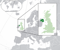
উত্তর আয়ারল্যান্ড (আইরিশ: Tuaisceart Éireann [ˈt̪ˠuəʃcəɾˠt̪ˠ ˈeːɾʲən̪ˠ] ();[৮] আলস্টার-স্কট্স: Norlin Airlann) যুক্তরাজ্যের অন্তর্গত একটি দেশ, প্রদেশ বা অঞ্চল।[৯][১০][১১][১২][১৩] আয়ারল্যান্ড দ্বীপের উত্তর-পূর্বে অবস্থিত এই অঞ্চলটির দক্ষিণ ও পশ্চিমদিকে আয়ারল্যান্ড প্রজাতন্ত্রের সঙ্গে সীমান্ত রয়েছে। ২০১১ সালে এর জনসংখ্যা ছিল ১,৮১০,৮৬৩,[৪] যা দ্বীপটির মোট জনসংখ্যার ৩০% এবং যুক্তরাজ্যের মোট জনসংখ্যার ৩%। গুড ফ্রাইডে চুক্তির অংশ হিসেবে উত্তর আয়ারল্যান্ড আইন ১৯৯৮ দ্বারা প্রতিষ্ঠিত উত্তর আয়ারল্যান্ড আইনসভা (যা স্টরমন্ট হিসেবে পরিচিত) উন্নয়ন নীতিনির্ধারণ সংক্রান্ত বিষয়াবলির দায়িত্ব পালন করে, এছাড়া অন্যান্য ক্ষেত্র ব্রিটিশ সরকারের নিয়ন্ত্রণে থাকে। উত্তর আয়ারল্যান্ড প্রজাতন্ত্রী আয়ারল্যান্ডের সঙ্গে বিভিন্ন ক্ষেত্রে সহযোগিতা করে থাকে এবং চুক্তিমতে প্রজাতন্ত্রী আয়ারল্যান্ড “দুই সরকারের মধ্যে বিদ্যমান মতভেদসমূহ নিষ্পত্তি করতে দৃঢ়প্রতিজ্ঞ” থেকে উত্তর আয়ারল্যান্ডের নিকট “মতামত ও প্রস্তাব পেশ” করার ক্ষমতা রাখে।[১৪]
 | |
| অবস্থা | দেশ, প্রদেশ বা অঞ্চল |
| রাজধানী ও বৃহত্তম নগরী বা বসতি | বেলফাস্ট ৫৪°৩৬′ উত্তর ৫°৫৫′ পশ্চিম / ৫৪.৬০০° উত্তর ৫.৯১৭° পশ্চিম |
| ভাষাসমূহ[b] | ইংরেজি |
আঞ্চলিক ভাষাসমূহ |
|
| নৃগোষ্ঠী (২০১১) |
|
| সরকার | ব্রিটিশ এককেন্দ্রিক সাংবিধানিক রাজতন্ত্রের অধীন বিকেন্দ্রীকৃত আইনসভা |
| আইন-সভা | উত্তর আয়ারল্যান্ড আইনসভা |
| বিকেন্দ্রীকরণ | |
| ৩ মে ১৯২১ | |
| ১৮ জুলাই ১৯৭৩ | |
| ১৭ জুলাই ১৯৭৪ | |
| ১৯ নভেম্বর ১৯৯৮ | |
| আয়তন | |
• মোট | ১৪,১৩০ কিমি২ (৫,৪৬০ মা২)[২] |
| জনসংখ্যা | |
• ২০১৯ আনুমানিক | |
• ২০১১ আদমশুমারি | ১,৮১০,৮৬৩[৪] |
• ঘনত্ব | ১৩৩/কিমি২ (৩৪৪.৫/বর্গমাইল) |
| মানব উন্নয়ন সূচক (২০১৭) | ০.৮৯৯[৫] অতি উচ্চ |
| কলিং কোড | +৪৪[c] |
| |

ভৌগোলিক উৎপাত্ত
সম্পাদনাউত্তর আয়ারল্যান্ড বেশিরভাগ বরফ যুগের জন্য এবং পূর্ববর্তী বহু উপলক্ষে আইস শীট দ্বারা আচ্ছাদিত ছিল, যার উত্তরাধিকার কাউন্টি ফারমানাগ, আর্মাগ, এন্ট্রিমে এবং বিশেষত ডাউনে ড্রামলিনের বিস্তৃত কভারেজে দেখা যায়।
উত্তর আয়ারল্যান্ডের ভূগোলের কেন্দ্রস্থল লৌহ নেগ, ১৫১ বর্গমাইল (৩৯১ কিমি২) এ আয়ারল্যান্ড দ্বীপ এবং ব্রিটিশ দ্বীপপুঞ্জের উভয় বৃহত্তম মিঠা পানির হ্রদ। দ্বিতীয় বিস্তৃত হ্রদ ব্যবস্থাটি ফর্মেনাগে লোয়ার এবং আপার লফ এরনে কেন্দ্র করে। উত্তর আয়ারল্যান্ডের বৃহত্তম দ্বীপটি র্যাথলিন, উত্তর এন্টরিমের উপকূলে অবস্থিত। স্ট্র্যাংফোর্ড লৌ হ'ল ব্রিটিশ দ্বীপপুঞ্জের বৃহত্তম খাঁজ, এটি ১৫০ কিলোমিটার২ (৫৮ বর্গ মাইল) জুরে রয়েছে।
স্পেরিন পর্বতমালার (কালেডোনিয়ান পর্বতমালার একটি প্রসারিত) বিস্তীর্ণ স্বর্ণের আমানত, গ্রানাইট মরনে পর্বতমালা এবং বেসাল্ট অ্যান্ট্রিম মালভূমির পাশাপাশি দক্ষিণ আরমাগে এবং ফারমানাঘ – টাইরোন সীমান্তের আরও ছোট রেঞ্জগুলি রয়েছে। পাহাড়ের কোনওটিই বিশেষত উঁচু নয়, নাটকীয় মরনেসে স্লিভ ডোনার্ড ৮৫০ মিটার (২,৭৮৯ ফুট), উত্তর আয়ারল্যান্ডের সর্বোচ্চ পয়েন্টে পৌঁছেছে। বেলফাস্টের সর্বাধিক বিশিষ্ট শিখরটি ক্যাভহিল।
তথ্যসূত্র
সম্পাদনা- ↑ "Northern Ireland Census 2011 Output" (পিডিএফ)। Northern Ireland Statistics and Research Agency। ১১ ডিসেম্বর ২০১২। পৃষ্ঠা 15। সংগ্রহের তারিখ ৭ অক্টোবর ২০১৯।
- ↑ "The Countries of the UK"। Office for National Statistics। Office for National Statistics (United Kingdom)। সংগ্রহের তারিখ ৭ জুলাই ২০১৫।
- ↑ "Population estimates – Office for National Statistics"। www.ons.gov.uk। সংগ্রহের তারিখ ১৮ জুলাই ২০২০।
- ↑ ক খ Northern Ireland Statistics & Research Agency (ডিসেম্বর ২০১২)। "Census 2011 Key Statistics for Northern Ireland" (পিডিএফ)। ২৪ ডিসেম্বর ২০১২ তারিখে মূল (পিডিএফ) থেকে আর্কাইভ করা। সংগ্রহের তারিখ ১৪ জানুয়ারি ২০১৩।
- ↑ "Sub-national HDI - Area Database - Global Data Lab"। hdi.globaldatalab.org। সংগ্রহের তারিখ ১৩ সেপ্টেম্বর ২০১৮।
- ↑ "The Flags Regulations (Northern Ireland) 2000"। Government of the United Kingdom। ৮ নভেম্বর ২০০০। সংগ্রহের তারিখ ২৬ অক্টোবর ২০১৯।
- ↑ https://www.ons.gov.uk/economy/grossdomesticproductgdp/bulletins/regionaleconomicactivitybygrossdomesticproductuk/1998to2018/pdf
- ↑ Tuaisceart Éireann. DFA.ie. Retrieved 27 March 2016.
- ↑ "Statistic of the United Kingdom"। ৫ জানুয়ারি ২০১৬ তারিখে মূল থেকে আর্কাইভ করা।
- ↑ "Northern Ireland"। Encyclopædia Britannica। সংগ্রহের তারিখ ১১ অক্টোবর ২০১৫।
- ↑ S. Dunn; H. Dawson (২০০০), An Alphabetical Listing of Word, Name and Place in Northern Ireland and the Living Language of Conflict, Lampeter: Edwin Mellen Press,
One specific problem – in both general and particular senses – is to know what to call Northern Ireland itself: in the general sense, it is not a country, or a province, or a state – although some refer to it contemptuously as a statelet: the least controversial word appears to be jurisdiction, but this might change.
- ↑ J. Whyte; G. FitzGerald (১৯৯১), Interpreting Northern Ireland, Oxford: Oxford University Press,
One problem must be adverted to in writing about Northern Ireland. This is the question of what name to give to the various geographical entities. These names can be controversial, with the choice often revealing one's political preferences. ... some refer to Northern Ireland as a 'province'. That usage can arouse irritation particularly among nationalists, who claim the title 'province' should be properly reserved to the four historic provinces of Ireland-Ulster, Leinster, Munster, and Connacht. If I want to a label to apply to Northern Ireland I shall call it a 'region'. Unionists should find that title as acceptable as 'province': Northern Ireland appears as a region in the regional statistics of the United Kingdom published by the British government.
- ↑ D. Murphy (১৯৭৯), A Place Apart, London: Penguin Books,
Next – what noun is appropriate to Northern Ireland? 'Province' won't do since one-third of the province is on the wrong side of the border. 'State' implies more self-determination than Northern Ireland has ever had and 'country' or 'nation' are blatantly absurd. 'Colony' has overtones that would be resented by both communities and 'statelet' sounds too patronizing, though outsiders might consider it more precise than anything else; so one is left with the unsatisfactory word 'region'.
- ↑ Government of the United Kingdom of Great Britain and Northern Ireland; Government of Ireland (১৯৯৮), Northern Ireland Peace Agreement (The Good Friday Agreement), ২১ ফেব্রুয়ারি ২০১৩ তারিখে মূল থেকে আর্কাইভ করা, সংগ্রহের তারিখ ১ আগস্ট ২০২০

