চিত্র:Texas Park Road 4 CCC Map 1 edit.jpg

এই প্রাকদর্শনের আকার: ৮০০ × ১০৮ পিক্সেল। অন্যান্য আকারসমূহ: ৩২০ × ৪৩ পিক্সেল | ৬৪০ × ৮৬ পিক্সেল | ১,০২৪ × ১৩৮ পিক্সেল | ১,২৮০ × ১৭৩ পিক্সেল | ৮,১৯১ × ১,১০৪ পিক্সেল।
পূর্ণ রেজোলিউশন (৮,১৯১ × ১,১০৪ পিক্সেল, ফাইলের আকার: ৩.৫৫ মেগাবাইট, এমআইএমই ধরন: image/jpeg)
| এই ফাইলটি উইকিমিডিয়া কমন্স থেকে নেওয়া। সেখানের বর্ণনা পাতার বিস্তারিত নিম্নে দেখানো হলো। (সম্পাদনা)
|
সারাংশ
| বিবরণ |
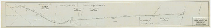
English: A plan for the routing of what would become a section of Texas Park Road 4. Drawn by the Civilian Conservation Corps, 1934. Warmed by uploader in Lightroom (+30) |
| তারিখ | |
| উৎস | File:Texas Park Road 4 CCC Map 1.png |
| লেখক | Civilian Conservation Corps |
লাইসেন্স প্রদান
এই কাজটি মার্কিন যুক্তরাষ্ট্রের পাবলিক ডোমেইনের অন্তর্গত কারণ মার্কিন যুক্তরাষ্ট্রের কোডের শিরোনাম ১৭, পরিচ্ছদ ১, অনুচ্ছেদ ১০৫ শর্তাবলীর অধীনে এটি একটি কাজ যা অফিসিয়াল দায়িত্বের অংশ হিসেবে মার্কিন যুক্তরাষ্ট্র সরকারের কর্মকর্তা বা কর্মচারী দ্বারা প্রস্তুতকৃত । বিস্তারিত জানতে দেখুন কপিরাইট।
টীকা: This only applies to original works of the Federal Government and not to the work of any individual U.S. state, territory, commonwealth, county, municipality, or any other subdivision. This template also does not apply to postage stamp designs published by the United States Postal Service since 1978. (মার্কিন যুক্তরাষ্ট্রে কপিরাইট অফিস চর্চার সারমর্মের § ৩১৩.৬(সি)(১) দেখুন)। এছাড়াও এটি নির্দিষ্ট কয়েকটি মার্কিন ধাতব মুদ্রার জন্য প্রযোজ্য নয়; মার্কিন টাকশালের ব্যবহারের শর্তাবলী দেখুন।
|
 | |
| এই ফাইলটি কপিরাইট আইনের আওতায় জানা সকল বাধানিষেধ মুক্ত বলে চিহ্নিত হয়েছে, যার মধ্যে সম্পর্কিত সকল স্বত্ব ও নেইবারিং সত্ত্ব সংযুক্ত। | ||
This file is in the public domain because The Texas State Library states that: "The Civilian Conservation Corps drawings posted on the Commons are the results of the work of the architects, engineers and draftsmen employed by the Corps, a federally funded New Deal program. There are no known copyright restrictions associated with these drawings." (From here)
|
ফাইলের ইতিহাস
যেকোনো তারিখ/সময়ে ক্লিক করে দেখুন ফাইলটি তখন কী অবস্থায় ছিল।
| তারিখ/সময় | সংক্ষেপচিত্র | মাত্রা | ব্যবহারকারী | মন্তব্য | |
|---|---|---|---|---|---|
| বর্তমান | ০৩:০৬, ২৬ মার্চ ২০১৪ | ৮,১৯১ × ১,১০৪ (৩.৫৫ মেগাবাইট) | A Texas Historian | Minor restoration work: remove the two major creases (stitching errors?) from the scan, work with orange spots, remove some dirt from one area. | |
| ০২:২৫, ১৬ মার্চ ২০১৪ | ৮,১৯১ × ১,১০৪ (২.৭ মেগাবাইট) | Crisco 1492 | Color edit again | ||
| ২৩:২৭, ১৪ মার্চ ২০১৪ | ৮,১৯১ × ১,১০৪ (২.৫৩ মেগাবাইট) | Crisco 1492 | =={{int:filedesc}}== {{Information |description={{en|1=A plan for the routing of what would become a section of Texas Park Road 4. Drawn by the Civilian Conservation Corps, 1934. Warmed by uploader in Lightroom (+30)}} |date=1934-10-25 |source=[[:File:... |
সংযোগসমূহ
নিচের পৃষ্ঠা(গুলো) থেকে এই ছবিতে সংযোগ আছে:
ফাইলের বৈশ্বিক ব্যবহার
নিচের অন্যান্য উইকিগুলো এই ফাইলটি ব্যবহার করে:
- ca.wikipedia.org-এ ব্যবহার
- en.wikipedia.org-এ ব্যবহার
- Civilian Conservation Corps
- Transportation planning
- Wikipedia:Featured picture candidates/March-2014
- Wikipedia:Featured picture candidates/Texas Highway Planning Map
- Wikipedia:Featured picture candidates/Texas Road Planning Map renom
- Wikipedia:Featured picture candidates/April-2014
- Texas Park Road 4
- fa.wikipedia.org-এ ব্যবহার