চিত্র:Tabula hungariae.jpg

এই প্রাকদর্শনের আকার: ৪২১ × ৬০০ পিক্সেল। অন্যান্য আকারসমূহ: ১৬৮ × ২৪০ পিক্সেল | ৩৩৭ × ৪৮০ পিক্সেল | ৫৩৯ × ৭৬৮ পিক্সেল | ৭১৯ × ১,০২৪ পিক্সেল | ১,৪৩৮ × ২,০৪৮ পিক্সেল | ৩,২৩৬ × ৪,৬০৯ পিক্সেল।
পূর্ণ রেজোলিউশন (৩,২৩৬ × ৪,৬০৯ পিক্সেল, ফাইলের আকার: ৩.২৭ মেগাবাইট, এমআইএমই ধরন: image/jpeg)
| এই ফাইলটি উইকিমিডিয়া কমন্স থেকে নেওয়া। সেখানের বর্ণনা পাতার বিস্তারিত নিম্নে দেখানো হলো। (সম্পাদনা)
|
সারাংশ
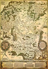
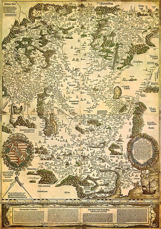
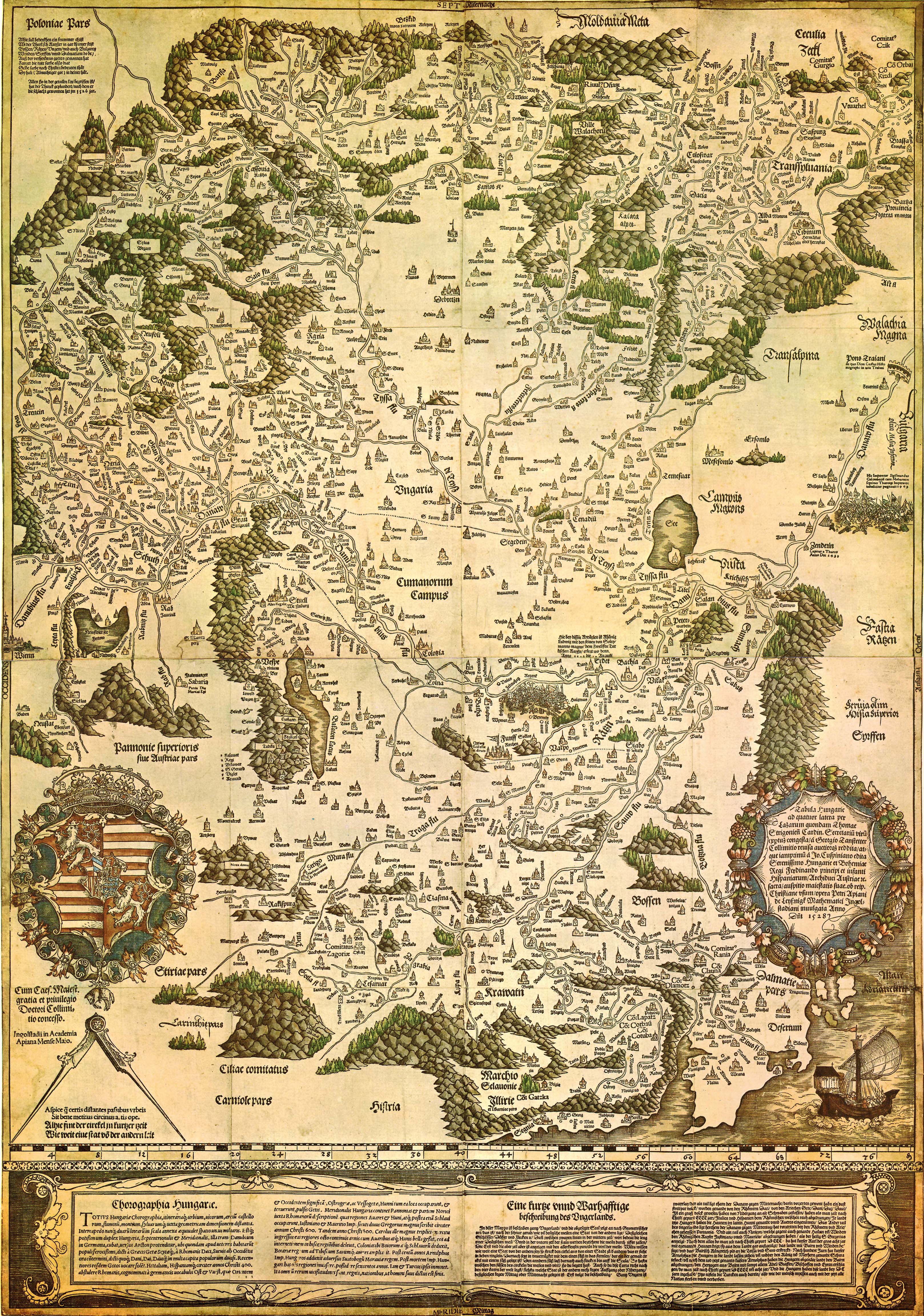
| Tabula Hungariae
|
||
|---|---|---|
| লেখক |
Lázár deák (Lazarus secretarius) |
 |
| শিরোনাম |
লাতিন: Tabula Hungarie ad quatuor latera Tabula Hungariae |
|
| প্রিন্টার | ||
| বস্তুর ধরন |
antique map |
|
| বিবরণ |
Magyar: A Tabula Hungariae vagy Lázár térképe Magyarország első nyomtatott térképe, amelyet a feltehetően a magyar Lázár deák készített Српски / srpski: Lazarusova karta Ugarske iz 1528. godine na kojoj je na mestu današnjeg Novog Sada ubeleženo naselje Bistritz (Bistrica) |
|
| তারিখ | ১৫২৬ এবং ১৫২৮-এর মাঝামাঝি | |
| প্রকাশনার তারিখ |
১৫২৮ |
|
| সংগ্রহ | ||
| তথ্যসূত্র | ||
| কর্তৃপক্ষ নিয়ন্ত্রণ | ||
| উৎস/আলোকচিত্রগ্রাহক | http://lazarus.elte.hu/hun/maps/lazar150.jpg | |
| অন্যান্য সংস্করণ |
|
|


লাইসেন্স প্রদান
|
এই কর্মটি এর উৎস দেশে পাবলিক ডোমেইনে রয়েছে এবং অন্যান্য দেশ ও অঞ্চলে যেখানে কপিরাটের সময়সীমা হচ্ছে লেখকের জীবন যোগ ১০০ বছর বা তাঁর কম। এই কাজটি মার্কিন যুক্তরাষ্ট্রে পাবলিক ডোমেইনে রয়েছে কারণ এটি ১ জানুয়ারি, ১৯২৯ সালের আগে প্রকাশিত (অথবা মার্কিন কপিরাইট অফিসে নিবন্ধিত) হয়েছিল। | |
| এই ফাইলটি কপিরাইট আইনের আওতায় জানা সকল বাধানিষেধ মুক্ত বলে চিহ্নিত হয়েছে, যার মধ্যে সম্পর্কিত সকল স্বত্ব ও নেইবারিং সত্ত্ব সংযুক্ত। | |
ফাইলের ইতিহাস
যেকোনো তারিখ/সময়ে ক্লিক করে দেখুন ফাইলটি তখন কী অবস্থায় ছিল।
| তারিখ/সময় | সংক্ষেপচিত্র | মাত্রা | ব্যবহারকারী | মন্তব্য | |
|---|---|---|---|---|---|
| বর্তমান | ২৩:০২, ২৯ আগস্ট ২০০৯ | | ৩,২৩৬ × ৪,৬০৯ (৩.২৭ মেগাবাইট) | Qorilla | {{Information |Description={{en|1=Tabula Hungariae, first printed map of Hungary}} |Source=Hungarian Wikipedia |Author=Lázár deák (Lazarus secretarius) |Date=somewhere between 1526-1528 |Permission= |other_versions= }} Category:Old maps of Hungary |
সংযোগসমূহ
নিচের পৃষ্ঠা(গুলো) থেকে এই ছবিতে সংযোগ আছে:
ফাইলের বৈশ্বিক ব্যবহার
নিচের অন্যান্য উইকিগুলো এই ফাইলটি ব্যবহার করে:
- ar.wikipedia.org-এ ব্যবহার
- bs.wikipedia.org-এ ব্যবহার
- ca.wikipedia.org-এ ব্যবহার
- de.wikipedia.org-এ ব্যবহার
- el.wikipedia.org-এ ব্যবহার
- en.wikipedia.org-এ ব্যবহার
- Pannonia
- Treaty of Trianon
- Hungarian Revolution of 1956
- Austro-Hungarian Compromise of 1867
- Military Frontier
- Hungarian nobility
- History of Hungary before the Hungarian conquest
- Hungarian prehistory
- Kingdom of Hungary (1526–1867)
- History of geography
- Georg Tannstetter
- Upper Hungary
- History of the Jews in Hungary
- Music history of Hungary
- Bistrica, Novi Sad
- Lands of the Crown of Saint Stephen
- History of Transylvania
- Template:History of Hungary
- Hungarian People's Republic
- Principality of Transylvania (1570–1711)
- Military history of Hungary
- First Hungarian Republic
- Ottoman Hungary
- Hungary between the World Wars
- Principality of Hungary
- Hungarian Revolution of 1848
- Rákóczi's War of Independence
- Eastern Hungarian Kingdom
- Kingdom of Hungary (1920–1946)
- Hungary in World War I
- Second Hungarian Republic
- Mugel
- Tabula Hungariae
এই ফাইলের অন্যান্য বৈশ্বিক ব্যবহার দেখুন।