চিত্র:Road network CPEC.jpg
এই প্রাকদর্শনের আকার: ৭৯৯ × ৬০০ পিক্সেল। অন্যান্য আকারসমূহ: ৩২০ × ২৪০ পিক্সেল | ৬৪০ × ৪৮০ পিক্সেল | ৯৬২ × ৭২২ পিক্সেল।
পূর্ণ রেজোলিউশন (৯৬২ × ৭২২ পিক্সেল, ফাইলের আকার: ১৩৭ কিলোবাইট, এমআইএমই ধরন: image/jpeg)
| এই ফাইলটি উইকিমিডিয়া কমন্স থেকে নেওয়া। সেখানের বর্ণনা পাতার বিস্তারিত নিম্নে দেখানো হলো। (সম্পাদনা)
|
সারাংশ
| বিবরণ |
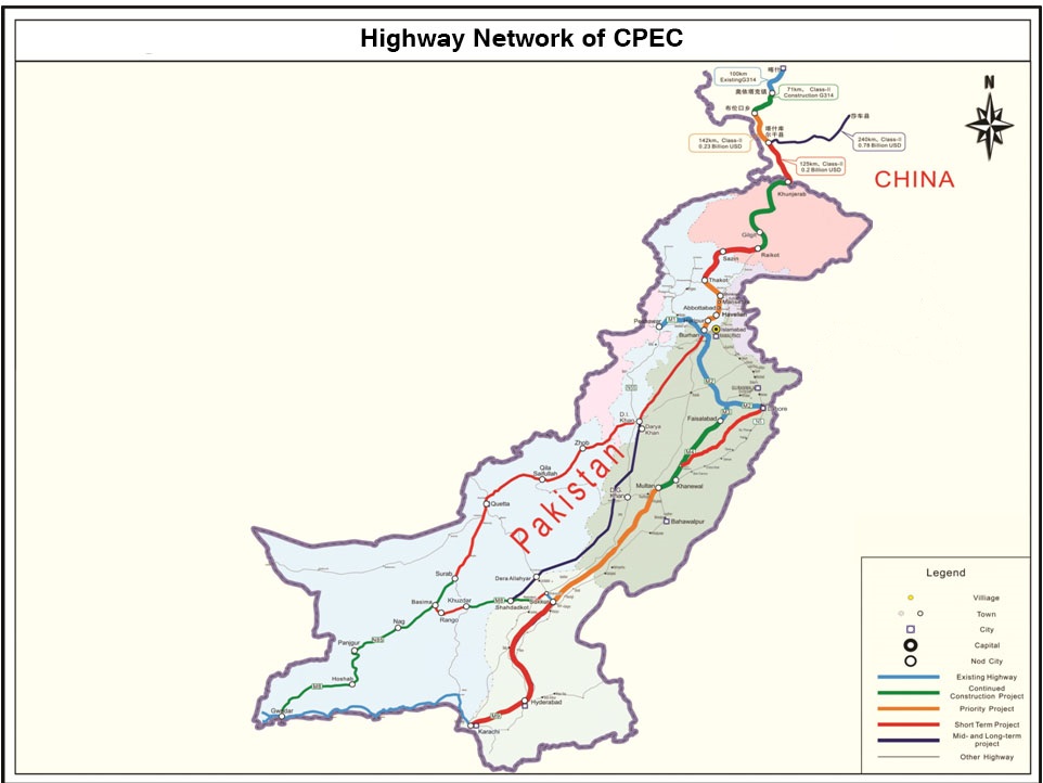
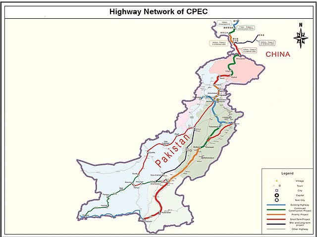
English: It describes Eastern Western and Central alignment of CPEC |
| তারিখ | |
| উৎস | http://www.pc.gov.pk/wp-content/uploads/2016/01/Highway-Network-of-cpac-new.jpg |
| লেখক | Government of Pakistan |
This file is in the public domain because Planning commision of Pakistan
|
ফাইলের ইতিহাস
যেকোনো তারিখ/সময়ে ক্লিক করে দেখুন ফাইলটি তখন কী অবস্থায় ছিল।
| তারিখ/সময় | সংক্ষেপচিত্র | মাত্রা | ব্যবহারকারী | মন্তব্য | |
|---|---|---|---|---|---|
| বর্তমান | ০০:১৯, ২৮ সেপ্টেম্বর ২০২৩ | | ৯৬২ × ৭২২ (১৩৭ কিলোবাইট) | Eggrollll | Reverted to version as of 17:10, 4 December 2020 (UTC) |
| ১৭:১১, ৪ ডিসেম্বর ২০২০ |  | ৯৬২ × ৭২২ (১২৫ কিলোবাইট) | Pathfinder454 | Map published by user Badri2017 is forged / edited without copyrights obtained from Government of Pakistan. Original file published by user Baltistani478 is the actual map depicting road networks of CPEC as published at official website http://cpec.gov.pk/map-single/1 Therefore File Reverted to version as of 16:49, 23 May 2016 (UTC) | |
| ১৭:১০, ৪ ডিসেম্বর ২০২০ |  | ৯৬২ × ৭২২ (১৩৭ কিলোবাইট) | Pathfinder454 | Reverted to version as of 10:15, 19 July 2017 (UTC) Map published by user Badri2017 is forged / edited without copyrights obtained from Government of Pakistan. Original file published by user Baltistani478 is the actual map depicting road networks of CPEC as published at official website http://cpec.gov.pk/map-single/1 Therefore File Reverted to version as of 16:49, 23 May 2016 (UTC | |
| ১৭:০১, ৪ ডিসেম্বর ২০২০ |  | ৯৬২ × ৭২২ (১২৫ কিলোবাইট) | Pathfinder454 | Map published by user Badri2017 is forged / edited without copyrights obtained from Government of Pakistan. Original file published by user Baltistani478 is the actual map depicting road networks of CPEC as published at official website http://cpec.gov.pk/map-single/1 Therefore File Reverted to version as of 16:49, 23 May 2016 (UTC) | |
| ১০:১৫, ১৯ জুলাই ২০১৭ |  | ৯৬২ × ৭২২ (১৩৭ কিলোবাইট) | Badri2017 | Neutral Map, Indian administered Kashmir is neither part of CPEC nor Pak territory | |
| ১৬:৪৯, ২৩ মে ২০১৬ |  | ৯৬২ × ৭২২ (১২৫ কিলোবাইট) | Baltistani478 | {{subst:Upload marker added by en.wp UW}} {{Information |Description = {{en|It describes Eastern Western and Central alignment of CPEC}} |Source = http://www.pc.gov.pk/wp-content/uploads/2016/01/Highway-Network-of-cpac-new.jpg |Date = January 2016 |Aut... |
সংযোগসমূহ
নিচের পৃষ্ঠা(গুলো) থেকে এই ছবিতে সংযোগ আছে:
ফাইলের বৈশ্বিক ব্যবহার
নিচের অন্যান্য উইকিগুলো এই ফাইলটি ব্যবহার করে:
- ar.wikipedia.org-এ ব্যবহার
- ca.wikipedia.org-এ ব্যবহার
- en.wikipedia.org-এ ব্যবহার
- eo.wikinews.org-এ ব্যবহার
- hi.wikipedia.org-এ ব্যবহার
- mr.wikipedia.org-এ ব্যবহার
- pa.wikipedia.org-এ ব্যবহার
- pnb.wikipedia.org-এ ব্যবহার
- sat.wikipedia.org-এ ব্যবহার
- sd.wikipedia.org-এ ব্যবহার
- ta.wikipedia.org-এ ব্যবহার
- zh.wikipedia.org-এ ব্যবহার