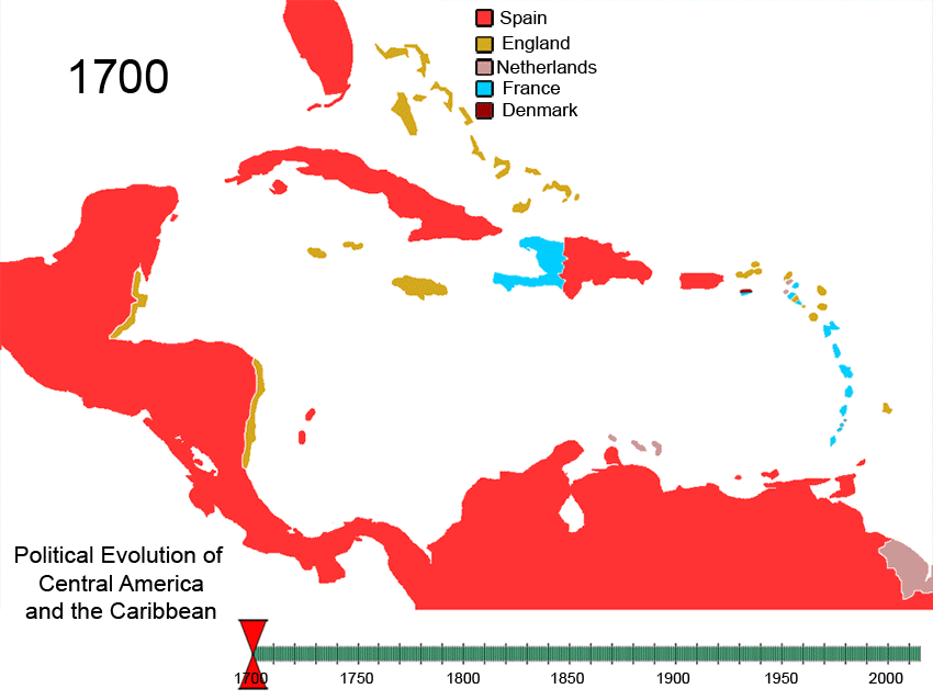
চিত্র:Political Evolution of Central America and the Caribbean 1700 and on.gif
এই প্রাকদর্শনের আকার: ৭৯৯ × ৬০০ পিক্সেল। অন্যান্য আকারসমূহ: ৩২০ × ২৪০ পিক্সেল | ৬৪০ × ৪৮০ পিক্সেল | ৮৫০ × ৬৩৮ পিক্সেল।
পূর্ণ রেজোলিউশন (৮৫০ × ৬৩৮ পিক্সেল, ফাইলের আকার: ৩৪৮ কিলোবাইট, এমআইএমই ধরন: image/gif, লুপকৃত, ৭৫ ফ্রেম, ৩ মি ৩ সে)
| এই ফাইলটি উইকিমিডিয়া কমন্স থেকে নেওয়া। সেখানের বর্ণনা পাতার বিস্তারিত নিম্নে দেখানো হলো। (সম্পাদনা)
|

|
This historical map image could be re-created using vector graphics as an SVG file. This has several advantages; see Commons:Media for cleanup for more information. If an SVG form of this image is available, please upload it and afterwards replace this template with
{{vector version available|new image name}}.
It is recommended to name the SVG file “Political Evolution of Central America and the Caribbean 1700 and on.svg”—then the template Vector version available (or Vva) does not need the new image name parameter. |
| Caribbean | |||
|---|---|---|---|
| Antigua and Barbuda | |||
| Bahamas | |||
| Barbados | |||
| Belize | |||
| Cuba | |||
| Denmark | |||
| Dominica | |||
| Dominican Republic | |||
| Grenada | |||
| Haiti | |||
| Netherlands | |||
| Jamaica | |||
| Saint Kitts and Nevis | |||
| Saint Lucia | |||
| Saint Vincent and the Grenadines | |||
| Sweden | |||
| Trinidad and Tobago | |||
| United Kingdom | |||
| Spain | |||
| France | |||
| West Indies Federation | |||
| Central America | |||
| Costa Rica | |||
| El Salvador | |||
| Guatemala | |||
| Honduras | |||
| Nicaragua | |||
| Panama | |||
| Spain | |||
| Federal Republic of Central America | |||
| North America | |||
| Viceroyalty of New Spain | |||
| Yucatán (Republic of Yucatan) | |||
| Mexico | |||
| United States of America | |||
| South America | |||
| Viceroyalty of New Granada | |||
| Gran Colombia | |||
| Colombia | |||
| Venezuela | |||
| Guyana | |||
| *Flags used are flags of present day countries or the last flag used by a now-defunct nation. | |||
To recreate this animated gif you can use the following slides:


See Also
-
 North America
 -
 Central America
 -
 Balkans
 -
 South America


Italic text
References
| বিবরণ | Political_Evolution_of_Central_America_and_the_Caribbean_1700_and_on | ||
| তারিখ | |||
| উৎস | নিজের কাজ | ||
| লেখক | Esemono | ||
| অনুমতি (এ ফাইলের পুনঃব্যবহার) |
|
ফাইলের ইতিহাস
যেকোনো তারিখ/সময়ে ক্লিক করে দেখুন ফাইলটি তখন কী অবস্থায় ছিল।
| তারিখ/সময় | সংক্ষেপচিত্র | মাত্রা | ব্যবহারকারী | মন্তব্য | |
|---|---|---|---|---|---|
| বর্তমান | ১০:৩০, ২৭ ফেব্রুয়ারি ২০১০ | | ৮৫০ × ৬৩৮ (৩৪৮ কিলোবাইট) | Esemono | Fix dominica occuaption |
| ০১:৫৫, ৫ মে ২০০৯ |  | ১,০০০ × ৭৫০ (৪১৪ কিলোবাইট) | Esemono | Small date error | |
| ০০:০২, ৫ মে ২০০৯ |  | ১,০০০ × ৭৫০ (৪২২ কিলোবাইট) | Esemono | CSA Belize Panama Zone correction USA Netherlands | |
| ০৩:২৩, ২৯ এপ্রিল ২০০৯ |  | ১,০০০ × ৭৫০ (৩৯৬ কিলোবাইট) | Esemono | eng to uk | |
| ০৬:০৮, ২ এপ্রিল ২০০৯ |  | ১,০০০ × ৭৫০ (৩৯৭ কিলোবাইট) | Esemono | Update add panama zone | |
| ১১:২২, ২ এপ্রিল ২০০৮ |  | ১,০০০ × ৭৫০ (৩৯২ কিলোবাইট) | Esemono | {| align="right" border="0" style="border:1px solid #000000;" |+'''Nations past and present of the Caribbean''' |- ! colspan="4" | '''Caribbean''' |- | bgcolor="cc9933" width="30"| | width="10"| |Antigua and Barbuda |{{flagico |
সংযোগসমূহ
নিচের পৃষ্ঠা(গুলো) থেকে এই ছবিতে সংযোগ আছে:
ফাইলের বৈশ্বিক ব্যবহার
নিচের অন্যান্য উইকিগুলো এই ফাইলটি ব্যবহার করে:
- af.wikipedia.org-এ ব্যবহার
- ar.wikipedia.org-এ ব্যবহার
- ast.wikipedia.org-এ ব্যবহার
- ba.wikipedia.org-এ ব্যবহার
- bg.wikipedia.org-এ ব্যবহার
- ca.wikipedia.org-এ ব্যবহার
- cs.wikipedia.org-এ ব্যবহার
- cv.wikipedia.org-এ ব্যবহার
- de.wikipedia.org-এ ব্যবহার
- el.wikipedia.org-এ ব্যবহার
- en.wikipedia.org-এ ব্যবহার
- History of the Americas
- History of Jamaica
- History of the Caribbean
- History of Central America
- Portal:Caribbean
- List of conflicts in North America
- Portal:Jamaica
- List of land borders with dates of establishment
- Caribbean
- Territorial evolution of the Caribbean
- Talk:Latin America/Archive 3
- Invasion of Jamaica
- Colony of Jamaica
- es.wikipedia.org-এ ব্যবহার
- eu.wikipedia.org-এ ব্যবহার
- fa.wikipedia.org-এ ব্যবহার
- fiu-vro.wikipedia.org-এ ব্যবহার
- fi.wikipedia.org-এ ব্যবহার
- fr.wikipedia.org-এ ব্যবহার
- fy.wikipedia.org-এ ব্যবহার
- hu.wikipedia.org-এ ব্যবহার
এই ফাইলের অন্যান্য বৈশ্বিক ব্যবহার দেখুন।