চিত্র:Percentage population undernourished world map.PNG

এই প্রাকদর্শনের আকার: ৮০০ × ৩৬২ পিক্সেল। অন্যান্য আকারসমূহ: ৩২০ × ১৪৫ পিক্সেল | ৬৪০ × ২৮৯ পিক্সেল | ১,২৩৭ × ৫৫৯ পিক্সেল।
পূর্ণ রেজোলিউশন (১,২৩৭ × ৫৫৯ পিক্সেল, ফাইলের আকার: ১৬১ কিলোবাইট, এমআইএমই ধরন: image/png)
| এই ফাইলটি উইকিমিডিয়া কমন্স থেকে নেওয়া। সেখানের বর্ণনা পাতার বিস্তারিত নিম্নে দেখানো হলো। (সম্পাদনা)
|
সারাংশ
| বিবরণ |
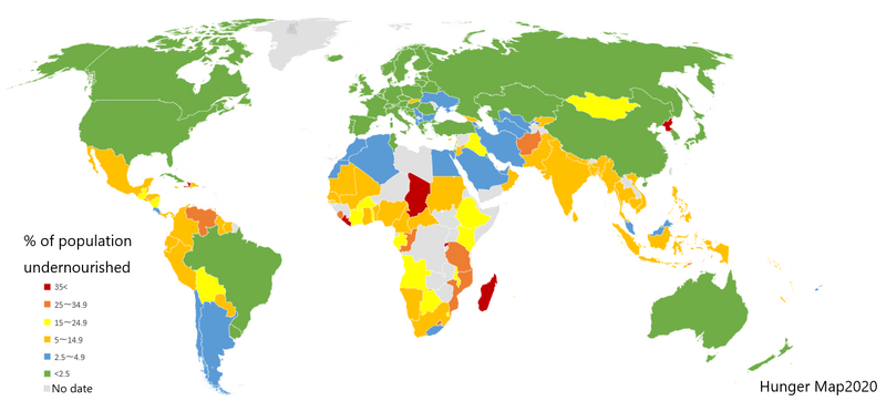
English: List of countries by percentage of population suffering from undernourishment. Made by jp:User:Fnweirkmnwperojvnu, using Map of Excel. The map has been updated (on 2021-01-11) according to the "Hunger Map 2020" from the United Nations World Food Programme.
Sources: Sustainable Development Goal indicators website "Global SDG Indicators Database>GOLE2 End hunger, achieve food security and improved nutrition and promote sustainable agriculture": https://unstats.un.org/sdgs/indicators/database/?indicator=2.1.1 United Nations World Food Programme's interactive "hunger map": http://cdn.wfp.org/hungermap/ Hunger Map 2020: https://www.wfp.org/publications/hunger-map-2020 |
| তারিখ | ১১ জানুয়ারি ২০২১ (মূল আপলোডের তারিখ) |
| উৎস | en.wikipedia থেকে কমন্সে স্থানান্তরিত করা হয়েছে। |
| লেখক | মূল আপলোডকারী ছিলেন jp উইকিপিডিয়া-এর Fnweirkmnwperojvnu |
| অন্যান্য সংস্করণ |
এই ফাইলের উপজাত কর্মসমূহ: Percentage population undernourished world map-ar.PNG  |


|
This map image could be re-created using vector graphics as an SVG file. This has several advantages; see Commons:Media for cleanup for more information. If an SVG form of this image is available, please upload it and afterwards replace this template with
{{vector version available|new image name}}.
It is recommended to name the SVG file “Percentage population undernourished world map.svg”—then the template Vector version available (or Vva) does not need the new image name parameter. |
লাইসেন্স প্রদান

|
এই নথি অনুলিপি, বিতরণ এবং/বা পরিবর্তন করার অনুমতি ফ্রি সফটওয়্যার ফাউন্ডেশন কর্তৃক প্রকাশিত গনু ফ্রি ডকুমেন্টেশন লাইসেন্স, সংস্করণ ১.২ বা তার পরবর্তী সংস্করণের আওতায় অনুমতিপ্রাপ্ত; যে কোনো রকম অনুচ্ছেদ পরিবর্তন, সম্মুখ-প্রচ্ছদের লেখা, পিছন-প্রচ্ছদের লেখা পরিবর্তন করা ছাড়াই। এই লাইসেন্সের একটি অনুলিপি গনু ফ্রি ডকুমেন্টেশন লাইসেন্স শিরোনামের অনুচ্ছেদে অন্তর্ভুক্ত করা আছে। |
| এই ফাইলটি ক্রিয়েটিভ কমন্স অ্যাট্রিবিউশন-শেয়ার অ্যালাইক ৩.০ আনপোর্টেড লাইসেন্সের আওতায় লাইসেন্সকৃত। | ||
| ||
| এই লাইসেন্স ট্যাগটি জিএফডিএল লাইসেন্স হালনাগাদের অংশ হিসেবে এই ফাইলে সংযুক্ত হয়েছে। |
মূল আপলোড লগ
মূল বিবরণ পাতাটি এখানে ছিল। নিম্নলিখিত সকল ব্যবহারকারীর নাম en.wikipedia-এ উল্লেখ করা ছিল।
- 2007-03-23 02:31 Lobizón 1355×768×8 (58226 bytes) List of countries by percentage of population suffering from undernourishment. Made from Wikipedia's "map of the world" template, using information from the United Nations World Food Programme and the FAO "The State of Food Insecurity in the World 2006" r
ফাইলের ইতিহাস
যেকোনো তারিখ/সময়ে ক্লিক করে দেখুন ফাইলটি তখন কী অবস্থায় ছিল।
| তারিখ/সময় | সংক্ষেপচিত্র | মাত্রা | ব্যবহারকারী | মন্তব্য | |
|---|---|---|---|---|---|
| বর্তমান | ১৬:৩১, ১০ জানুয়ারি ২০২১ | | ১,২৩৭ × ৫৫৯ (১৬১ কিলোবাইট) | Fnweirkmnwperojvnu | data updates |
| ২১:০৭, ১৮ জুলাই ২০২০ |  | ১,৩৫৭ × ৬২৮ (৪৭ কিলোবাইট) | Maphobbyist | South Sudan border | |
| ১৮:৩০, ১৬ এপ্রিল ২০১৬ |  | ১,৩৫৭ × ৬২৮ (৪৬ কিলোবাইট) | Kontrollstellekundl | updated according to the "Hunger Map 2013" http://documents.wfp.org/stellent/groups/public/documents/communications/wfp229327.pdf | |
| ১২:২০, ২৮ ফেব্রুয়ারি ২০১৬ |  | ১,৩৫৭ × ৬২৮ (৪৫ কিলোবাইট) | Kontrollstellekundl | cropped | |
| ১৪:০৮, ১৫ আগস্ট ২০১৫ |  | ১,৩৫৫ × ৭৬৮ (৪৬ কিলোবাইট) | Jamie Tubers | update | |
| ০৪:৩৮, ৩১ ডিসেম্বর ২০১৩ |  | ১,৩৫৫ × ৭৬৮ (৫৬ কিলোবাইট) | Varitia | Small correction on Indonesia | |
| ০৪:১৯, ৩১ ডিসেম্বর ২০১৩ |  | ১,৩৫৫ × ৭৬৮ (৫৬ কিলোবাইট) | Varitia | Update to 2012 figures and parameters according to the United Nations World Food Programme | |
| ২৩:০৪, ৪ মে ২০০৮ |  | ১,৩৫৫ × ৭৬৮ (৫৬ কিলোবাইট) | Dwrcan | Updates. (Note: click on the actual countries of the source map, the actual data sometimes doesn't match the color of the country.) | |
| ২১:০০, ১০ নভেম্বর ২০০৭ |  | ১,৩৫৫ × ৭৬৮ (৫৭ কিলোবাইট) | Béka~commonswiki | {{Information |Description={{en|List of countries by percentile of population suffering from undernourishment. Made by en:User:Lobizón, using Wikipedia's "map of the world" template, and information from the United Nations World Food Programme and t |
সংযোগসমূহ
নিচের পৃষ্ঠা(গুলো) থেকে এই ছবিতে সংযোগ আছে:
ফাইলের বৈশ্বিক ব্যবহার
নিচের অন্যান্য উইকিগুলো এই ফাইলটি ব্যবহার করে:
- af.wikipedia.org-এ ব্যবহার
- ast.wikipedia.org-এ ব্যবহার
- ba.wikipedia.org-এ ব্যবহার
- bg.wikipedia.org-এ ব্যবহার
- cs.wikipedia.org-এ ব্যবহার
- cv.wikipedia.org-এ ব্যবহার
- de.wikipedia.org-এ ব্যবহার
- en.wikipedia.org-এ ব্যবহার
- en.wikinews.org-এ ব্যবহার
- eo.wikipedia.org-এ ব্যবহার
- es.wikipedia.org-এ ব্যবহার
- es.wikinews.org-এ ব্যবহার
- eu.wikipedia.org-এ ব্যবহার
- fa.wikipedia.org-এ ব্যবহার
- fi.wikipedia.org-এ ব্যবহার
- fy.wikipedia.org-এ ব্যবহার
- gu.wikipedia.org-এ ব্যবহার
- he.wikipedia.org-এ ব্যবহার
- hr.wikipedia.org-এ ব্যবহার
- hu.wikipedia.org-এ ব্যবহার
- hy.wikipedia.org-এ ব্যবহার
- id.wikipedia.org-এ ব্যবহার
- is.wikipedia.org-এ ব্যবহার
- it.wikipedia.org-এ ব্যবহার
- ja.wikipedia.org-এ ব্যবহার
- kn.wikipedia.org-এ ব্যবহার
- la.wikipedia.org-এ ব্যবহার
- lmo.wikipedia.org-এ ব্যবহার
- lt.wikipedia.org-এ ব্যবহার
- lv.wikipedia.org-এ ব্যবহার
- mk.wikipedia.org-এ ব্যবহার
এই ফাইলের অন্যান্য বৈশ্বিক ব্যবহার দেখুন।