চিত্র:Ossetia01.png
এই প্রাকদর্শনের আকার: ৩৯১ × ৫৯৯ পিক্সেল। অন্যান্য আকারসমূহ: ১৫৬ × ২৪০ পিক্সেল | ৩১৩ × ৪৮০ পিক্সেল | ৬৯৬ × ১,০৬৭ পিক্সেল।
পূর্ণ রেজোলিউশন (৬৯৬ × ১,০৬৭ পিক্সেল, ফাইলের আকার: ৪৯ কিলোবাইট, এমআইএমই ধরন: image/png)
| এই ফাইলটি উইকিমিডিয়া কমন্স থেকে নেওয়া। সেখানের বর্ণনা পাতার বিস্তারিত নিম্নে দেখানো হলো। (সম্পাদনা)
|

|
This map image could be re-created using vector graphics as an SVG file. This has several advantages; see Commons:Media for cleanup for more information. If an SVG form of this image is available, please upload it and afterwards replace this template with
{{vector version available|new image name}}.
It is recommended to name the SVG file “Ossetia01.svg”—then the template Vector version available (or Vva) does not need the new image name parameter. |
সারাংশ
| বিবরণ |
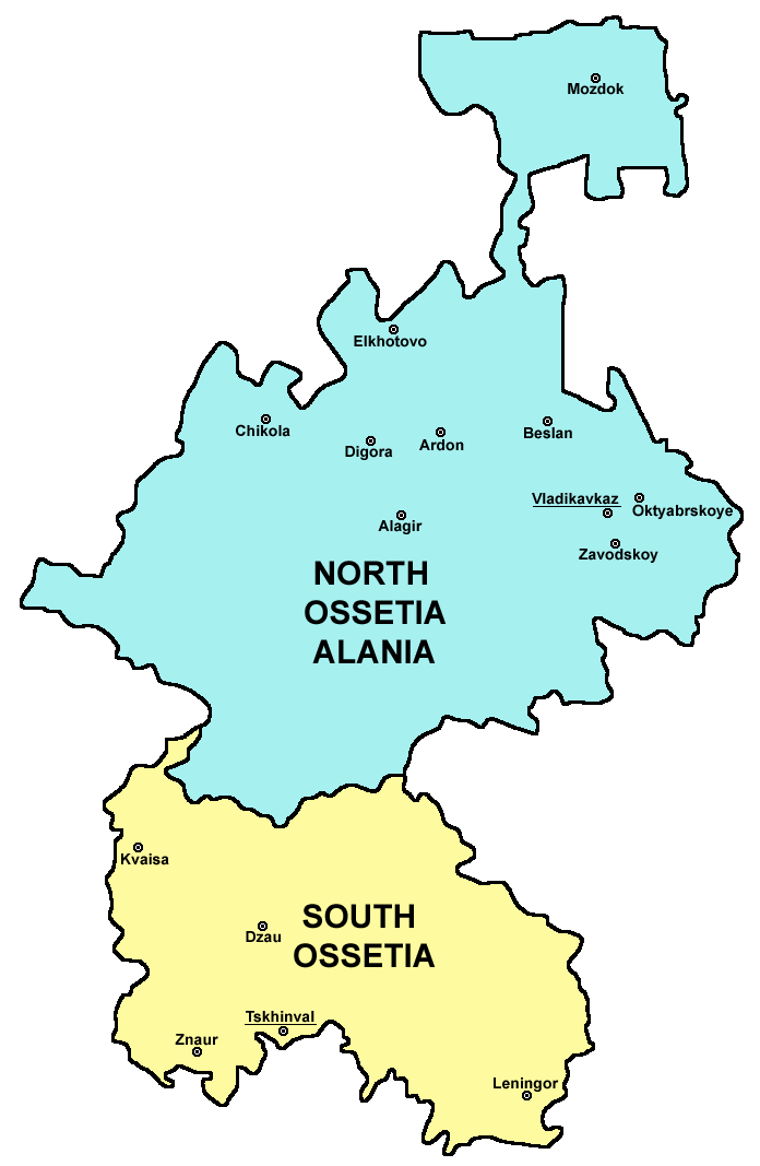
English: Map of Ossetia (North Ossetia and South Ossetia). |
| তারিখ | ১৯ ডিসেম্বর ২০০৬ (মূল আপলোডের তারিখ) |
| উৎস | নিজের কাজ |
| লেখক | PANONIAN |
লাইসেন্স প্রদান
self made map by user:PANONIAN
| আমি, এই কাজের স্বত্বাধিকারী, এতদ্দ্বারা আমি এই কাজকে পাবলিক ডোমেইন লাইসেন্সের আওতায় প্রকাশ করলাম। এটি বিশ্বব্যাপী প্রযোজ্য হবে। কিছু দেশে এটি আইনত সিদ্ধ নাও হতে পারে, যদি তাই হয়: আমি যে-কাউকে এই কাজটি যেকোনো উদ্দেশ্যে, বিনাশর্তে ব্যবহারের অনুমতি প্রদান করছি, যদি না সেই শর্তগুলো আইনত প্রয়োজনীয় হয়। |

|
This map has been uploaded by Electionworld from en.wikipedia.org to enable the |
References
Borders and locations of major settlements:
- http://iratta.com/uploads/posts/atlas/21/karta.jpg
- http://foto.mail.ru/bk/lyks2003/150/163.html
- http://4.bp.blogspot.com/_PB5-El7se4s/SJzcr3lGyAI/AAAAAAAAISU/kagljy4-1b0/s400/ossetia+map.jpg
- http://static.guim.co.uk/sys-images/Guardian/Pix/pictures/2008/8/8/1218195196317/ossetia220.jpg
- http://www.pri.org/theworld/files/images/ossetia_map.jpg
List of larger settlements:
derivative works
এই ফাইলের উপজাত কর্মসমূহ:
- Ossetia01-he.png
- Osetia del norte y del sur.png
- Ossetia Nord i Sud.png
- Ossetia kaart.png
- Ossetia rus.png
- Ossetia01 (tr).png
- Ossetia-sr.png
- http://en.wikipedia.org/wiki/File:UnitedOssetia.png
.png)
ফাইলের ইতিহাস
যেকোনো তারিখ/সময়ে ক্লিক করে দেখুন ফাইলটি তখন কী অবস্থায় ছিল।
| তারিখ/সময় | সংক্ষেপচিত্র | মাত্রা | ব্যবহারকারী | মন্তব্য | |
|---|---|---|---|---|---|
| বর্তমান | ২৩:১৬, ৫ মার্চ ২০১১ | | ৬৯৬ × ১,০৬৭ (৪৯ কিলোবাইট) | PANONIAN | improved version |
| ২২:৫৩, ১৯ ডিসেম্বর ২০০৬ |  | ৪৫৩ × ৬৭৪ (২২ কিলোবাইট) | Electionworld | {{ew|en|PANONIAN}} map of Ossetia (self made) {{PD-self}} Category:Caucasus maps Category:Maps of the Russian republics Category:Maps of Georgia |
সংযোগসমূহ
নিচের পৃষ্ঠা(গুলো) থেকে এই ছবিতে সংযোগ আছে:
ফাইলের বৈশ্বিক ব্যবহার
নিচের অন্যান্য উইকিগুলো এই ফাইলটি ব্যবহার করে:
- ar.wikipedia.org-এ ব্যবহার
- cs.wikipedia.org-এ ব্যবহার
- cs.wikinews.org-এ ব্যবহার
- de.wikipedia.org-এ ব্যবহার
- diq.wikipedia.org-এ ব্যবহার
- el.wikipedia.org-এ ব্যবহার
- en.wikipedia.org-এ ব্যবহার
- es.wikipedia.org-এ ব্যবহার
- eu.wikipedia.org-এ ব্যবহার
- fa.wikipedia.org-এ ব্যবহার
- fi.wikipedia.org-এ ব্যবহার
- ga.wikipedia.org-এ ব্যবহার
- hr.wikipedia.org-এ ব্যবহার
- hy.wikipedia.org-এ ব্যবহার
- it.wikipedia.org-এ ব্যবহার
- ko.wikipedia.org-এ ব্যবহার
- ku.wikipedia.org-এ ব্যবহার
- la.wikipedia.org-এ ব্যবহার
- lt.wikipedia.org-এ ব্যবহার
- ms.wikipedia.org-এ ব্যবহার
- nds.wikipedia.org-এ ব্যবহার
- nl.wikipedia.org-এ ব্যবহার
- nn.wikipedia.org-এ ব্যবহার
- no.wikipedia.org-এ ব্যবহার
- pl.wikipedia.org-এ ব্যবহার
- pl.wiktionary.org-এ ব্যবহার
- pt.wikipedia.org-এ ব্যবহার
- ru.wiktionary.org-এ ব্যবহার
- rw.wikipedia.org-এ ব্যবহার
- sco.wikipedia.org-এ ব্যবহার
- simple.wikipedia.org-এ ব্যবহার
- sk.wikipedia.org-এ ব্যবহার
- sq.wikipedia.org-এ ব্যবহার
- sv.wikipedia.org-এ ব্যবহার
- tt.wikipedia.org-এ ব্যবহার
- uk.wikipedia.org-এ ব্যবহার
- vi.wikipedia.org-এ ব্যবহার