চিত্র:Ohio Country en.png
এই প্রাকদর্শনের আকার: ৭৯৩ × ৫৯৯ পিক্সেল। অন্যান্য আকারসমূহ: ৩১৮ × ২৪০ পিক্সেল | ৬৩৫ × ৪৮০ পিক্সেল | ১,০১৬ × ৭৬৮ পিক্সেল | ১,২১৭ × ৯২০ পিক্সেল।
পূর্ণ রেজোলিউশন (১,২১৭ × ৯২০ পিক্সেল, ফাইলের আকার: ১.৪১ মেগাবাইট, এমআইএমই ধরন: image/png)
| এই ফাইলটি উইকিমিডিয়া কমন্স থেকে নেওয়া। সেখানের বর্ণনা পাতার বিস্তারিত নিম্নে দেখানো হলো। (সম্পাদনা)
|
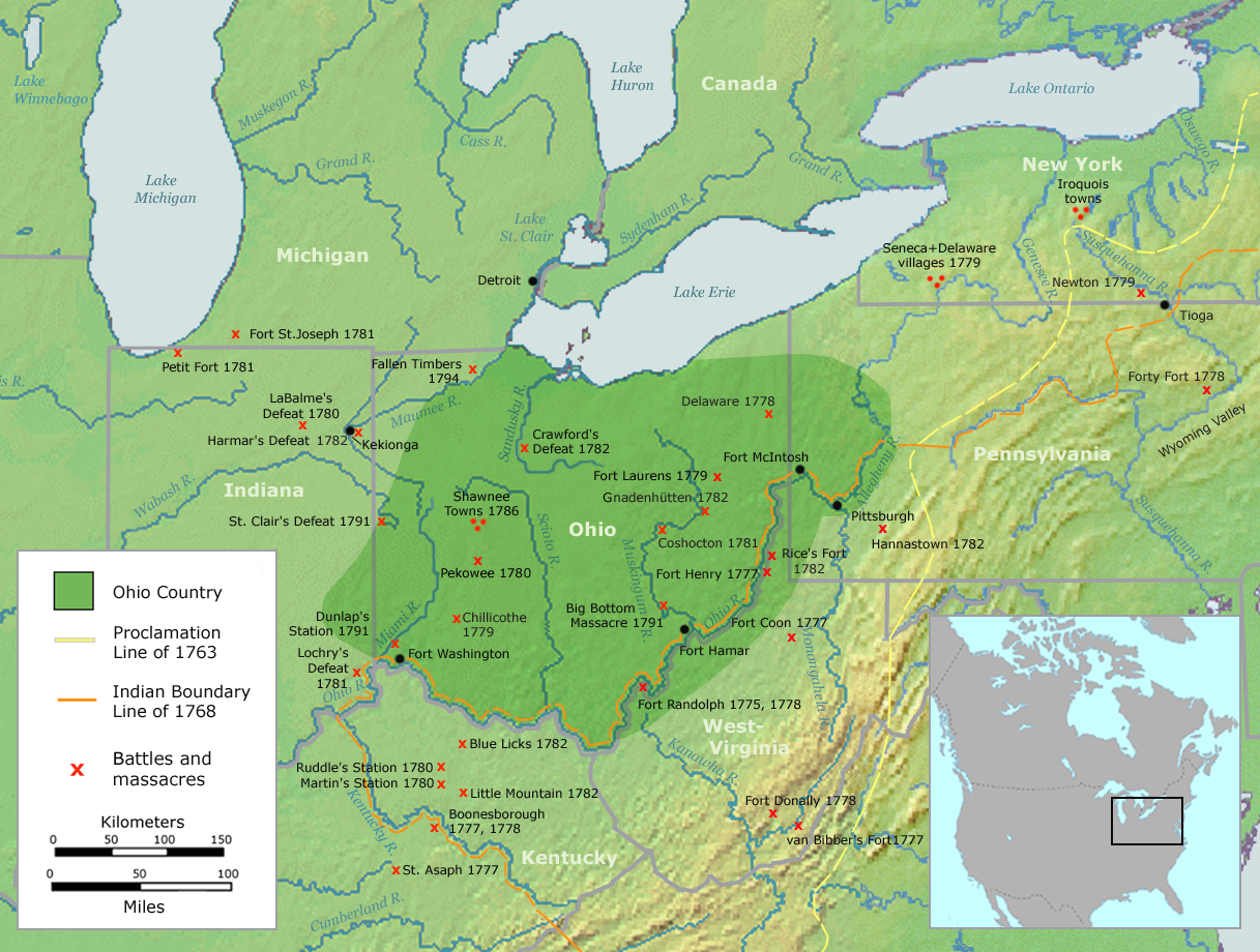
| বিবরণ | Map of the Ohio Country (English version) | ||||
| তারিখ | |||||
| উৎস | Own work by Nikater, submitted to the public domain. Background map courtesy of Demis, www.demis.nl and Wilcomb E. Washburn (Hrsg.) Handbook of North American Indians. Vol. 4: History of Indian-White Relations. Smithsonian Institution Press, Washington D.C. 1988. ISBN 0-16004-583-5 | ||||
| লেখক | User:Nikater | ||||
| অনুমতি (এ ফাইলের পুনঃব্যবহার) |
|
||||
| অন্যান্য সংস্করণ | Deutsch |
ফাইলের ইতিহাস
যেকোনো তারিখ/সময়ে ক্লিক করে দেখুন ফাইলটি তখন কী অবস্থায় ছিল।
| তারিখ/সময় | সংক্ষেপচিত্র | মাত্রা | ব্যবহারকারী | মন্তব্য | |
|---|---|---|---|---|---|
| বর্তমান | ০৬:২০, ২১ সেপ্টেম্বর ২০০৭ | | ১,২১৭ × ৯২০ (১.৪১ মেগাবাইট) | Nikater | {{Information |Description=Map of the Ohio Country (English version) |Source=Own work by Nikater, submitted to the public domain. Background map courtesy of Demis, www.demis.nl and Wilcomb E. Washburn (Hrsg.) ''Handbook of North American Indians.'' Vol. 4 |
| ১১:৫০, ২০ সেপ্টেম্বর ২০০৭ |  | ১,২১৭ × ৯২০ (১.৪১ মেগাবাইট) | Nikater | {{Information |Description=Map of the Ohio Country (English version) |Source=Own work by Nikater, submitted to the public domain. Background map courtesy of Demis, www.demis.nl and Wilcomb E. Washburn (Hrsg.) ''Handbook of North American Indians.'' Vol. 4 | |
| ২০:২১, ১৭ সেপ্টেম্বর ২০০৭ |  | ১,২১৭ × ৯২০ (১.৪১ মেগাবাইট) | Nikater | {{Information |Description=Map of the Ohio Country (English version) |Source=Own work by Nikater, submitted to the public domain. Background map courtesy of Demis, www.demis.nl and Wilcomb E. Washburn (Hrsg.) ''Handbook of North American Indians.'' Vol. 4 | |
| ২০:০৫, ১৭ সেপ্টেম্বর ২০০৭ |  | ১,২১৭ × ৯২০ (১.৪১ মেগাবাইট) | Nikater | {{Information |Description=Map of the Ohio Country (English version) |Source=Own work by Nikater, submitted to the public domain. Background map courtesy of Demis, www.demis.nl and Wilcomb E. Washburn (Hrsg.) ''Handbook of North American Indians.'' Vol. 4 |
সংযোগসমূহ
নিচের পৃষ্ঠা(গুলো) থেকে এই ছবিতে সংযোগ আছে:
ফাইলের বৈশ্বিক ব্যবহার
নিচের অন্যান্য উইকিগুলো এই ফাইলটি ব্যবহার করে:
- ar.wikipedia.org-এ ব্যবহার
- arz.wikipedia.org-এ ব্যবহার
- ast.wikipedia.org-এ ব্যবহার
- ca.wikipedia.org-এ ব্যবহার
- cs.wikipedia.org-এ ব্যবহার
- en.wikipedia.org-এ ব্যবহার
- es.wikipedia.org-এ ব্যবহার
- fr.wikipedia.org-এ ব্যবহার
- gl.wikipedia.org-এ ব্যবহার
- id.wikipedia.org-এ ব্যবহার
- ja.wikipedia.org-এ ব্যবহার
- ko.wikipedia.org-এ ব্যবহার
- ms.wikipedia.org-এ ব্যবহার
- no.wikipedia.org-এ ব্যবহার
- pl.wikipedia.org-এ ব্যবহার
- ro.wikipedia.org-এ ব্যবহার
- ru.wikipedia.org-এ ব্যবহার
- so.wikipedia.org-এ ব্যবহার
- sq.wikipedia.org-এ ব্যবহার
- sv.wikipedia.org-এ ব্যবহার
- tr.wikipedia.org-এ ব্যবহার
- www.wikidata.org-এ ব্যবহার