চিত্র:North ossetia map.png
এর চেয়ে বেশি রেজোলিউশন লভ্য নয়।
North_ossetia_map.png (৩০৪ × ৩৭৭ পিক্সেল, ফাইলের আকার: ২৩ কিলোবাইট, এমআইএমই ধরন: image/png)
| এই ফাইলটি উইকিমিডিয়া কমন্স থেকে নেওয়া। সেখানের বর্ণনা পাতার বিস্তারিত নিম্নে দেখানো হলো। (সম্পাদনা)
|

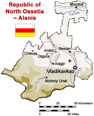
Map of North Ossetia, Russia (from mapping by US Dept of State - 2762 6-94 STATE (INR/GGI))
Originally uploaded to English Wikipedia by ChrisO.
| This image is a work of a United States Department of State employee, taken or made as part of that person's official duties. As a work of the U.S. federal government, the image is in the public domain per 17 U.S.C. § 101 and § 105 and the Department Copyright Information. |  |
ফাইলের ইতিহাস
যেকোনো তারিখ/সময়ে ক্লিক করে দেখুন ফাইলটি তখন কী অবস্থায় ছিল।
| তারিখ/সময় | সংক্ষেপচিত্র | মাত্রা | ব্যবহারকারী | মন্তব্য | |
|---|---|---|---|---|---|
| বর্তমান | ১৩:৫০, ৬ এপ্রিল ২০০৫ | | ৩০৪ × ৩৭৭ (২৩ কিলোবাইট) | Dbenbenn | Reverted to earlier revision |
| ১৩:৫০, ৬ এপ্রিল ২০০৫ |  | ৩০০ × ৩৩০ (৩৯ কিলোবাইট) | Dbenbenn | original version, uploaded by en:User:ChrisO at 12:19, 1 Sep 2004 | |
| ১২:৫১, ২৯ মার্চ ২০০৫ |  | ৩০৪ × ৩৭৭ (২৩ কিলোবাইট) | Fbd~commonswiki | Image from the en.wikipedia. {{PD-USGov}} |
সংযোগসমূহ
নিচের পৃষ্ঠা(গুলো) থেকে এই ছবিতে সংযোগ আছে:
ফাইলের বৈশ্বিক ব্যবহার
নিচের অন্যান্য উইকিগুলো এই ফাইলটি ব্যবহার করে:
- ar.wikipedia.org-এ ব্যবহার
- ceb.wikipedia.org-এ ব্যবহার
- cy.wikipedia.org-এ ব্যবহার
- da.wikipedia.org-এ ব্যবহার
- de.wikipedia.org-এ ব্যবহার
- en.wikinews.org-এ ব্যবহার
- es.wikipedia.org-এ ব্যবহার
- fa.wikipedia.org-এ ব্যবহার
- fr.wikipedia.org-এ ব্যবহার
- he.wikipedia.org-এ ব্যবহার
- hi.wikipedia.org-এ ব্যবহার
- hr.wikipedia.org-এ ব্যবহার
- id.wikipedia.org-এ ব্যবহার
- io.wikipedia.org-এ ব্যবহার
- is.wikipedia.org-এ ব্যবহার
- it.wikipedia.org-এ ব্যবহার
- ja.wikipedia.org-এ ব্যবহার
- jv.wikipedia.org-এ ব্যবহার
- ka.wiktionary.org-এ ব্যবহার
- ko.wikipedia.org-এ ব্যবহার
- mk.wikipedia.org-এ ব্যবহার
- nl.wikipedia.org-এ ব্যবহার
- nn.wikipedia.org-এ ব্যবহার
- no.wikipedia.org-এ ব্যবহার
- pt.wikipedia.org-এ ব্যবহার
- sh.wikipedia.org-এ ব্যবহার
- sr.wikipedia.org-এ ব্যবহার
- tr.wikipedia.org-এ ব্যবহার
- vep.wikipedia.org-এ ব্যবহার
- zh-min-nan.wikipedia.org-এ ব্যবহার
- zh.wikipedia.org-এ ব্যবহার
এই ফাইলের অন্যান্য বৈশ্বিক ব্যবহার দেখুন।