চিত্র:North Indian cyclone tracks 1970-2005.jpg

পূর্ণ রেজোলিউশন (২,৯৪৩ × ১,৬৭১ পিক্সেল, ফাইলের আকার: ১.১৯ মেগাবাইট, এমআইএমই ধরন: image/jpeg)
| এই ফাইলটি উইকিমিডিয়া কমন্স থেকে নেওয়া। সেখানের বর্ণনা পাতার বিস্তারিত নিম্নে দেখানো হলো। (সম্পাদনা)
|
সারাংশ
| Saffir-Simpson Hurricane Scale | ||||||
| TD | TS | 1 | 2 | 3 | 4 | 5 |
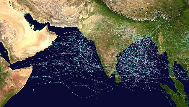
This map shows the tracks of all Tropical cyclones which formed in the north Indian Ocean, or moved into that basin from the northwest Pacific Ocean, from 1970 to 2005. The points show the locations of the storms at six-hourly intervals and use the color scheme shown to the right from Saffir-Simpson Hurricane Scale. Gray points denote unknown strength storms.
লাইসেন্স প্রদান
Created using User:jdorje/Tracks by Nilfanion on 2006-08-16. Background image from Image:Whole_world_-_land_and_oceans.jpg (NASA).
Tracking data for storms is from the Joint Typhoon Warning Center.[1]
| আমি, এই কাজের স্বত্বাধিকারী, এতদ্দ্বারা আমি এই কাজকে পাবলিক ডোমেইন লাইসেন্সের আওতায় প্রকাশ করলাম। এটি বিশ্বব্যাপী প্রযোজ্য হবে। কিছু দেশে এটি আইনত সিদ্ধ নাও হতে পারে, যদি তাই হয়: আমি যে-কাউকে এই কাজটি যেকোনো উদ্দেশ্যে, বিনাশর্তে ব্যবহারের অনুমতি প্রদান করছি, যদি না সেই শর্তগুলো আইনত প্রয়োজনীয় হয়। |
ফাইলের ইতিহাস
যেকোনো তারিখ/সময়ে ক্লিক করে দেখুন ফাইলটি তখন কী অবস্থায় ছিল।
| তারিখ/সময় | সংক্ষেপচিত্র | মাত্রা | ব্যবহারকারী | মন্তব্য | |
|---|---|---|---|---|---|
| বর্তমান | ১৫:০৮, ১৬ আগস্ট ২০০৬ | | ২,৯৪৩ × ১,৬৭১ (১.১৯ মেগাবাইট) | Nilfanion | == Summary == {|align="{{{align|right}}}" border="0" cellspacing="0" cellpadding="0" style="background:transparent;text-align:center" |- |colspan="7" nowrap="nowrap"| <small>Saffir-Simpson Hurricane Scale</small> |- |s |
সংযোগসমূহ
নিচের পৃষ্ঠা(গুলো) থেকে এই ছবিতে সংযোগ আছে:
ফাইলের বৈশ্বিক ব্যবহার
নিচের অন্যান্য উইকিগুলো এই ফাইলটি ব্যবহার করে:
- de.wikipedia.org-এ ব্যবহার
- en.wikipedia.org-এ ব্যবহার
- fa.wikipedia.org-এ ব্যবহার
- id.wikipedia.org-এ ব্যবহার
- pt.wikipedia.org-এ ব্যবহার
- simple.wikipedia.org-এ ব্যবহার
- ta.wikipedia.org-এ ব্যবহার
- uk.wikipedia.org-এ ব্যবহার
- zh.wikipedia.org-এ ব্যবহার
- 2006年北印度洋氣旋季
- 2007年北印度洋氣旋季
- 2008年北印度洋氣旋季
- Portal:熱帶氣旋
- Portal:熱帶氣旋/風季
- 2009年北印度洋氣旋季
- 2010年北印度洋氣旋季
- 北印度洋氣旋季
- Template:North Indian Ocean cyclone seasons
- 2012年北印度洋氣旋季
- 2011年北印度洋氣旋季
- 2013年北印度洋氣旋季
- 2005年北印度洋氣旋季
- 2004年北印度洋氣旋季
- 2003年北印度洋氣旋季
- 2002年北印度洋氣旋季
- 2014年北印度洋氣旋季
- 2001年北印度洋氣旋季
- 2000年北印度洋氣旋季
- 1999年北印度洋氣旋季
- 2015年北印度洋氣旋季
- 1998年北印度洋氣旋季
- 1997年北印度洋氣旋季
- 1996年北印度洋氣旋季
- 1995年北印度洋氣旋季
- 1994年北印度洋氣旋季
- 1993年北印度洋氣旋季
- 1992年北印度洋氣旋季
- 1991年北印度洋氣旋季
- 1990年北印度洋氣旋季
- 2016年北印度洋氣旋季
- 2017年北印度洋氣旋季
- 2018年北印度洋氣旋季
- 2019年北印度洋氣旋季
- 2020年北印度洋氣旋季
- 2021年北印度洋氣旋季
- 2022年北印度洋氣旋季
- 2023年北印度洋氣旋季
- 2024年北印度洋氣旋季