চিত্র:Mapa Geografico de America Meridional (1790).jpg
এই প্রাকদর্শনের আকার: ৪২৪ × ৫৯৯ পিক্সেল। অন্যান্য আকারসমূহ: ১৭০ × ২৪০ পিক্সেল | ৩৩৯ × ৪৮০ পিক্সেল | ৫৪৩ × ৭৬৮ পিক্সেল | ১,০৫৯ × ১,৪৯৭ পিক্সেল।
পূর্ণ রেজোলিউশন (১,০৫৯ × ১,৪৯৭ পিক্সেল, ফাইলের আকার: ৫৫৮ কিলোবাইট, এমআইএমই ধরন: image/jpeg)
| এই ফাইলটি উইকিমিডিয়া কমন্স থেকে নেওয়া। সেখানের বর্ণনা পাতার বিস্তারিত নিম্নে দেখানো হলো। (সম্পাদনা)
|
সারাংশ
| বিবরণ |
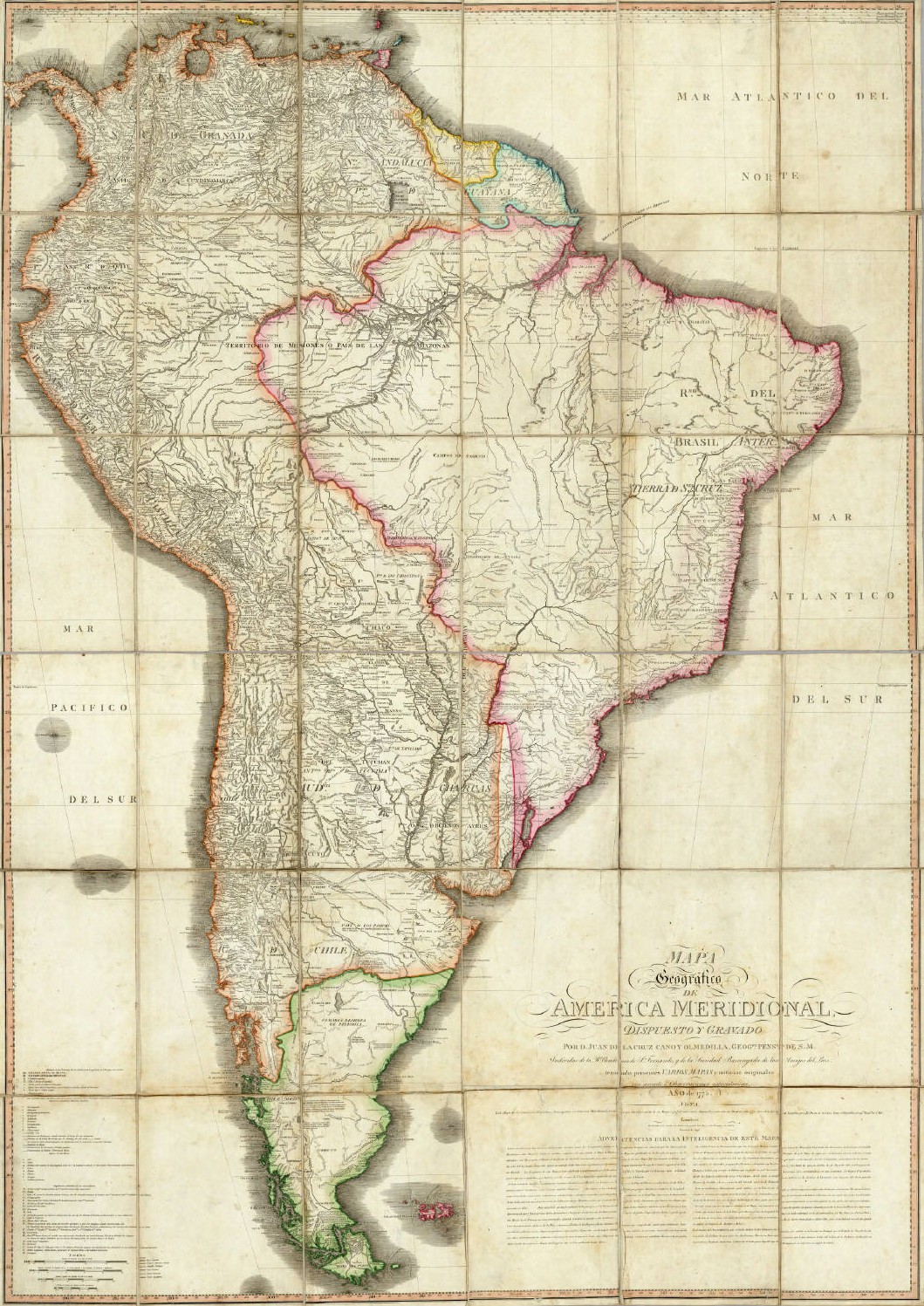
English: Geographical Map of South America, Drawn and Engraved by Mr. Juan de la Cruz Cano y Olmedilla, Geographer to His Majesty...
Español: Mapa Geografico de America Meridional, dispuesto y gravado por D. Juan de la Cruz Cano y Olmedilla, Geogfo. Pensdo. de S. M. Individuo de la R. Academia de Sn. Fernando, y da la Sociedad Bascongada de los Amigos del Pais, teniendo presentes Varios Mapas y noticias originales con arreglo a Observaciones astronómicas (Año 1775.) Londres, Publicado por William Faden, Geografo del Rey, y del Principe de Gales, Enero 1 de 1799. |
||||||||||||||||||||||
| তারিখ | 1775, reprinted 1799 | ||||||||||||||||||||||
| উৎস | অজানা | ||||||||||||||||||||||
| লেখক |
|
||||||||||||||||||||||
| অন্যান্য সংস্করণ |
|
||||||||||||||||||||||
.jpg)
.jpg?uselang=bn)
.jpg&action=edit)
লাইসেন্স প্রদান
|
This is a faithful photographic reproduction of a two-dimensional, public domain work of art. The work of art itself is in the public domain for the following reason:
The official position taken by the Wikimedia Foundation is that "faithful reproductions of two-dimensional public domain works of art are public domain".
This photographic reproduction is therefore also considered to be in the public domain in the United States. In other jurisdictions, re-use of this content may be restricted; see Reuse of PD-Art photographs for details. | ||||
ফাইলের ইতিহাস
যেকোনো তারিখ/সময়ে ক্লিক করে দেখুন ফাইলটি তখন কী অবস্থায় ছিল।
| তারিখ/সময় | সংক্ষেপচিত্র | মাত্রা | ব্যবহারকারী | মন্তব্য | |
|---|---|---|---|---|---|
| বর্তমান | ০২:৩৭, ১৪ মে ২০০৬ | | ১,০৫৯ × ১,৪৯৭ (৫৫৮ কিলোবাইট) | Fbaltra | |
| ০২:৩২, ১৪ মে ২০০৬ |  | ১,০৯৭ × ১,৫৩৬ (৩৬০ কিলোবাইট) | Fbaltra | == Summary == Mapa Geografico de America Meridional de Juan de la Cruz Cano y Olmedilla, 1790. Publicado en 1799 por William Faden, Londres. == Licensing == {{PD-Art}} Category:Historical maps of South America Category:Historical maps of Chile |
সংযোগসমূহ
এই ফাইল ব্যবহার করে এমন কোনো পাতা নেই।
ফাইলের বৈশ্বিক ব্যবহার
নিচের অন্যান্য উইকিগুলো এই ফাইলটি ব্যবহার করে:
- de.wikipedia.org-এ ব্যবহার
- en.wikipedia.org-এ ব্যবহার
- es.wikipedia.org-এ ব্যবহার
- it.wikipedia.org-এ ব্যবহার
- roa-tara.wikipedia.org-এ ব্যবহার
.jpg)