চিত্র:Map indicating Prince of Wales Strait, Northwest Territories, Canada.png
Map_indicating_Prince_of_Wales_Strait,_Northwest_Territories,_Canada.png (৪২৮ × ৩৮০ পিক্সেল, ফাইলের আকার: ৬৬ কিলোবাইট, এমআইএমই ধরন: image/png)
| এই ফাইলটি উইকিমিডিয়া কমন্স থেকে নেওয়া। সেখানের বর্ণনা পাতার বিস্তারিত নিম্নে দেখানো হলো। (সম্পাদনা)
|
সারাংশ
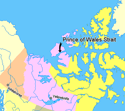
Map indicating Prince of Wales Strait, Northwest Territories, Canada.
© Her Majesty the Queen in Right of Canada, Department of Natural Resources. All rights reserved.
Licence Agreement

|
This locator map image could be re-created using vector graphics as an SVG file. This has several advantages; see Commons:Media for cleanup for more information. If an SVG form of this image is available, please upload it and afterwards replace this template with
{{vector version available|new image name}}.
It is recommended to name the SVG file “Map indicating Prince of Wales Strait, Northwest Territories, Canada.svg”—then the template Vector version available (or Vva) does not need the new image name parameter. |
লাইসেন্স প্রদান

|
The copyright holder of this work allows anyone to use it for any purpose including unrestricted redistribution, commercial use, and modification.
Usage notes:
|
ফাইলের ইতিহাস
যেকোনো তারিখ/সময়ে ক্লিক করে দেখুন ফাইলটি তখন কী অবস্থায় ছিল।
| তারিখ/সময় | সংক্ষেপচিত্র | মাত্রা | ব্যবহারকারী | মন্তব্য | |
|---|---|---|---|---|---|
| বর্তমান | ২৩:২২, ২০ মার্চ ২০০৬ | | ৪২৮ × ৩৮০ (৬৬ কিলোবাইট) | David Kernow~commonswiki | Map indicating Prince of Wales Strait, Northwest Territories, Canada. {{legend|#ffff66|Nunavut}} {{legend|#ffccff|Northwest Territories}} {{legend|#ffcc99|Yukon Territory}} {{legend|#ffffcc|Regions outside Canada (Alaska, Gre |
সংযোগসমূহ
নিচের পৃষ্ঠা(গুলো) থেকে এই ছবিতে সংযোগ আছে:
ফাইলের বৈশ্বিক ব্যবহার
নিচের অন্যান্য উইকিগুলো এই ফাইলটি ব্যবহার করে:
- az.wikipedia.org-এ ব্যবহার
- de.wikipedia.org-এ ব্যবহার
- en.wikipedia.org-এ ব্যবহার
- es.wikipedia.org-এ ব্যবহার
- fr.wikipedia.org-এ ব্যবহার
- he.wikipedia.org-এ ব্যবহার
- id.wikipedia.org-এ ব্যবহার
- ja.wikipedia.org-এ ব্যবহার
- ko.wikipedia.org-এ ব্যবহার
- lt.wikipedia.org-এ ব্যবহার
- nl.wikipedia.org-এ ব্যবহার
- pl.wikipedia.org-এ ব্যবহার
- pt.wikipedia.org-এ ব্যবহার
- ru.wikipedia.org-এ ব্যবহার
- tr.wikipedia.org-এ ব্যবহার
- uk.wikipedia.org-এ ব্যবহার
- zh.wikipedia.org-এ ব্যবহার