চিত্র:Mameyes.jpg
এর চেয়ে বেশি রেজোলিউশন লভ্য নয়।
Mameyes.jpg (৮০০ × ৫৩৯ পিক্সেল, ফাইলের আকার: ২১৩ কিলোবাইট, এমআইএমই ধরন: image/jpeg)
| এই ফাইলটি উইকিমিডিয়া কমন্স থেকে নেওয়া। সেখানের বর্ণনা পাতার বিস্তারিত নিম্নে দেখানো হলো। (সম্পাদনা)
|
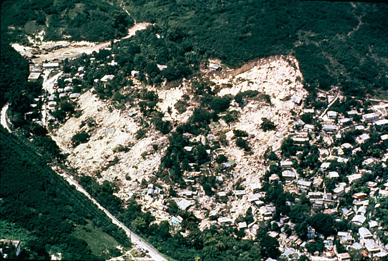
| বিবরণ |
English: Aerial picture of the Mameyes landslide |
|||
| উৎস | http://www.ngdc.noaa.gov/hazardimages/picture/show/1549 | |||
| লেখক | R.W. Jibson, U.S. Geological Survey | |||
| অনুমতি (এ ফাইলের পুনঃব্যবহার) |
|
|||
| অন্যান্য সংস্করণ |
Originally from en.wikipedia; description page is (was) here * 11:39, 28 May 2006 [[:en:User:Nilfanion|Nilfanion]] 800×539 (218,573 bytes) * 23:43, 28 November 2005 [[:en:User:Thief12|Thief12]] 400×270 (55,216 bytes) <span class="comment">(http://www.linktopr.com/mameyes.html Aerial picture of the Mameyes landslide Taken by: R.W. Jibson, U.S. Geological Survey)</span> |
ফাইলের ইতিহাস
যেকোনো তারিখ/সময়ে ক্লিক করে দেখুন ফাইলটি তখন কী অবস্থায় ছিল।
| তারিখ/সময় | সংক্ষেপচিত্র | মাত্রা | ব্যবহারকারী | মন্তব্য | |
|---|---|---|---|---|---|
| বর্তমান | ২০:০৭, ১৪ আগস্ট ২০০৬ | | ৮০০ × ৫৩৯ (২১৩ কিলোবাইট) | Nilfanion | {{Information| |Description= Aerial picture of the Mameyes landslide Taken by: R.W. Jibson, U.S. Geological Survey |Source=http://landslides.usgs.gov/learningeducation/imagepreviews.php |Date= |Author=Users Nilfanion, [[:en:User:Th |
সংযোগসমূহ
নিচের পৃষ্ঠা(গুলো) থেকে এই ছবিতে সংযোগ আছে:
ফাইলের বৈশ্বিক ব্যবহার
নিচের অন্যান্য উইকিগুলো এই ফাইলটি ব্যবহার করে:
- as.wikipedia.org-এ ব্যবহার
- bs.wikipedia.org-এ ব্যবহার
- en.wikipedia.org-এ ব্যবহার
- fa.wikipedia.org-এ ব্যবহার
- hu.wikipedia.org-এ ব্যবহার
- ig.wikipedia.org-এ ব্যবহার
- ja.wikipedia.org-এ ব্যবহার
- kn.wikipedia.org-এ ব্যবহার
- mr.wikipedia.org-এ ব্যবহার
- sh.wikipedia.org-এ ব্যবহার
- sr.wikipedia.org-এ ব্যবহার
- sv.wikipedia.org-এ ব্যবহার
- ta.wikipedia.org-এ ব্যবহার
- uk.wikipedia.org-এ ব্যবহার