চিত্র:Lakshmi Planum and Siddons Patera PIA00240.jpg

এই প্রাকদর্শনের আকার: ৫০৭ × ৫৯৯ পিক্সেল। অন্যান্য আকারসমূহ: ২০৩ × ২৪০ পিক্সেল | ৪০৬ × ৪৮০ পিক্সেল | ৬৫০ × ৭৬৮ পিক্সেল | ৮৬৬ × ১,০২৪ পিক্সেল | ১,৭৩২ × ২,০৪৮ পিক্সেল | ৩,০৭৩ × ৩,৬৩৩ পিক্সেল।
পূর্ণ রেজোলিউশন (৩,০৭৩ × ৩,৬৩৩ পিক্সেল, ফাইলের আকার: ৩.৭৬ মেগাবাইট, এমআইএমই ধরন: image/jpeg)
| এই ফাইলটি উইকিমিডিয়া কমন্স থেকে নেওয়া। সেখানের বর্ণনা পাতার বিস্তারিত নিম্নে দেখানো হলো। (সম্পাদনা)
|
সারাংশ
| বিবরণ |
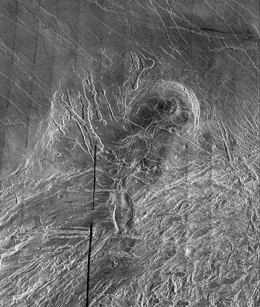
English: This image is a full-resolution mosaic of several Magellan images and is centered at 61 degrees north latitude and 341 degrees east longitude. The image is 250 kilometers wide (150 miles). The radar smooth region in the northern part of the image is Lakshmi Planum, a high plateau region roughly 3.5 kilometers (2.2 miles) above the mean planetary radius. Lakshmi Planum is ringed by intensely deformed terrain, some of which is shown in the southern portion of the image and is called Clotho Tessera. The 64-kilometer (40 mile) diameter circular feature in the image is a depression called Siddons and may be a volcanic caldera. This view is supported by the collapsed lava tubes surrounding the feature. By carefully studying this and other surrounding images scientists hope to discover what tectonic and volcanic processes formed this complex region. The solid black parts of the image represent data gaps that may be filled in by the Magellan extended mission. |
| উৎস | http://photojournal.jpl.nasa.gov/catalog/PIA00240 |
| লেখক | Galileo probe |
লাইসেন্স প্রদান
| এই ফাইলটি পাবলিক ডোমেইনে আছে কারণ এটি শুধুমাত্র নাসা কর্তৃক নির্মিত হয়েছিল। নাসার কপিরাইট নীতি হচ্ছে যে "নাসা কর্তৃক উল্লেখ না থাকলে নাসার উপাদান কপিরাইট দ্বারা সুরক্ষিত নয়"। (Template:PD-USGov, নাসার কপিরাইট নীতির পাতা অথবা জেপিএল চিত্র ব্যবহারের নীতি দেখুন।) | ||
 |
সতর্কবার্তা:
|
ফাইলের ইতিহাস
যেকোনো তারিখ/সময়ে ক্লিক করে দেখুন ফাইলটি তখন কী অবস্থায় ছিল।
| তারিখ/সময় | সংক্ষেপচিত্র | মাত্রা | ব্যবহারকারী | মন্তব্য | |
|---|---|---|---|---|---|
| বর্তমান | ০৫:৩৮, ৭ এপ্রিল ২০০৮ | | ৩,০৭৩ × ৩,৬৩৩ (৩.৭৬ মেগাবাইট) | Bryan Derksen | {{Information |Description={{en|This image is a full-resolution mosaic of several Magellan images and is centered at 61 degrees north latitude and 341 degrees east longitude. The image is 250 kilometers wide (150 miles). The radar smooth region in the nor |
সংযোগসমূহ
নিচের পৃষ্ঠা(গুলো) থেকে এই ছবিতে সংযোগ আছে:
ফাইলের বৈশ্বিক ব্যবহার
নিচের অন্যান্য উইকিগুলো এই ফাইলটি ব্যবহার করে:
- be.wikipedia.org-এ ব্যবহার
- cs.wikipedia.org-এ ব্যবহার
- fi.wikipedia.org-এ ব্যবহার
- fr.wikipedia.org-এ ব্যবহার
- hi.wikipedia.org-এ ব্যবহার
- hy.wikipedia.org-এ ব্যবহার
- ja.wikipedia.org-এ ব্যবহার
- nl.wikipedia.org-এ ব্যবহার
- ru.wikipedia.org-এ ব্যবহার
- sr.wikipedia.org-এ ব্যবহার
- ta.wikipedia.org-এ ব্যবহার
- uk.wikipedia.org-এ ব্যবহার
- zh.wikipedia.org-এ ব্যবহার