চিত্র:Jammu and Kashmir in 1946 map of India by National Geographic.jpg

এই প্রাকদর্শনের আকার: ৭৬৯ × ৫৯৯ পিক্সেল। অন্যান্য আকারসমূহ: ৩০৮ × ২৪০ পিক্সেল | ৬১৬ × ৪৮০ পিক্সেল | ৯৮৫ × ৭৬৮ পিক্সেল | ১,২৮০ × ৯৯৮ পিক্সেল | ১,৫৫১ × ১,২০৯ পিক্সেল।
পূর্ণ রেজোলিউশন (১,৫৫১ × ১,২০৯ পিক্সেল, ফাইলের আকার: ৪২৯ কিলোবাইট, এমআইএমই ধরন: image/jpeg)
| এই ফাইলটি উইকিমিডিয়া কমন্স থেকে নেওয়া। সেখানের বর্ণনা পাতার বিস্তারিত নিম্নে দেখানো হলো। (সম্পাদনা)
|
সারাংশ
| বিবরণ |
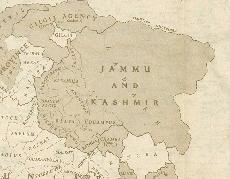
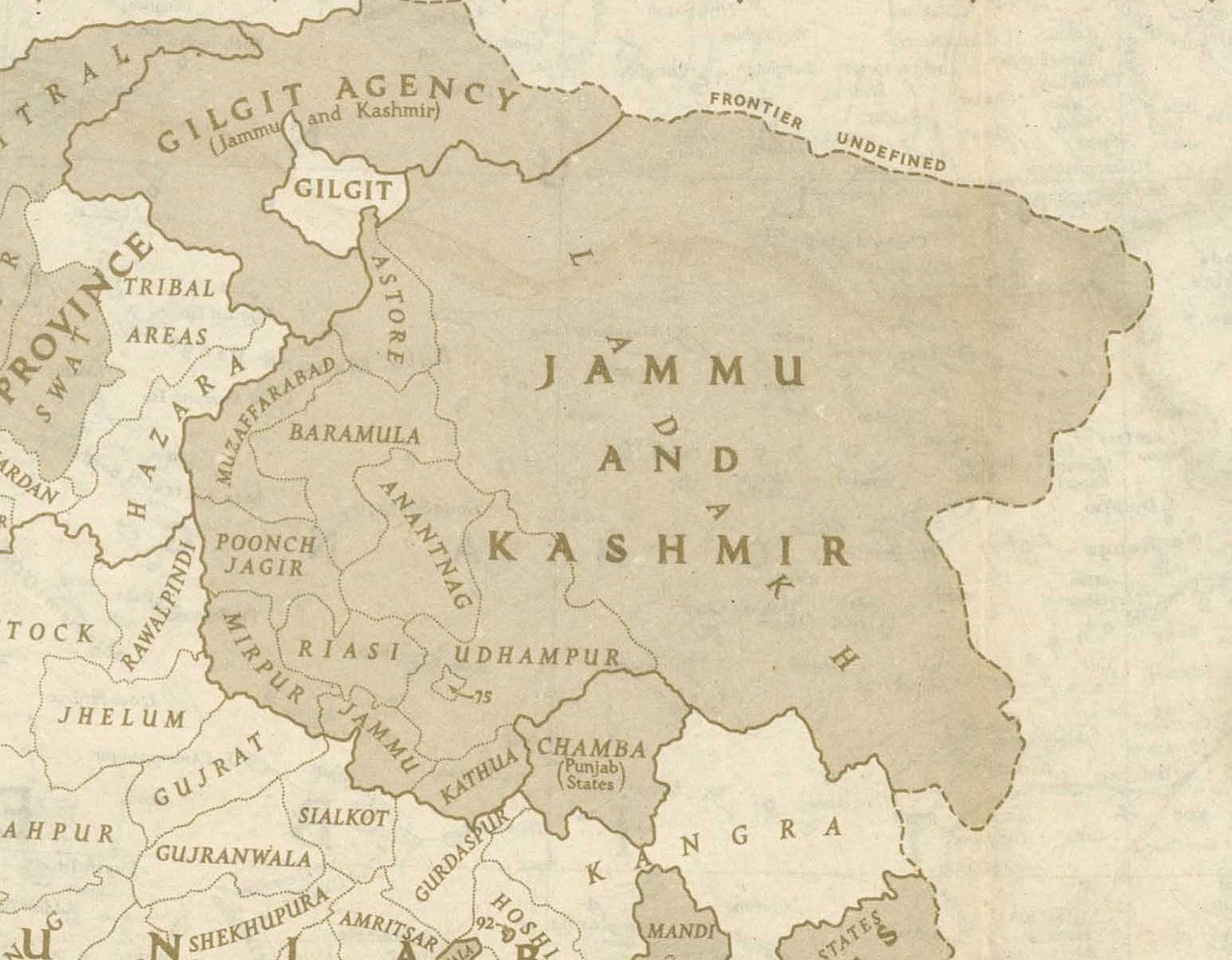
English: This is one of the last few maps of Jammu and Kashmir produced during the British Raj, just before the independence of India and Pakistan |
| তারিখ | |
| উৎস | http://pahar.in/wpfb-file/1946-political-subdivisions-of-india-by-national-geographic-jpg/ |
| লেখক | National Geographic |
| অন্যান্য সংস্করণ |

লাইসেন্স প্রদান
This media file is in the public domain in the United States. This applies to U.S. works where the copyright has expired, often because its first publication occurred prior to January 1, {{{year}}}, and if not then due to lack of notice or renewal. See this page for further explanation.
|
 | |
 |
This image might not be in the public domain outside of the United States; this especially applies in the countries and areas that do not apply the rule of the shorter term for US works, such as Canada, Mainland China (not Hong Kong or Macao), Germany, Mexico, and Switzerland. The creator and year of publication are essential information and must be provided. See Wikipedia:Public domain and Wikipedia:Copyrights for more details.
|
ফাইলের ইতিহাস
যেকোনো তারিখ/সময়ে ক্লিক করে দেখুন ফাইলটি তখন কী অবস্থায় ছিল।
| তারিখ/সময় | সংক্ষেপচিত্র | মাত্রা | ব্যবহারকারী | মন্তব্য | |
|---|---|---|---|---|---|
| বর্তমান | ২০:৪৮, ২১ অক্টোবর ২০২০ | | ১,৫৫১ × ১,২০৯ (৪২৯ কিলোবাইট) | Kautilya3 | Uploaded a work by National Geographic from http://pahar.in/wpfb-file/1946-political-subdivisions-of-india-by-national-geographic-jpg/ with UploadWizard |
সংযোগসমূহ
নিচের পৃষ্ঠা(গুলো) থেকে এই ছবিতে সংযোগ আছে:
ফাইলের বৈশ্বিক ব্যবহার
নিচের অন্যান্য উইকিগুলো এই ফাইলটি ব্যবহার করে:
- en.wikipedia.org-এ ব্যবহার
- Azad Kashmir
- Gilgit Agency
- History of Poonch District
- Talk:Sino-Indian border dispute
- Gilgit-Baltistan
- Elections in Jammu and Kashmir
- Ardagh–Johnson Line
- 1947 Jammu massacres
- User:Falcaorib
- Template:User J&K princely state
- Wikipedia:Userboxes/Location/Kashmir
- Forward policy (Sino-Indian conflict)
- 1837 Poonch Revolt
- 1947 Gilgit rebellion
- en.wikivoyage.org-এ ব্যবহার
- hi.wikipedia.org-এ ব্যবহার
- ko.wikipedia.org-এ ব্যবহার
- nl.wikipedia.org-এ ব্যবহার