চিত্র:Indian stream map.png
এই প্রাকদর্শনের আকার: ৮০০ × ৫৭৫ পিক্সেল। অন্যান্য আকারসমূহ: ৩২০ × ২৩০ পিক্সেল | ৬৪০ × ৪৬০ পিক্সেল | ১,০২৪ × ৭৩৬ পিক্সেল | ১,২৮০ × ৯২০ পিক্সেল | ১,৬১৭ × ১,১৬২ পিক্সেল।
পূর্ণ রেজোলিউশন (১,৬১৭ × ১,১৬২ পিক্সেল, ফাইলের আকার: ১৪৭ কিলোবাইট, এমআইএমই ধরন: image/png)
| এই ফাইলটি উইকিমিডিয়া কমন্স থেকে নেওয়া। সেখানের বর্ণনা পাতার বিস্তারিত নিম্নে দেখানো হলো। (সম্পাদনা)
|
সারাংশ
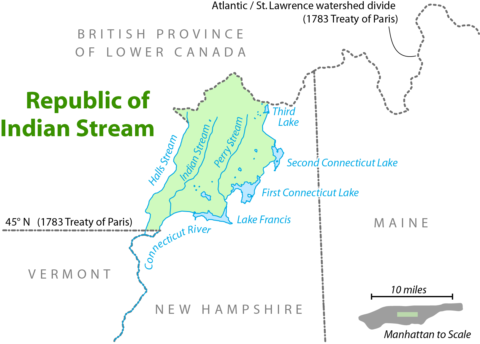
| বিবরণ | Map showing the location of the Republic of Indian Stream. I, Citynoise, am the creator of this map and hereby release it under the ShareAlike Attribution License. See www.radicalcartography.net for more. |
| তারিখ | ১৮ জুন ২০০৬ (মূল আপলোডের তারিখ) |
| উৎস | en.wikipedia থেকে কমন্সে স্থানান্তরিত করা হয়েছে। |
| লেখক |
মূল আপলোডকারী ছিলেন ইংরেজি উইকিপিডিয়া-এর Citynoise Later versions were uploaded by AnonMoos at en.wikipedia. |

|
This map image could be re-created using vector graphics as an SVG file. This has several advantages; see Commons:Media for cleanup for more information. If an SVG form of this image is available, please upload it and afterwards replace this template with
{{vector version available|new image name}}.
It is recommended to name the SVG file “Indian stream map.svg”—then the template Vector version available (or Vva) does not need the new image name parameter. |
লাইসেন্স প্রদান
এই ফাইলটি ক্রিয়েটিভ কমন্স অ্যাট্রিবিউশন-শেয়ার অ্যালাইক ২.৫ জেনেরিক লাইসেন্সের আওতায় লাইসেন্সকৃত।
- আপনি স্বাধীনভাবে:
- বণ্টন করতে পারেন – এ কাজটি অনুলিপি, বিতরণ এবং প্রেরণ করতে পারেন
- পুনঃমিশ্রণ করতে পারেন – কাজটি অভিযোজন করতে পারেন
- নিম্নের শর্তাবলীর ভিত্তিতে:
- স্বীকৃতিপ্রদান – আপনাকে অবশ্যই যথাযথ স্বীকৃতি প্রদান করতে হবে, লাইসেন্সের একটি লিঙ্ক সরবরাহ করতে হবে এবং কোনো পরিবর্তন হয়েছে কিনা তা নির্দেশ করতে হবে। আপনি যেকোনো যুক্তিসঙ্গত পদ্ধতিতে এটি করতে পারেন। কিন্তু এমন ভাবে নয়, যাতে প্রকাশ পায় যে লাইসেন্সধারী আপনাকে বা আপনার এই ব্যবহারের জন্য অনুমোদন দিয়েছে।
- একইভাবে বণ্টন – আপনি যদি কাজটি পুনঃমিশ্রণ, রুপান্তর, বা এর ওপর ভিত্তি করে নতুন সৃষ্টিকর্ম তৈরি করেন, তবে আপনাকে অবশ্যই আপনার অবদান একই লাইসেন্স বা একই রকমের লাইসেন্সের আওতায় বিতরণ করতে হবে।
মূল আপলোড লগ
মূল বিবরণ পাতাটি এখানে ছিল। নিম্নলিখিত সকল ব্যবহারকারীর নাম en.wikipedia-এ উল্লেখ করা ছিল।
- 2006-09-28 11:01 AnonMoos 754×548×8 (92671 bytes) trimming excessive margins (whitespace), increasing PNG compression...
- 2006-06-27 00:48 Citynoise 800×600×8 (115636 bytes) fixed error in date of Treaty of Paris.
- 2006-06-18 03:09 Citynoise 800×600×8 (119474 bytes) Map showing the location of the Republic of Indian Stream. I, Citynoise, am the creator of this map and hereby release it under the ShareAlike Attribution License. See www.radicalcartography.net for more. Added scale.
- 2006-06-18 02:43 Citynoise 800×588×8 (118009 bytes) Map showing the location of the Republic of Indian Stream. I, Citynoise, am the creator of this map and hereby release it under the ShareAlike Attribution License. See www.radicalcartography.net for more.
ফাইলের ইতিহাস
যেকোনো তারিখ/সময়ে ক্লিক করে দেখুন ফাইলটি তখন কী অবস্থায় ছিল।
| তারিখ/সময় | সংক্ষেপচিত্র | মাত্রা | ব্যবহারকারী | মন্তব্য | |
|---|---|---|---|---|---|
| বর্তমান | ১৭:৫৬, ৬ সেপ্টেম্বর ২০১৬ | | ১,৬১৭ × ১,১৬২ (১৪৭ কিলোবাইট) | Citynoise | Corrected name of Lower Canada |
| ১৭:০৩, ১০ এপ্রিল ২০০৭ |  | ৭৫৪ × ৫৪৮ (৯০ কিলোবাইট) | Liftarn | {{Information |Description=Map showing the location of the Republic of Indian Stream. I, Citynoise, am the creator of this map and hereby release it under the ShareAlike Attribution License. See www.radicalcartography.net for more. |Source=Originally fr |
সংযোগসমূহ
নিচের পৃষ্ঠা(গুলো) থেকে এই ছবিতে সংযোগ আছে:
ফাইলের বৈশ্বিক ব্যবহার
নিচের অন্যান্য উইকিগুলো এই ফাইলটি ব্যবহার করে:
- ar.wikipedia.org-এ ব্যবহার
- de.wikipedia.org-এ ব্যবহার
- en.wikipedia.org-এ ব্যবহার
- en.wiktionary.org-এ ব্যবহার
- es.wikipedia.org-এ ব্যবহার
- et.wikipedia.org-এ ব্যবহার
- fr.wikipedia.org-এ ব্যবহার
- ja.wikipedia.org-এ ব্যবহার
- nl.wikipedia.org-এ ব্যবহার
- pt.wikipedia.org-এ ব্যবহার
- ru.wikipedia.org-এ ব্যবহার
- www.wikidata.org-এ ব্যবহার
- zh.wikipedia.org-এ ব্যবহার