চিত্র:Iceberg A22A, South Atlantic Ocean.jpg

এই প্রাকদর্শনের আকার: ৮০০ × ৫৩০ পিক্সেল। অন্যান্য আকারসমূহ: ৩২০ × ২১২ পিক্সেল | ৬৪০ × ৪২৪ পিক্সেল | ১,০২৪ × ৬৭৮ পিক্সেল | ১,২৮০ × ৮৪৮ পিক্সেল | ২,৩৪৫ × ১,৫৫৩ পিক্সেল।
পূর্ণ রেজোলিউশন (২,৩৪৫ × ১,৫৫৩ পিক্সেল, ফাইলের আকার: ৭৯৩ কিলোবাইট, এমআইএমই ধরন: image/jpeg)
| এই ফাইলটি উইকিমিডিয়া কমন্স থেকে নেওয়া। সেখানের বর্ণনা পাতার বিস্তারিত নিম্নে দেখানো হলো। (সম্পাদনা)
|
সারাংশ
| বিবরণ |
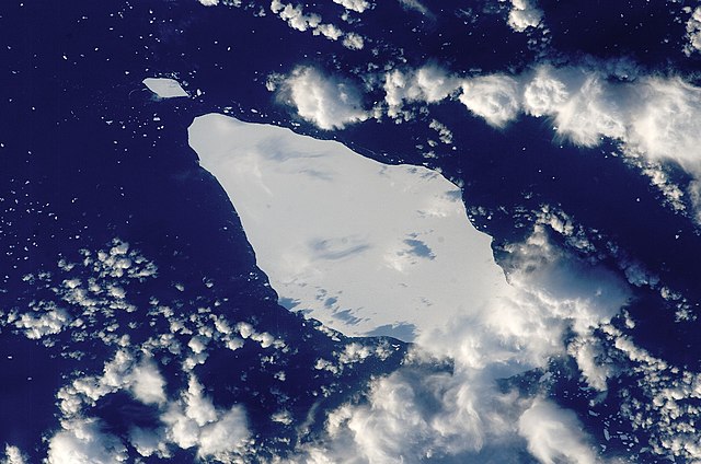
English: This astronaut photograph illustrates the remains of a giant iceberg—designated A22A— that broke off Antarctica in 2002. The iceberg was photographed at a location of 49.9 degrees south latitude, 23.8 degrees west longitude, which is about a third of the distance from South America towards Cape Town, South Africa. A22A is one of the largest icebergs to drift as far north as 50 degrees south latitude, bringing it beneath the daylight path of the International Space Station (ISS). Crew members aboard the ISS were able to locate the ice mass and photograph it, despite the great masses of clouds that often accompany winter storms in the Southern Ocean. The crew’s viewing angle was oblique (not looking straight down) from a point to the west of the berg, and the time of day was early afternoon, as shown by the orientation of the cloud shadows. Dimensions of A22A in early June were 49.9 by 23.4 kilometres, giving it an area of 622 square kilometres, or seven times the area of Manhattan Island.
|
||||||||||||||||||||||||||||||||||||||||||||||||||
| তারিখ | |||||||||||||||||||||||||||||||||||||||||||||||||||
| উৎস | {{URL|example.com|optional display text}} | ||||||||||||||||||||||||||||||||||||||||||||||||||
| লেখক | Image provided by the ISS Crew Earth Observations experiment and the Image Science & Analysis Laboratory, NASA - Johnson Space Center. | ||||||||||||||||||||||||||||||||||||||||||||||||||
| বস্তুর অবস্থান | | এটি এবং অন্যান্য ছবি তাদের অবস্থানের উপর: ওপেনস্ট্রিটম্যাপ |
|---|
This image or video was catalogued by Johnson Space Center of the United States National Aeronautics and Space Administration (NASA) under Photo ID: ISS015-E-10125. This tag does not indicate the copyright status of the attached work. A normal copyright tag is still required. See Commons:Licensing. Other languages:
|
লাইসেন্স প্রদান
| এই ফাইলটি পাবলিক ডোমেইনে আছে কারণ এটি শুধুমাত্র নাসা কর্তৃক নির্মিত হয়েছিল। নাসার কপিরাইট নীতি হচ্ছে যে "নাসা কর্তৃক উল্লেখ না থাকলে নাসার উপাদান কপিরাইট দ্বারা সুরক্ষিত নয়"। (Template:PD-USGov, নাসার কপিরাইট নীতির পাতা অথবা জেপিএল চিত্র ব্যবহারের নীতি দেখুন।) | ||
 |
সতর্কবার্তা:
|
ফাইলের ইতিহাস
যেকোনো তারিখ/সময়ে ক্লিক করে দেখুন ফাইলটি তখন কী অবস্থায় ছিল।
| তারিখ/সময় | সংক্ষেপচিত্র | মাত্রা | ব্যবহারকারী | মন্তব্য | |
|---|---|---|---|---|---|
| বর্তমান | ১৫:২৫, ২২ মার্চ ২০১৩ | | ২,৩৪৫ × ১,৫৫৩ (৭৯৩ কিলোবাইট) | Julian Herzog | Higher resolution and quality |
| ১৯:৫৪, ৫ জুলাই ২০০৯ |  | ১,০০০ × ১,০০০ (৩৭৬ কিলোবাইট) | Originalwana | {{Information |Description={{en|1=This astronaut photograph illustrates the remains of a giant iceberg—designated A22A— that broke off Antarctica in 2002. The iceberg was photographed at a location of 49.9 degrees south latitude, 23.8 degrees west lon |
সংযোগসমূহ
নিচের পৃষ্ঠা(গুলো) থেকে এই ছবিতে সংযোগ আছে:
ফাইলের বৈশ্বিক ব্যবহার
নিচের অন্যান্য উইকিগুলো এই ফাইলটি ব্যবহার করে:
- ar.wikipedia.org-এ ব্যবহার
- az.wikipedia.org-এ ব্যবহার
- cy.wikipedia.org-এ ব্যবহার
- en.wikipedia.org-এ ব্যবহার
- eo.wikipedia.org-এ ব্যবহার
- it.wikipedia.org-এ ব্যবহার
- it.wikibooks.org-এ ব্যবহার
- it.wikiversity.org-এ ব্যবহার
- la.wikipedia.org-এ ব্যবহার
- mk.wikipedia.org-এ ব্যবহার
- pt.wikipedia.org-এ ব্যবহার
- sl.wikipedia.org-এ ব্যবহার
- ta.wikipedia.org-এ ব্যবহার
- ta.wiktionary.org-এ ব্যবহার
- th.wikipedia.org-এ ব্যবহার