চিত্র:ISS018-E-7727 NASA Asau Savai'i, Samoa.jpg

এই প্রাকদর্শনের আকার: ৮০০ × ৫৩২ পিক্সেল। অন্যান্য আকারসমূহ: ৩২০ × ২১৩ পিক্সেল | ৬৪০ × ৪২৬ পিক্সেল | ১,০২৪ × ৬৮১ পিক্সেল | ১,২৮০ × ৮৫১ পিক্সেল | ২,৫৬০ × ১,৭০৩ পিক্সেল | ৪,৩১২ × ২,৮৬৮ পিক্সেল।
পূর্ণ রেজোলিউশন (৪,৩১২ × ২,৮৬৮ পিক্সেল, ফাইলের আকার: ২.৯৭ মেগাবাইট, এমআইএমই ধরন: image/jpeg)
| এই ফাইলটি উইকিমিডিয়া কমন্স থেকে নেওয়া। সেখানের বর্ণনা পাতার বিস্তারিত নিম্নে দেখানো হলো। (সম্পাদনা)
|
সারাংশ
| বিবরণ |
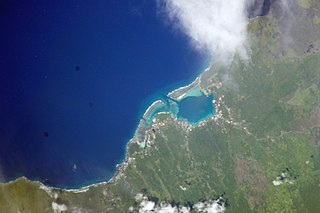
English: Savai'i island, north west coast, reefs, Asau taken by NASA at an altitude of 192 nautical miles (356 km)
Gagana Samoa: Le Itu Asau, Savai'i (le ata mai NASA)
Русский: Район Асау на острове Савайи в Самоа. Фото с сайта НАСА. |
| তারিখ | |
| উৎস |
<http://eol.jsc.nasa.gov/scripts/sseop/photo.pl?mission=ISS018&roll=E&frame=7727> (). Image Science and Analysis Laboratory, NASA-Johnson Space Center. "The Gateway to Astronaut Photography of Earth." |
| লেখক |
NASA
|
| ক্যামেরার অবস্থান | | এটি এবং অন্যান্য ছবি তাদের অবস্থানের উপর: ওপেনস্ট্রিটম্যাপ |
|---|
This image or video was catalogued by Kennedy Space Center of the United States National Aeronautics and Space Administration (NASA) under Photo ID: ISS018-E-7727. This tag does not indicate the copyright status of the attached work. A normal copyright tag is still required. See Commons:Licensing. Other languages:
|
লাইসেন্স প্রদান
This file is in the public domain in the United States because it was created by the Image Science & Analysis Laboratory, of the NASA Johnson Space Center. NASA copyright policy states that "NASA material is not protected by copyright unless noted". (NASA media use guidelines or Conditions of Use of Astronaut Photographs).
Photo source: ISS018-E-7727.
|
ফাইলের ইতিহাস
যেকোনো তারিখ/সময়ে ক্লিক করে দেখুন ফাইলটি তখন কী অবস্থায় ছিল।
| তারিখ/সময় | সংক্ষেপচিত্র | মাত্রা | ব্যবহারকারী | মন্তব্য | |
|---|---|---|---|---|---|
| বর্তমান | ২২:৪৮, ২৬ মে ২০১৩ | | ৪,৩১২ × ২,৮৬৮ (২.৯৭ মেগাবাইট) | Ras67 | new rendered from NASA's raw image file, 180 degree rotated |
| ১৩:০৩, ২৫ জানুয়ারি ২০১০ |  | ৬৪০ × ৪৩৭ (৫০ কিলোবাইট) | Teinesavaii | {{Information |Description={{en|1=Savai'i island, north west coast, reefs, Asau taken by NASA at an altitude of 192 nautical miles (356 km)}} |Source=<http://eol.jsc.nasa.gov/scripts/sseop/photo.pl?mission=ISS018&roll=E&frame=7727> (). Image Science and A |
সংযোগসমূহ
নিচের পৃষ্ঠা(গুলো) থেকে এই ছবিতে সংযোগ আছে:
ফাইলের বৈশ্বিক ব্যবহার
নিচের অন্যান্য উইকিগুলো এই ফাইলটি ব্যবহার করে:
- en.wikipedia.org-এ ব্যবহার
- it.wikipedia.org-এ ব্যবহার
- mrj.wikipedia.org-এ ব্যবহার
- sk.wikipedia.org-এ ব্যবহার
- uk.wikipedia.org-এ ব্যবহার
- ur.wikipedia.org-এ ব্যবহার
- www.wikidata.org-এ ব্যবহার