চিত্র:GreatLakes.A2005027.1635.250m.jpg

এই প্রাকদর্শনের আকার: ৭৮০ × ৬০০ পিক্সেল। অন্যান্য আকারসমূহ: ৩১২ × ২৪০ পিক্সেল | ৬২৪ × ৪৮০ পিক্সেল | ৯৯৯ × ৭৬৮ পিক্সেল | ১,২৮০ × ৯৮৫ পিক্সেল | ২,৫৬০ × ১,৯৬৯ পিক্সেল | ৫,২০০ × ৪,০০০ পিক্সেল।
পূর্ণ রেজোলিউশন (৫,২০০ × ৪,০০০ পিক্সেল, ফাইলের আকার: ৫.৩ মেগাবাইট, এমআইএমই ধরন: image/jpeg)
| এই ফাইলটি উইকিমিডিয়া কমন্স থেকে নেওয়া। সেখানের বর্ণনা পাতার বিস্তারিত নিম্নে দেখানো হলো। (সম্পাদনা)
|
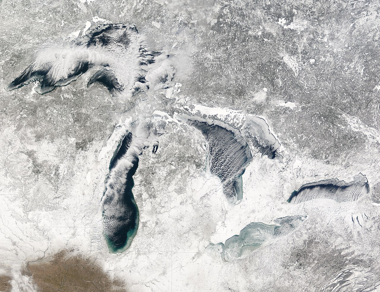
| বিবরণ | The race is on to see which will freeze first: the northeastern offshoot of Lake Huron—Georgian Bay—or Lake Erie. These images of the five Great Lakes—(left to right) Superior, Michigan, Huron, Erie, and Ontario—show ice beginning to build up around the shores of each of the lakes, with snow on the ground across virtually the entire scene. This image is made from observations by the Terra MODIS instrument on January 27, 2005. |
| তারিখ | |
| উৎস | NASA Visible Earth |
| লেখক | en:Moderate-Resolution Imaging Spectroradiometer |
| অন্যান্য সংস্করণ | http://visibleearth.nasa.gov/view_rec.php?id=8009 |
| এই ফাইলটি পাবলিক ডোমেইনে আছে কারণ এটি শুধুমাত্র নাসা কর্তৃক নির্মিত হয়েছিল। নাসার কপিরাইট নীতি হচ্ছে যে "নাসা কর্তৃক উল্লেখ না থাকলে নাসার উপাদান কপিরাইট দ্বারা সুরক্ষিত নয়"। (Template:PD-USGov, নাসার কপিরাইট নীতির পাতা অথবা জেপিএল চিত্র ব্যবহারের নীতি দেখুন।) | ||
 |
সতর্কবার্তা:
|
ফাইলের ইতিহাস
যেকোনো তারিখ/সময়ে ক্লিক করে দেখুন ফাইলটি তখন কী অবস্থায় ছিল।
| তারিখ/সময় | সংক্ষেপচিত্র | মাত্রা | ব্যবহারকারী | মন্তব্য | |
|---|---|---|---|---|---|
| বর্তমান | ২৩:০৩, ৯ ফেব্রুয়ারি ২০১০ | | ৫,২০০ × ৪,০০০ (৫.৩ মেগাবাইট) | Scewing | {{Information |Description=The race is on to see which will freeze first: the northeastern offshoot of Lake Huron—Georgian Bay—or Lake Erie. These images of the five Great Lakes—(left to right) Superior, Michigan, Huron, Erie, and Ontario—show ice |
সংযোগসমূহ
নিচের পৃষ্ঠা(গুলো) থেকে এই ছবিতে সংযোগ আছে:
ফাইলের বৈশ্বিক ব্যবহার
নিচের অন্যান্য উইকিগুলো এই ফাইলটি ব্যবহার করে:
- ar.wikipedia.org-এ ব্যবহার
- as.wikipedia.org-এ ব্যবহার
- bh.wikipedia.org-এ ব্যবহার
- et.wikipedia.org-এ ব্যবহার
- sr.wikipedia.org-এ ব্যবহার
- test2.wikipedia.org-এ ব্যবহার