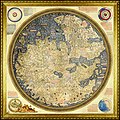
চিত্র:FraMauroDetailedMap.jpg

এই প্রাকদর্শনের আকার: ৬০০ × ৬০০ পিক্সেল। অন্যান্য আকারসমূহ: ২৪০ × ২৪০ পিক্সেল | ৪৮০ × ৪৮০ পিক্সেল | ৭৬৮ × ৭৬৮ পিক্সেল | ১,০২৪ × ১,০২৪ পিক্সেল | ২,০৪৮ × ২,০৪৮ পিক্সেল | ৫,০০০ × ৫,০০০ পিক্সেল।
পূর্ণ রেজোলিউশন (৫,০০০ × ৫,০০০ পিক্সেল, ফাইলের আকার: ১৩.২২ মেগাবাইট, এমআইএমই ধরন: image/jpeg)
ফাইলের ইতিহাস
যেকোনো তারিখ/সময়ে ক্লিক করে দেখুন ফাইলটি তখন কী অবস্থায় ছিল।
| তারিখ/সময় | সংক্ষেপচিত্র | মাত্রা | ব্যবহারকারী | মন্তব্য | |
|---|---|---|---|---|---|
| বর্তমান | ১২:৪৯, ২২ আগস্ট ২০২২ |  | ৫,০০০ × ৫,০০০ (১৩.২২ মেগাবাইট) | Mike Krüger | higher resolution |
| ১৬:৪৫, ১ সেপ্টেম্বর ২০১৭ |  | ২,২৫৫ × ২,২৪৫ (১০.৬১ মেগাবাইট) | Amphioxi | Reverted to version as of 10:02, 1 May 2007 (UTC), due to incorrect rotation. | |
| ২১:১২, ১৩ জুন ২০১৭ |  | ২,২৪৮ × ২,২৪০ (১০.৫৭ মেগাবাইট) | SteinsplitterBot | Bot: Image rotated by 180° | |
| ১০:০২, ১ মে ২০০৭ |  | ২,২৫৫ × ২,২৪৫ (১০.৬১ মেগাবাইট) | World Imaging | {{Information |Description=Fra Mauro map (1460) |Source="The Fra Mauro map" |Date=2006 |Author=Piero Falchetta }} |
সংযোগসমূহ
এই ফাইল ব্যবহার করে এমন কোনো পাতা নেই।
ফাইলের বৈশ্বিক ব্যবহার
নিচের অন্যান্য উইকিগুলো এই ফাইলটি ব্যবহার করে:
- ca.wikipedia.org-এ ব্যবহার
- de.wikipedia.org-এ ব্যবহার
- en.wikipedia.org-এ ব্যবহার
- es.wikipedia.org-এ ব্যবহার
- fa.wikipedia.org-এ ব্যবহার
- fr.wikipedia.org-এ ব্যবহার
- hr.wikipedia.org-এ ব্যবহার
- hu.wikipedia.org-এ ব্যবহার
- id.wikipedia.org-এ ব্যবহার
- nl.wikipedia.org-এ ব্যবহার
- pnb.wikipedia.org-এ ব্যবহার
- pt.wikipedia.org-এ ব্যবহার
- ru.wikipedia.org-এ ব্যবহার
- sh.wikipedia.org-এ ব্যবহার
- sv.wikipedia.org-এ ব্যবহার
- tr.wikipedia.org-এ ব্যবহার
- uk.wikipedia.org-এ ব্যবহার
- ur.wikipedia.org-এ ব্যবহার
- www.wikidata.org-এ ব্যবহার

