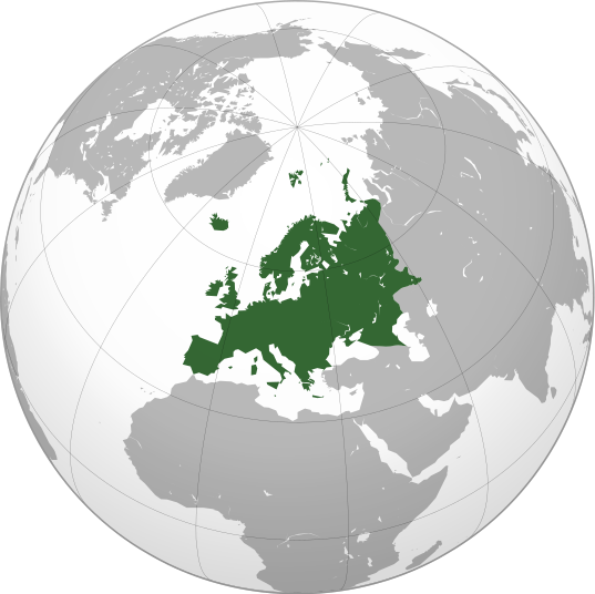
চিত্র:Europe orthographic Caucasus Urals boundary.svg

এই SVG ফাইলের জন্য এই PNG প্রাকদর্শনের আকার: ৫৩৭ × ৫৩৬ পিক্সেল। অন্যান্য আকারসমূহ: ২৪০ × ২৪০ পিক্সেল | ৪৮১ × ৪৮০ পিক্সেল | ৭৬৯ × ৭৬৮ পিক্সেল | ১,০২৬ × ১,০২৪ পিক্সেল | ২,০৫২ × ২,০৪৮ পিক্সেল।
পূর্ণ রেজোলিউশন (এসভিজি ফাইল, সাধারণত ৫৩৭ × ৫৩৬ পিক্সেল, ফাইলের আকার: ৭৭ কিলোবাইট)
ফাইলের ইতিহাস
যেকোনো তারিখ/সময়ে ক্লিক করে দেখুন ফাইলটি তখন কী অবস্থায় ছিল।
| তারিখ/সময় | সংক্ষেপচিত্র | মাত্রা | ব্যবহারকারী | মন্তব্য | |
|---|---|---|---|---|---|
| বর্তমান | ১৩:৩২, ৪ সেপ্টেম্বর ২০২২ |  | ৫৩৭ × ৫৩৬ (৭৭ কিলোবাইট) | M.Bitton | Reverted to version as of 12:03, 4 September 2022 (UTC): per COM:OVERWRITE |
| ১৩:৩০, ৪ সেপ্টেম্বর ২০২২ |  | ৫৩৭ × ৫৩৬ (১৭৭ কিলোবাইট) | Рагин1987 | Small correction | |
| ১২:০৩, ৪ সেপ্টেম্বর ২০২২ |  | ৫৩৭ × ৫৩৬ (৭৭ কিলোবাইট) | M.Bitton | Reverted to version as of 05:48, 12 March 2019 (UTC): per COM:OVERWRITE + fake svg | |
| ১৯:১২, ৩০ আগস্ট ২০২২ |  | ২,০৫২ × ২,০৪৮ (৮৭৪ কিলোবাইট) | Рагин1987 | More correct visualization of the dividing line on the territory of the Caucasus Range | |
| ০৫:৪৮, ১২ মার্চ ২০১৯ |  | ৫৩৭ × ৫৩৬ (৭৭ কিলোবাইট) | AndreyKva | Optimized. | |
| ১৯:২৫, ৩ মার্চ ২০১৬ |  | ৫৩৭ × ৫৩৬ (১৯৭ কিলোবাইট) | Denniss | Reverted to version as of 13:27, 19 October 2014 (UTC) | |
| ১৮:৩৭, ৩ মার্চ ২০১৬ |  | ৫৩৭ × ৫৩৬ (২৩৯ কিলোবাইট) | Ercwlff | UC UC UC | |
| ১৩:২৭, ১৯ অক্টোবর ২০১৪ |  | ৫৩৭ × ৫৩৬ (১৯৭ কিলোবাইট) | Deni Mataev | Again, The entirety of Georgia is not in Europe geographically, only North Eastern parts are | |
| ২০:০৫, ১৮ অক্টোবর ২০১৪ |  | ৫৩৭ × ৫৩৬ (২৩৮ কিলোবাইট) | Politologia | Reverted to version as of 10:57, 18 October 2014 In all maps Georgia is part of Georgia. There is at list 10 versions of borders of Europe in most of them Georgia is part of Europa | |
| ২০:০৪, ১৮ অক্টোবর ২০১৪ |  | ৫৩৭ × ৫৩৬ (২৩৮ কিলোবাইট) | Politologia | Reverted to version as of 10:57, 18 October 2014 In all maps Georgia is part of Georgia. |
সংযোগসমূহ
নিচের পৃষ্ঠা(গুলো) থেকে এই ছবিতে সংযোগ আছে:
- অতিমহাদেশ
- অস্ট্রেলিয়া (মহাদেশ)
- অ্যান্টার্কটিকা
- আফ্রিকা
- আফ্রো-ইউরেশিয়া
- ইউনিয়ন জ্যাক
- ইউরেশিয়া
- ইউরোপ
- ইউরোপের সার্বভৌম রাষ্ট্র এবং নির্ভরশীল অঞ্চলসমূহের তালিকা
- উত্তর আমেরিকা
- উত্তরাঞ্চলীয় আমেরিকা
- এশিয়া
- এশিয়ার সার্বভৌম রাষ্ট্র ও নির্ভরশীল অঞ্চলসমূহের তালিকা
- ওশেনিয়া
- কসোভোর পতাকা
- কেরোগলেন মালভূমি
- গন্ডোয়ানা
- টেরা অস্ট্রালিস
- দক্ষিণ আমেরিকা
- নয়াবিশ্ব
- নিমজ্জিত মহাদেশ
- প্যানজিয়া
- বিভ্রমমূলক দ্বীপ
- ভালবারা
- মহাদেশ
- মহাদেশ অনুযায়ী সার্বভৌম রাষ্ট্র এবং নির্ভরশীল অঞ্চলসমূহের তালিকা
- মালদ্বীপের বৈদেশিক সম্পর্ক
- লরেশিয়া
- সাহুল (মহাদেশ)
- সুন্দা (মহাদেশ)
- টেমপ্লেট:About continent and region topic templates
- টেমপ্লেট:ইউরোপের পতাকা
- টেমপ্লেট:দক্ষিণ আমেরিকা বিষয়/নথি
- টেমপ্লেট:পৃথিবীর মহাদেশসমূহ
- বিষয়শ্রেণী:মহাদেশ অনুযায়ী বিষয়শ্রেণী
- প্রবেশদ্বার:ভূবিজ্ঞান
ফাইলের বৈশ্বিক ব্যবহার
নিচের অন্যান্য উইকিগুলো এই ফাইলটি ব্যবহার করে:
- ab.wikipedia.org-এ ব্যবহার
- ace.wikipedia.org-এ ব্যবহার
- ady.wikipedia.org-এ ব্যবহার
- af.wikipedia.org-এ ব্যবহার
- ar.wikipedia.org-এ ব্যবহার
- بوابة:آسيا
- بوابة:أوروبا
- بوابة:إفريقيا
- بوابة:القارة القطبية الجنوبية
- بوابة:القارة القطبية الجنوبية/بوابات شقيقة
- قائمة جوازات السفر
- بوابة:تركيا
- بوابة:تركيا/بوابات شقيقة
- بوابة:جغرافيا/مقالة مختارة/أرشيف
- المرأة في تركيا
- بوابة:أوروبا/واجهة
- بوابة:تصفح
- بوابة:تصفح/جغرافيا
- قائمة مفاتيح الاتصال الدولية
- المرأة في ألمانيا
- بوابة:إسطنبول
- بوابة:آسيا/بوابات شقيقة
- ويكيبيديا:مقالة الصفحة الرئيسية المختارة/398
- بوابة:جغرافيا/مقالة مختارة/21
- معاملة المثليين في أوروبا
- المرأة في أوروبا
- المرأة في البرتغال
- المرأة في فنلندا
- المرأة في مقدونيا الشمالية
- المرأة في ترانسنيستريا
- المرأة في الفاتيكان
- المرأة في أذربيجان
- المرأة في اليونان
- المرأة في ألبانيا
- المرأة في إيطاليا
- المرأة في الجبل الأسود
এই ফাইলের অন্যান্য বৈশ্বিক ব্যবহার দেখুন।

