চিত্র:Carte Lewis and Clark Expedition.png
এই প্রাকদর্শনের আকার: ৮০০ × ৫২০ পিক্সেল। অন্যান্য আকারসমূহ: ৩২০ × ২০৮ পিক্সেল | ৬৪০ × ৪১৬ পিক্সেল | ১,০২৪ × ৬৬৫ পিক্সেল | ১,৫১৩ × ৯৮৩ পিক্সেল।
পূর্ণ রেজোলিউশন (১,৫১৩ × ৯৮৩ পিক্সেল, ফাইলের আকার: ৮৪ কিলোবাইট, এমআইএমই ধরন: image/png)
| এই ফাইলটি উইকিমিডিয়া কমন্স থেকে নেওয়া। সেখানের বর্ণনা পাতার বিস্তারিত নিম্নে দেখানো হলো। (সম্পাদনা)
|

|
This historical map image could be re-created using vector graphics as an SVG file. This has several advantages; see Commons:Media for cleanup for more information. If an SVG form of this image is available, please upload it and afterwards replace this template with
{{vector version available|new image name}}.
It is recommended to name the SVG file “Carte Lewis and Clark Expedition.svg”—then the template Vector version available (or Vva) does not need the new image name parameter. |
সারাংশ
| বিবরণ |
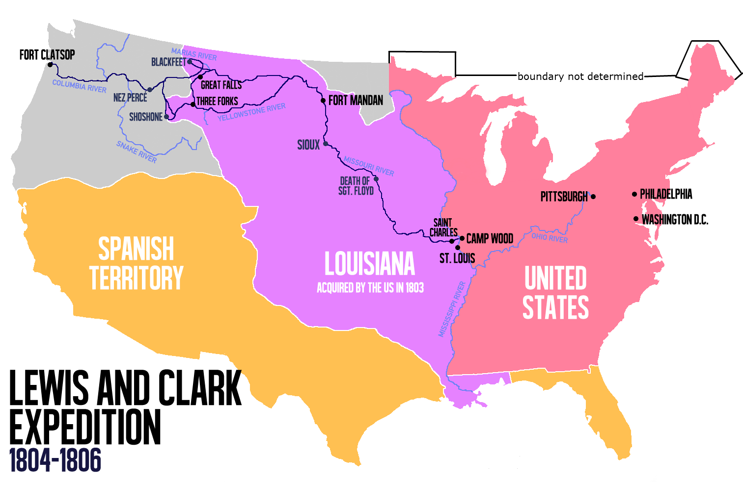
English: Route of the Lewis and Clark Expedition |
| তারিখ | |
| উৎস |
নিজের কাজ, এই ফাইলটি যেখান থেকে নেওয়া হয়েছে: Carte Lewis-Clark Expedition-en.png |
| লেখক | Victor van Werkhooven |
| অন্যান্য সংস্করণ |
 |
লাইসেন্স প্রদান
| আমি, এই কাজের স্বত্বাধিকারী, এতদ্দ্বারা আমি এই কাজকে পাবলিক ডোমেইন লাইসেন্সের আওতায় প্রকাশ করলাম। এটি বিশ্বব্যাপী প্রযোজ্য হবে। কিছু দেশে এটি আইনত সিদ্ধ নাও হতে পারে, যদি তাই হয়: আমি যে-কাউকে এই কাজটি যেকোনো উদ্দেশ্যে, বিনাশর্তে ব্যবহারের অনুমতি প্রদান করছি, যদি না সেই শর্তগুলো আইনত প্রয়োজনীয় হয়। |
ফাইলের ইতিহাস
যেকোনো তারিখ/সময়ে ক্লিক করে দেখুন ফাইলটি তখন কী অবস্থায় ছিল।
| তারিখ/সময় | সংক্ষেপচিত্র | মাত্রা | ব্যবহারকারী | মন্তব্য | |
|---|---|---|---|---|---|
| বর্তমান | ১৪:২১, ১৩ জুন ২০১৪ | | ১,৫১৩ × ৯৮৩ (৮৪ কিলোবাইট) | Nwbeeson | Reverted to version as of 14:18, 13 June 2014 |
| ১৪:২০, ১৩ জুন ২০১৪ |  | ১,৫১৩ × ৯৮৩ (৮৪ কিলোবাইট) | Nwbeeson | Corrected boundary of the United States. The original left out Maine, Michigan, Wisconsin, and part of Minnesota, none of which were states, but all of which were definitely part of the territory of the United States. | |
| ১৪:১৮, ১৩ জুন ২০১৪ |  | ১,৫১৩ × ৯৮৩ (৮৪ কিলোবাইট) | Nwbeeson | Corrected boundary of the United States. The original left out Maine, Michigan, Wisconsin, and part of Minnesota, none of which were states, but all of which were definitely part of the territory of the United States. | |
| ১৫:১৭, ২২ মে ২০১৪ |  | ১,৫১৩ × ৯৮৩ (১৩৪ কিলোবাইট) | Luctor | User created page with UploadWizard |
সংযোগসমূহ
নিচের পৃষ্ঠা(গুলো) থেকে এই ছবিতে সংযোগ আছে:
ফাইলের বৈশ্বিক ব্যবহার
নিচের অন্যান্য উইকিগুলো এই ফাইলটি ব্যবহার করে:
- ast.wikipedia.org-এ ব্যবহার
- de.wikipedia.org-এ ব্যবহার
- en.wikipedia.org-এ ব্যবহার
- es.wikipedia.org-এ ব্যবহার
- et.wikipedia.org-এ ব্যবহার
- eu.wikipedia.org-এ ব্যবহার
- fa.wikipedia.org-এ ব্যবহার
- gl.wikipedia.org-এ ব্যবহার
- hu.wikipedia.org-এ ব্যবহার
- it.wikipedia.org-এ ব্যবহার
- ko.wikipedia.org-এ ব্যবহার
- ms.wikipedia.org-এ ব্যবহার
- nl.wikipedia.org-এ ব্যবহার
- no.wikipedia.org-এ ব্যবহার
- oc.wikipedia.org-এ ব্যবহার
- pl.wikipedia.org-এ ব্যবহার
- sr.wikipedia.org-এ ব্যবহার
- tr.wikipedia.org-এ ব্যবহার
- www.wikidata.org-এ ব্যবহার
- zh.wikipedia.org-এ ব্যবহার