চিত্র:Asia Europe transcontinental.png

এই প্রাকদর্শনের আকার: ৭৬৩ × ৫৯৯ পিক্সেল। অন্যান্য আকারসমূহ: ৩০৬ × ২৪০ পিক্সেল | ৬১১ × ৪৮০ পিক্সেল | ৯৭৮ × ৭৬৮ পিক্সেল | ১,২৬৮ × ৯৯৬ পিক্সেল।
পূর্ণ রেজোলিউশন (১,২৬৮ × ৯৯৬ পিক্সেল, ফাইলের আকার: ৪৬ কিলোবাইট, এমআইএমই ধরন: image/png)
| এই ফাইলটি উইকিমিডিয়া কমন্স থেকে নেওয়া। সেখানের বর্ণনা পাতার বিস্তারিত নিম্নে দেখানো হলো। (সম্পাদনা)
|
| বিবরণ |
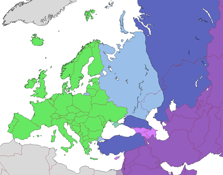
English: Map of Europe, indicating continental boundary (by Britannica and Great Soviet Encyclopedia) and transcontinental states.
States geographically in Europe (excepting overseas possessions)
Transcontinental states, European territory
Transcontinental states, Asian territory
Asian countries, sometimes referred to as Europe according to political, economic, and historical and cultural criteria (Azerbaijan, Armenia, Georgia, Cyprus)
Geographically Asian states (island states of Cyprus and Bahrain usually grouped with Asia geographically)
Asian part of Egypt Русский: Карта Европы с указанием границ частей света (по БСЭ и Британнике) и трансконтинентальных государств.
Государства, расположенные в Европе (за исключением заморских владений)
Трансконтинентальные государства, европейская территория
Трансконтинентальные государства, азиатская территория
Государства Азии, иногда относимые к Европе по политическим, экономическим, и историко-культурным критериям
Государства, расположенные в Азии
Азиатская часть Египта |
| তারিখ | |
| উৎস | |
| লেখক |
.png)
লাইসেন্স প্রদান
এই ফাইলটি ক্রিয়েটিভ কমন্স অ্যাট্রিবিউশন-শেয়ার অ্যালাইক ৩.০ আনপোর্টেড লাইসেন্সের আওতায় লাইসেন্সকৃত।
- আপনি স্বাধীনভাবে:
- বণ্টন করতে পারেন – এ কাজটি অনুলিপি, বিতরণ এবং প্রেরণ করতে পারেন
- পুনঃমিশ্রণ করতে পারেন – কাজটি অভিযোজন করতে পারেন
- নিম্নের শর্তাবলীর ভিত্তিতে:
- স্বীকৃতিপ্রদান – আপনাকে অবশ্যই যথাযথ স্বীকৃতি প্রদান করতে হবে, লাইসেন্সের একটি লিঙ্ক সরবরাহ করতে হবে এবং কোনো পরিবর্তন হয়েছে কিনা তা নির্দেশ করতে হবে। আপনি যেকোনো যুক্তিসঙ্গত পদ্ধতিতে এটি করতে পারেন। কিন্তু এমন ভাবে নয়, যাতে প্রকাশ পায় যে লাইসেন্সধারী আপনাকে বা আপনার এই ব্যবহারের জন্য অনুমোদন দিয়েছে।
- একইভাবে বণ্টন – আপনি যদি কাজটি পুনঃমিশ্রণ, রুপান্তর, বা এর ওপর ভিত্তি করে নতুন সৃষ্টিকর্ম তৈরি করেন, তবে আপনাকে অবশ্যই আপনার অবদান একই লাইসেন্স বা একই রকমের লাইসেন্সের আওতায় বিতরণ করতে হবে।
| Annotations | This image is annotated: View the annotations at Commons |
ফাইলের ইতিহাস
যেকোনো তারিখ/সময়ে ক্লিক করে দেখুন ফাইলটি তখন কী অবস্থায় ছিল।
| তারিখ/সময় | সংক্ষেপচিত্র | মাত্রা | ব্যবহারকারী | মন্তব্য | |
|---|---|---|---|---|---|
| বর্তমান | ১০:২৩, ১৪ নভেম্বর ২০২২ | | ১,২৬৮ × ৯৯৬ (৪৬ কিলোবাইট) | Рагин1987 | Highlighted with a light purple hue the countries of Asia, sometimes attributed to Europe according to political, economic, and historical and cultural criteria (Transcaucasia, Cyprus). |
| ১২:০২, ২৯ আগস্ট ২০২২ |  | ১,২৬৮ × ৯৯৬ (৪৬ কিলোবাইট) | Рагин1987 | Small correction | |
| ০৭:০৩, ১৮ ফেব্রুয়ারি ২০২০ |  | ১,২৬৮ × ৯৯৬ (৫৬ কিলোবাইট) | Insider | fix: mixed color. not dark blue | |
| ০৬:৫৫, ১৮ ফেব্রুয়ারি ২০২০ |  | ১,২৬৮ × ৯৯৬ (৬০ কিলোবাইট) | Insider | Reverted to version as of 07:01, 13 October 2014 (UTC) Crimea that is Europe | |
| ০৯:০৪, ১০ ফেব্রুয়ারি ২০২০ |  | ১,২৬৮ × ৯৯৬ (৮৪ কিলোবাইট) | Compu wiki | Крым — это Россия. Crimea is Russia. | |
| ০৭:০১, ১৩ অক্টোবর ২০১৪ |  | ১,২৬৮ × ৯৯৬ (৬০ কিলোবাইট) | Insider | Reverted to version as of 10:10, 1 July 2014 Crimea that is Europe | |
| ১২:৩১, ১১ অক্টোবর ২০১৪ |  | ১,২৬৮ × ৯৯৬ (৮৪ কিলোবাইট) | Michael1238 | Crimea | |
| ১০:১০, ১ জুলাই ২০১৪ |  | ১,২৬৮ × ৯৯৬ (৬০ কিলোবাইট) | Insider | {{Information |Description={{en|1= Map of Europe, indicating continental boundary and transcontinental states. {{legend|#67e836|States geographically in Europe (excepting overseas possessions; island states UK, Ireland, Iceland and Malta usually group... |
সংযোগসমূহ
এই ফাইল ব্যবহার করে এমন কোনো পাতা নেই।
ফাইলের বৈশ্বিক ব্যবহার
নিচের অন্যান্য উইকিগুলো এই ফাইলটি ব্যবহার করে:
- hy.wikipedia.org-এ ব্যবহার
- kk.wikipedia.org-এ ব্যবহার
- ru.wikipedia.org-এ ব্যবহার