চিত্র:Africa independence dates.PNG

এই প্রাকদর্শনের আকার: ৫৬৪ × ৬০০ পিক্সেল। অন্যান্য আকারসমূহ: ২২৬ × ২৪০ পিক্সেল | ৪৫১ × ৪৮০ পিক্সেল | ৭৫২ × ৮০০ পিক্সেল।
পূর্ণ রেজোলিউশন (৭৫২ × ৮০০ পিক্সেল, ফাইলের আকার: ৪২ কিলোবাইট, এমআইএমই ধরন: image/png)
| এই ফাইলটি উইকিমিডিয়া কমন্স থেকে নেওয়া। সেখানের বর্ণনা পাতার বিস্তারিত নিম্নে দেখানো হলো। (সম্পাদনা)
|

|
File:Africa independence dates.svg এই ফাইলের একটি ভেক্টর সংস্করণ। যখন উচ্চতর তখন এটি এই রাস্টার চিত্রের জায়গায় ব্যবহার করা উচিত।
File:Africa independence dates.PNG → File:Africa independence dates.svg
ভেক্টর গ্রাফিক্স সম্পর্কে আরও তথ্যের জন্য, কমন্স এসভিজিতে রূপান্তর সম্পর্কে পড়ুন। সেখানে মিডিয়াউইকির এসভিজি চিত্র সমর্থন সম্পর্কে তথ্য রয়েছে। |
 |
সারাংশ
Español: Fechas de independencia de los países africanos.
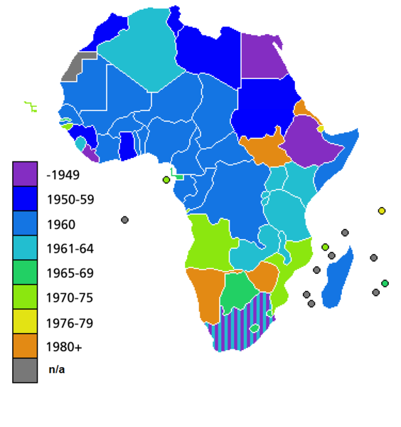
Countries of Africa, with date of independence
লাইসেন্স প্রদান

|
এই নথি অনুলিপি, বিতরণ এবং/বা পরিবর্তন করার অনুমতি ফ্রি সফটওয়্যার ফাউন্ডেশন কর্তৃক প্রকাশিত গনু ফ্রি ডকুমেন্টেশন লাইসেন্স, সংস্করণ ১.২ বা তার পরবর্তী সংস্করণের আওতায় অনুমতিপ্রাপ্ত; যে কোনো রকম অনুচ্ছেদ পরিবর্তন, সম্মুখ-প্রচ্ছদের লেখা, পিছন-প্রচ্ছদের লেখা পরিবর্তন করা ছাড়াই। এই লাইসেন্সের একটি অনুলিপি গনু ফ্রি ডকুমেন্টেশন লাইসেন্স শিরোনামের অনুচ্ছেদে অন্তর্ভুক্ত করা আছে। |
| এই ফাইলটি ক্রিয়েটিভ কমন্স অ্যাট্রিবিউশন-শেয়ার অ্যালাইক ৩.০ আনপোর্টেড লাইসেন্সের আওতায় লাইসেন্সকৃত। | ||
| ||
| এই লাইসেন্স ট্যাগটি জিএফডিএল লাইসেন্স হালনাগাদের অংশ হিসেবে এই ফাইলে সংযুক্ত হয়েছে। |
ফাইলের ইতিহাস
যেকোনো তারিখ/সময়ে ক্লিক করে দেখুন ফাইলটি তখন কী অবস্থায় ছিল।
| তারিখ/সময় | সংক্ষেপচিত্র | মাত্রা | ব্যবহারকারী | মন্তব্য | |
|---|---|---|---|---|---|
| বর্তমান | ০৪:২৫, ৯ জুলাই ২০১১ | | ৭৫২ × ৮০০ (৪২ কিলোবাইট) | Hoshie | added South Sudan to the map |
| ০২:৩৪, ১৯ জুন ২০১১ |  | ৭৫২ × ৮০০ (৪২ কিলোবাইট) | Muso | Reverted to version as of 10:09, 22 April 2011 | |
| ০২:১৯, ১৯ জুন ২০১১ |  | ৭৫২ × ৮০০ (১৪ কিলোবাইট) | Muso | Zimbabwe got his independence in 1965, therefore correct its color from orange green | |
| ১০:০৯, ২২ এপ্রিল ২০১১ |  | ৭৫২ × ৮০০ (৪২ কিলোবাইট) | Hoshie | added the French departements of Mayotte and Reunion and the Ilies Eparses distict of the TAAF; CIA maps was used as a source. A version w/ Southern Sudan is ready for July. | |
| ০৩:০০, ১১ এপ্রিল ২০১১ |  | ৭৫২ × ৮০০ (৪২ কিলোবাইট) | Hoshie | added Cabinda (Angola) to the map; a version with Southern Sudan is ready once they declare independence in July. | |
| ১৮:১৬, ৬ এপ্রিল ২০১০ |  | ৭৫২ × ৮০০ (৩৮ কিলোবাইট) | Lemonade100 | De Jure Independance of Zimbawe and South Africa (changed from de facto), St Helena and dependancies added. | |
| ০১:৩৫, ২৩ মার্চ ২০০৮ |  | ৭৫২ × ৬৯০ (৩৬ কিলোবাইট) | Serg!o | UN considers Sahara as a colony - ONU considera Sahara como colonia | |
| ১১:৪৪, ২২ মার্চ ২০০৬ |  | ৭৫২ × ৬৯০ (৩৬ কিলোবাইট) | Roke~commonswiki | Countries of Africa, with date of independence Category: Maps of Africa Category: History of Africa |
সংযোগসমূহ
নিচের পৃষ্ঠা(গুলো) থেকে এই ছবিতে সংযোগ আছে:
ফাইলের বৈশ্বিক ব্যবহার
নিচের অন্যান্য উইকিগুলো এই ফাইলটি ব্যবহার করে:
- el.wikivoyage.org-এ ব্যবহার
- en.wikipedia.org-এ ব্যবহার
- hi.wikipedia.org-এ ব্যবহার