চিত্র:1873 Stieler Map of Asia Minor, Syria and Israel - Palestine (modern Turkey) - Geographicus - Klein-AsienSyrien-stieler-1873.jpg

এই প্রাকদর্শনের আকার: ৭৩৩ × ৫৯৯ পিক্সেল। অন্যান্য আকারসমূহ: ২৯৪ × ২৪০ পিক্সেল | ৫৮৭ × ৪৮০ পিক্সেল | ৯৪০ × ৭৬৮ পিক্সেল | ১,২৫৩ × ১,০২৪ পিক্সেল | ২,৫০৫ × ২,০৪৮ পিক্সেল | ৪,০০০ × ৩,২৭০ পিক্সেল।
পূর্ণ রেজোলিউশন (৪,০০০ × ৩,২৭০ পিক্সেল, ফাইলের আকার: ৩.৭৯ মেগাবাইট, এমআইএমই ধরন: image/jpeg)
| এই ফাইলটি উইকিমিডিয়া কমন্স থেকে নেওয়া। সেখানের বর্ণনা পাতার বিস্তারিত নিম্নে দেখানো হলো। (সম্পাদনা)
|
| Justus Perthes: Klein-Asien & Syrien nebst Den Westlichen Theilen von Armenien, Kurdistan & Mesopotamien.
( |
|||||||||||||||||||||||||||
|---|---|---|---|---|---|---|---|---|---|---|---|---|---|---|---|---|---|---|---|---|---|---|---|---|---|---|---|
| শিল্পী |
|
||||||||||||||||||||||||||
| শিরোনাম |
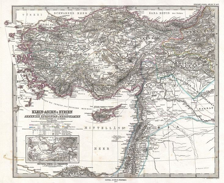
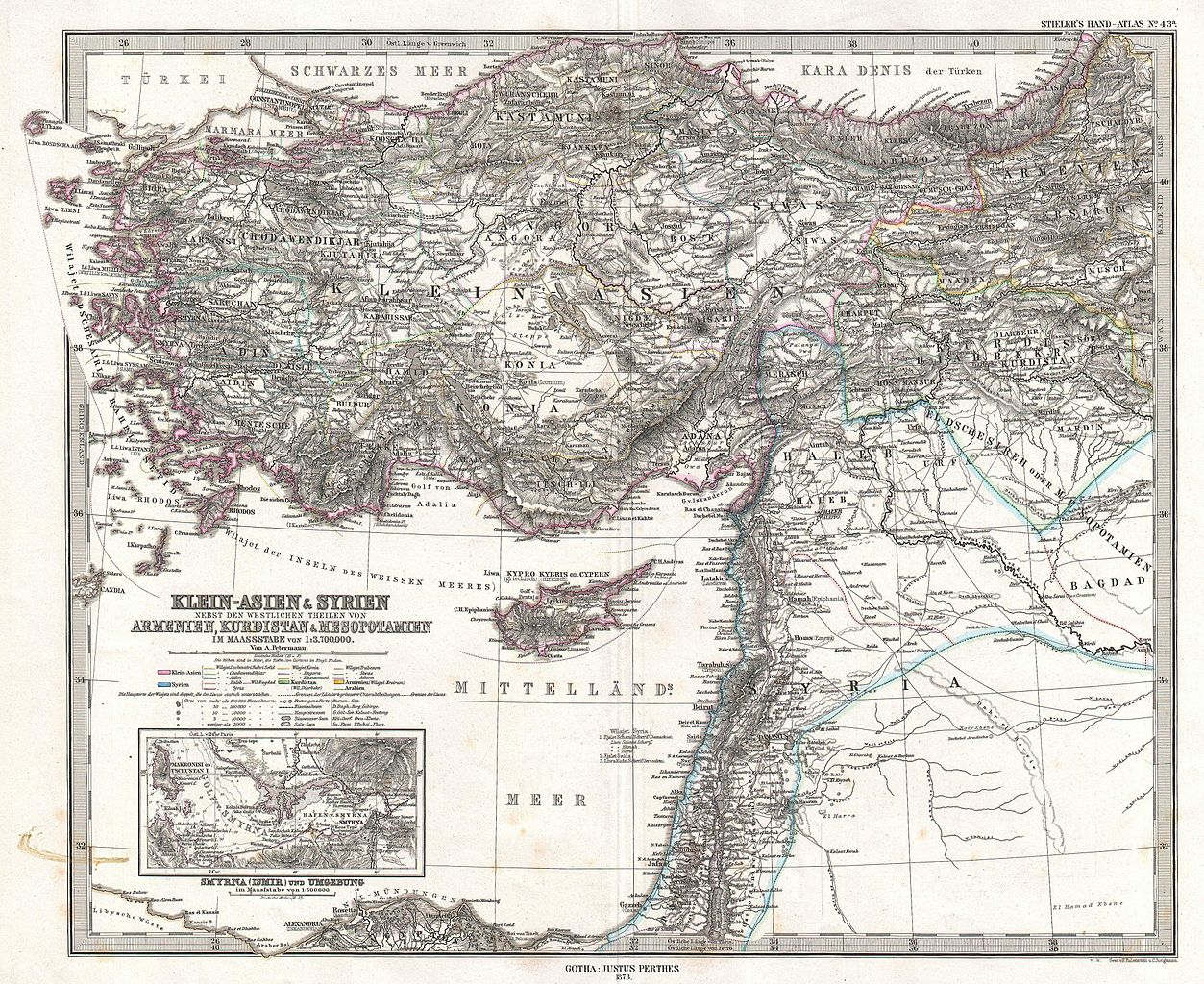
Klein-Asien & Syrien nebst Den Westlichen Theilen von Armenien, Kurdistan & Mesopotamien. |
||||||||||||||||||||||||||
| বিবরণ |
English: This is a beautiful example of Stieler’s 1873 map of the modern day Turkey, Syria, Israel / Palestine and Cyprus. Highly detailed with both political and physical data. Shows cities, mountains, roads, rivers and local divisions. An inset in the lower left quadrant features the vicinity of Smyrna (modern Ismir), including depth sounding in the Gulf of Smyrna and harbor. Printed to a high production standard, as was typical of German and especially Perthes/Stieler maps of this period. Published by the Justus Perthes firm and engraved by F. Eulenstein and C. Jungmann for issue as plate no. 43 in the 1873 edition of Stieler’s Hand-Atlas . |
||||||||||||||||||||||||||
| তারিখ | ১৮৭৩ (dated) | ||||||||||||||||||||||||||
| আকার | উচ্চতা: ১৩.৫ ইঞ্চি (৩৪.২ সে.মি.); প্রস্থ: ১৬.৬ ইঞ্চি (৪২.১ সে.মি.) | ||||||||||||||||||||||||||
| সংযোজন সংখ্যা |
Geographicus link: Klein-AsienSyrien-stieler-1873 |
||||||||||||||||||||||||||
| উৎস/আলোকচিত্রগ্রাহক |
Stieler's Hand-Atlas (1873 issue).
|
||||||||||||||||||||||||||
| অনুমতি (এ ফাইলের পুনঃব্যবহার) |
|
||||||||||||||||||||||||||

_-_Geographicus_-_Klein-AsienSyrien-stieler-1873.jpg?uselang=bn)
_-_Geographicus_-_Klein-AsienSyrien-stieler-1873.jpg&action=edit)
ফাইলের ইতিহাস
যেকোনো তারিখ/সময়ে ক্লিক করে দেখুন ফাইলটি তখন কী অবস্থায় ছিল।
| তারিখ/সময় | সংক্ষেপচিত্র | মাত্রা | ব্যবহারকারী | মন্তব্য | |
|---|---|---|---|---|---|
| বর্তমান | ০৮:০২, ১৮ মার্চ ২০১১ | | ৪,০০০ × ৩,২৭০ (৩.৭৯ মেগাবাইট) | BotMultichill | {{subst:User:Multichill/Geographicus |link=http://www.geographicus.com/P/AntiqueMap/Klein-AsienSyrien-stieler-1873 |product_name=1873 Stieler Map of Asia Minor, Syria and Israel - Palestine (modern Turkey) |map_title=Klein-Asien & Syrien nebst Den Westlic |
সংযোগসমূহ
নিচের পৃষ্ঠা(গুলো) থেকে এই ছবিতে সংযোগ আছে:
ফাইলের বৈশ্বিক ব্যবহার
নিচের অন্যান্য উইকিগুলো এই ফাইলটি ব্যবহার করে:
- ar.wikipedia.org-এ ব্যবহার
- az.wikipedia.org-এ ব্যবহার
- en.wikipedia.org-এ ব্যবহার
- eo.wikipedia.org-এ ব্যবহার
- it.wikipedia.org-এ ব্যবহার
- ko.wikipedia.org-এ ব্যবহার
- mk.wikipedia.org-এ ব্যবহার
- mt.wikipedia.org-এ ব্যবহার
- pnb.wikipedia.org-এ ব্যবহার
- sl.wikipedia.org-এ ব্যবহার
- tr.wikipedia.org-এ ব্যবহার
- ur.wikipedia.org-এ ব্যবহার
_-_Geographicus_-_Klein-AsienSyrien-stieler-1873.jpg)