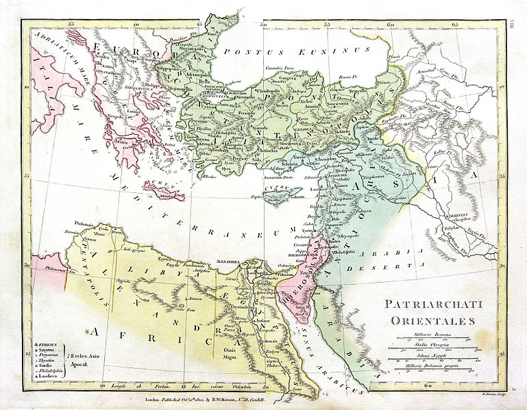
চিত্র:1800 Wilkinson Map of the 4 Eastern Churches rectified.jpg

এই প্রাকদর্শনের আকার: ৭৬৯ × ৫৯৯ পিক্সেল। অন্যান্য আকারসমূহ: ৩০৮ × ২৪০ পিক্সেল | ৬১৬ × ৪৮০ পিক্সেল | ৯৮৫ × ৭৬৮ পিক্সেল | ১,২৮০ × ৯৯৮ পিক্সেল | ১,৬৭৮ × ১,৩০৮ পিক্সেল।
পূর্ণ রেজোলিউশন (১,৬৭৮ × ১,৩০৮ পিক্সেল, ফাইলের আকার: ৮৯৫ কিলোবাইট, এমআইএমই ধরন: image/jpeg)
ফাইলের ইতিহাস
যেকোনো তারিখ/সময়ে ক্লিক করে দেখুন ফাইলটি তখন কী অবস্থায় ছিল।
| তারিখ/সময় | সংক্ষেপচিত্র | মাত্রা | ব্যবহারকারী | মন্তব্য | |
|---|---|---|---|---|---|
| বর্তমান | ২০:৪৭, ১০ ফেব্রুয়ারি ২০১৬ |  | ১,৬৭৮ × ১,৩০৮ (৮৯৫ কিলোবাইট) | Чръный человек | обработка |
| ১৮:০৪, ৯ ফেব্রুয়ারি ২০১৬ |  | ১,৬৭৮ × ১,৩০৮ (১.২২ মেগাবাইট) | Чръный человек | Осветление | |
| ২০:২৯, ১ মে ২০১১ |  | ১,৬৭৮ × ১,৩০৮ (১.৯১ মেগাবাইট) | MichaelBueker | color touchup | |
| ২০:১৪, ১ মে ২০১১ |  | ১,৬৭৮ × ১,৩০৮ (১.৬১ মেগাবাইট) | MichaelBueker | {{Information |Description={{en|Map of the 4 Eastern Churches in the Pentarchy, circa 500CE}} |Source=*File:1800_Wilkinson_Map_of_the_4_Eastern_Churches.jpg |Date=2011-05-01 20:13 (UTC) |Author=*[[:File:1800_Wilkinson_Map_of_the_4_Eastern_Churches.j |
সংযোগসমূহ
নিচের পৃষ্ঠা(গুলো) থেকে এই ছবিতে সংযোগ আছে:
ফাইলের বৈশ্বিক ব্যবহার
নিচের অন্যান্য উইকিগুলো এই ফাইলটি ব্যবহার করে:
- ar.wikipedia.org-এ ব্যবহার
- arz.wikipedia.org-এ ব্যবহার
- az.wikipedia.org-এ ব্যবহার
- bg.wikipedia.org-এ ব্যবহার
- ckb.wikipedia.org-এ ব্যবহার
- cs.wikipedia.org-এ ব্যবহার
- el.wikipedia.org-এ ব্যবহার
- en.wikipedia.org-এ ব্যবহার
- eo.wikipedia.org-এ ব্যবহার
- es.wikipedia.org-এ ব্যবহার
- fa.wikipedia.org-এ ব্যবহার
- fr.wikipedia.org-এ ব্যবহার
- hu.wikipedia.org-এ ব্যবহার
- id.wikipedia.org-এ ব্যবহার
- it.wikipedia.org-এ ব্যবহার
- ko.wikipedia.org-এ ব্যবহার
- mk.wikipedia.org-এ ব্যবহার
- ml.wikipedia.org-এ ব্যবহার
- pt.wikipedia.org-এ ব্যবহার
- ru.wikipedia.org-এ ব্যবহার
- sk.wikipedia.org-এ ব্যবহার
- sr.wikipedia.org-এ ব্যবহার
- sv.wikipedia.org-এ ব্যবহার
- tr.wikipedia.org-এ ব্যবহার
- uk.wikipedia.org-এ ব্যবহার
- zh-min-nan.wikipedia.org-এ ব্যবহার
এই ফাইলের অন্যান্য বৈশ্বিক ব্যবহার দেখুন।