চিত্র:Proposed states and territories of India.png
এই প্রাকদর্শনের আকার: ৫৬৯ × ৬০০ পিক্সেল। অন্যান্য আকারসমূহ: ২২৮ × ২৪০ পিক্সেল | ৪৫৫ × ৪৮০ পিক্সেল | ৭২৮ × ৭৬৮ পিক্সেল | ৯৭১ × ১,০২৪ পিক্সেল | ১,৪৫৬ × ১,৫৩৫ পিক্সেল।
পূর্ণ রেজোলিউশন (১,৪৫৬ × ১,৫৩৫ পিক্সেল, ফাইলের আকার: ৩৩২ কিলোবাইট, এমআইএমই ধরন: image/png)
| এই ফাইলটি উইকিমিডিয়া কমন্স থেকে নেওয়া। সেখানের বর্ণনা পাতার বিস্তারিত নিম্নে দেখানো হলো। (সম্পাদনা)
|

|
File:Proposed states and union territories of India.svg এই ফাইলের একটি ভেক্টর সংস্করণ। যখন উচ্চতর তখন এটি এই রাস্টার চিত্রের জায়গায় ব্যবহার করা উচিত।
File:Proposed states and territories of India.png → File:Proposed states and union territories of India.svg
ভেক্টর গ্রাফিক্স সম্পর্কে আরও তথ্যের জন্য, কমন্স এসভিজিতে রূপান্তর সম্পর্কে পড়ুন। সেখানে মিডিয়াউইকির এসভিজি চিত্র সমর্থন সম্পর্কে তথ্য রয়েছে। |
 |
| বিবরণ |
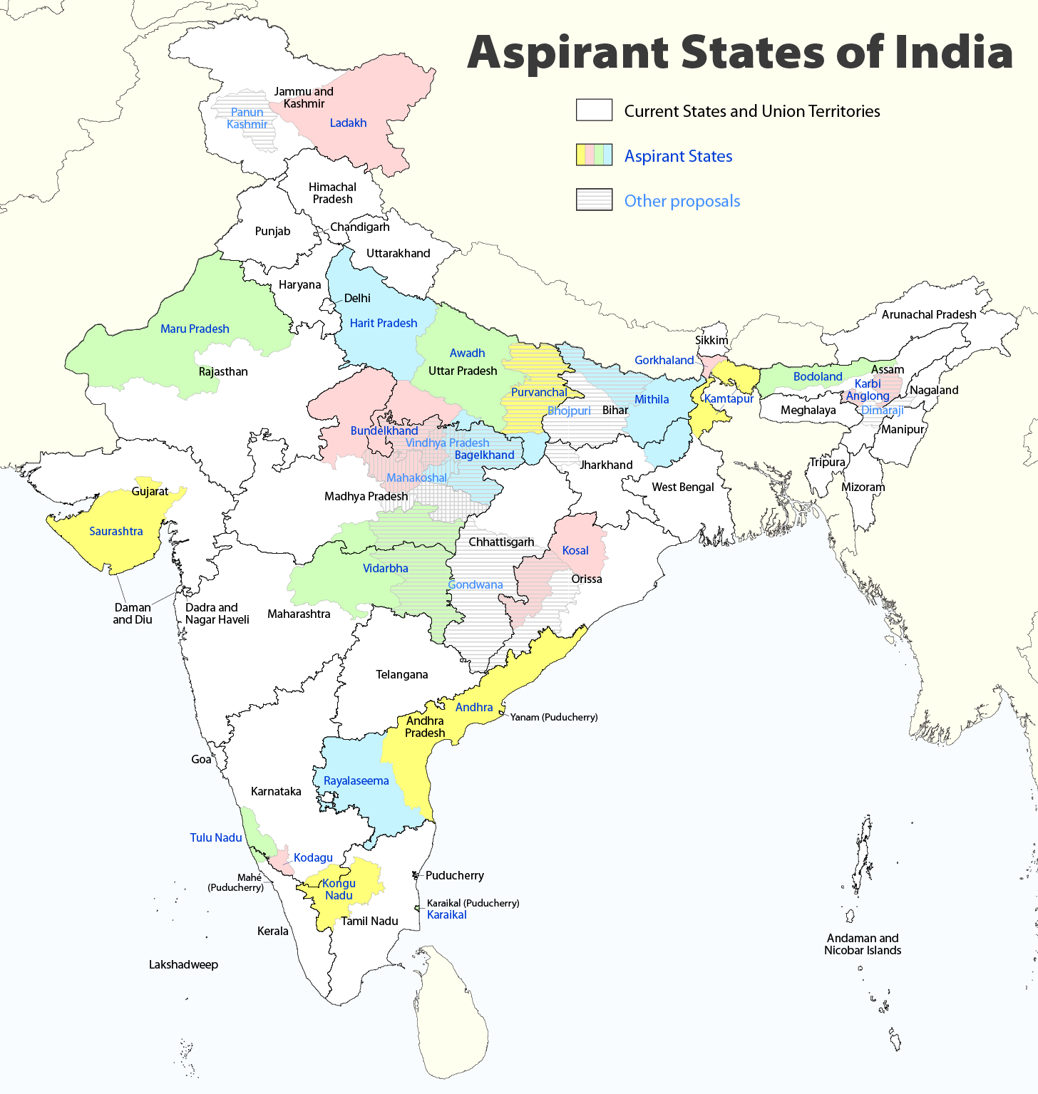
Deutsch: Indiens Anwärterstaaten
English: Aspirant States of India |
| তারিখ | |
| উৎস | নিজের কাজ |
| লেখক | Maximilian Dörrbecker (Chumwa) |
| অনুমতি (এ ফাইলের পুনঃব্যবহার) |
আমি, এই কাজের স্বত্বাধিকারী, এতদ্দ্বারা আমি এই কাজকে নিম্ন বর্ণিত লাইসেন্সের আওতায় প্রকাশ করলাম: এই ফাইলটি ক্রিয়েটিভ কমন্স অ্যাট্রিবিউশন-শেয়ার অ্যালাইক ২.৫ জেনেরিক লাইসেন্সের আওতায় লাইসেন্সকৃত।
Sie dürfen das Bild zu den folgenden Bedingungen nutzen:
|
| অন্যান্য সংস্করণ |
|

ফাইলের ইতিহাস
যেকোনো তারিখ/সময়ে ক্লিক করে দেখুন ফাইলটি তখন কী অবস্থায় ছিল।
| তারিখ/সময় | সংক্ষেপচিত্র | মাত্রা | ব্যবহারকারী | মন্তব্য | |
|---|---|---|---|---|---|
| বর্তমান | ০৯:০৬, ২ আগস্ট ২০২০ | | ১,৪৫৬ × ১,৫৩৫ (৩৩২ কিলোবাইট) | Chumwa | Reverted to version as of 21:03, 29 August 2018 (UTC) |
| ২০:০৩, ৩০ জুলাই ২০২০ |  | ১,৪৫৬ × ১,৫৩৫ (৩১৬ কিলোবাইট) | UT'sIndia | Reverted to version as of 15:15, 17 May 2013 (UTC) | |
| ২১:০৩, ২৯ আগস্ট ২০১৮ |  | ১,৪৫৬ × ১,৫৩৫ (৩৩২ কিলোবাইট) | Chumwa | extended Tulu Nadu into Kerala | |
| ২১:৫২, ৫ জুন ২০১৪ |  | ১,৪৫৬ × ১,৫৩৫ (৩৩২ কিলোবাইট) | Chumwa | borders of Rayalseema corrected | |
| ১৮:২৩, ৩ জুন ২০১৪ |  | ১,৪৫৬ × ১,৫৩৫ (৩৩২ কিলোবাইট) | Chumwa | borders of Mithila corrected | |
| ১৭:৫৩, ৩ জুন ২০১৪ |  | ১,৪৫৬ × ১,৫৩৫ (৩৩১ কিলোবাইট) | Chumwa | Telangana now is an official state | |
| ১৫:১৬, ১৭ মে ২০১৩ |  | ১,৪৫৬ × ১,৫৩৫ (৩১৬ কিলোবাইট) | Cromium | Removed large title; enlarged map key with slightly different wording | |
| ১৫:১৫, ১৭ মে ২০১৩ |  | ১,৪৫৬ × ১,৫৩৫ (৩১৬ কিলোবাইট) | Cromium | Removed large title; enlarged map key with slightly different wording | |
| ২২:৩২, ২ জানুয়ারি ২০১২ |  | ১,৪৫৬ × ১,৫৩৫ (৩১২ কিলোবাইট) | Chumwa | added some other aspirant states | |
| ২১:১৬, ২ জানুয়ারি ২০১২ |  | ১,৪৫৬ × ১,৫৩৫ (২৯২ কিলোবাইট) | Chumwa | added a map key |
সংযোগসমূহ
নিচের পৃষ্ঠা(গুলো) থেকে এই ছবিতে সংযোগ আছে:
ফাইলের বৈশ্বিক ব্যবহার
নিচের অন্যান্য উইকিগুলো এই ফাইলটি ব্যবহার করে:
- de.wikipedia.org-এ ব্যবহার
- en.wikipedia.org-এ ব্যবহার
- Delhi
- Gondwana (India)
- Kodagu district
- Mithila (proposed Indian state)
- Awadh
- Vidarbha
- Bundelkhand
- Bagelkhand
- Tulu Nadu
- Rayalaseema
- Purvanchal
- Bodoland Territorial Region
- Karbi Anglong district
- Mahakoshal
- Kongu Nadu
- Cooch Behar district
- Gird, India
- Mara Autonomous District Council
- Tripura Tribal Areas Autonomous District Council
- Malabar District
- Gorkhaland movement
- Kamtapur
- Proposed states and union territories of India
- Autonomous administrative divisions of India
- Karaikal district
- Panun Kashmir
- Chakma Autonomous District Council
- Lai Autonomous District Council
- Khasi Hills Autonomous District Council
- Jaintia Hills Autonomous District Council
- Garo Hills Autonomous District Council
- Template:Proposed states and union territories of India
- Tulu Nadu state movement
- Kosal state movement
- User:AbhisheksinghWIKI/Law and Order(India)
- Gorkhaland Territorial Administration
- Tipraland
- Kalyana-Karnataka
- Sadar Hills
- West Karbi Anglong district
- Karbi Anglong Autonomous Council
- Dima Hasao Autonomous Council
- User:Sbb1413/Proposed states and union territories of India
- es.wikipedia.org-এ ব্যবহার
- fr.wikipedia.org-এ ব্যবহার
এই ফাইলের অন্যান্য বৈশ্বিক ব্যবহার দেখুন।