চিত্র:Hungary at the End of 16th Century.jpg

পূর্ণ রেজোলিউশন (২,২৪৯ × ১,৭০৮ পিক্সেল, ফাইলের আকার: ১.২ মেগাবাইট, এমআইএমই ধরন: image/jpeg)
| এই ফাইলটি উইকিমিডিয়া কমন্স থেকে নেওয়া। সেখানের বর্ণনা পাতার বিস্তারিত নিম্নে দেখানো হলো। (সম্পাদনা)
|
সারাংশ
| বিবরণ |
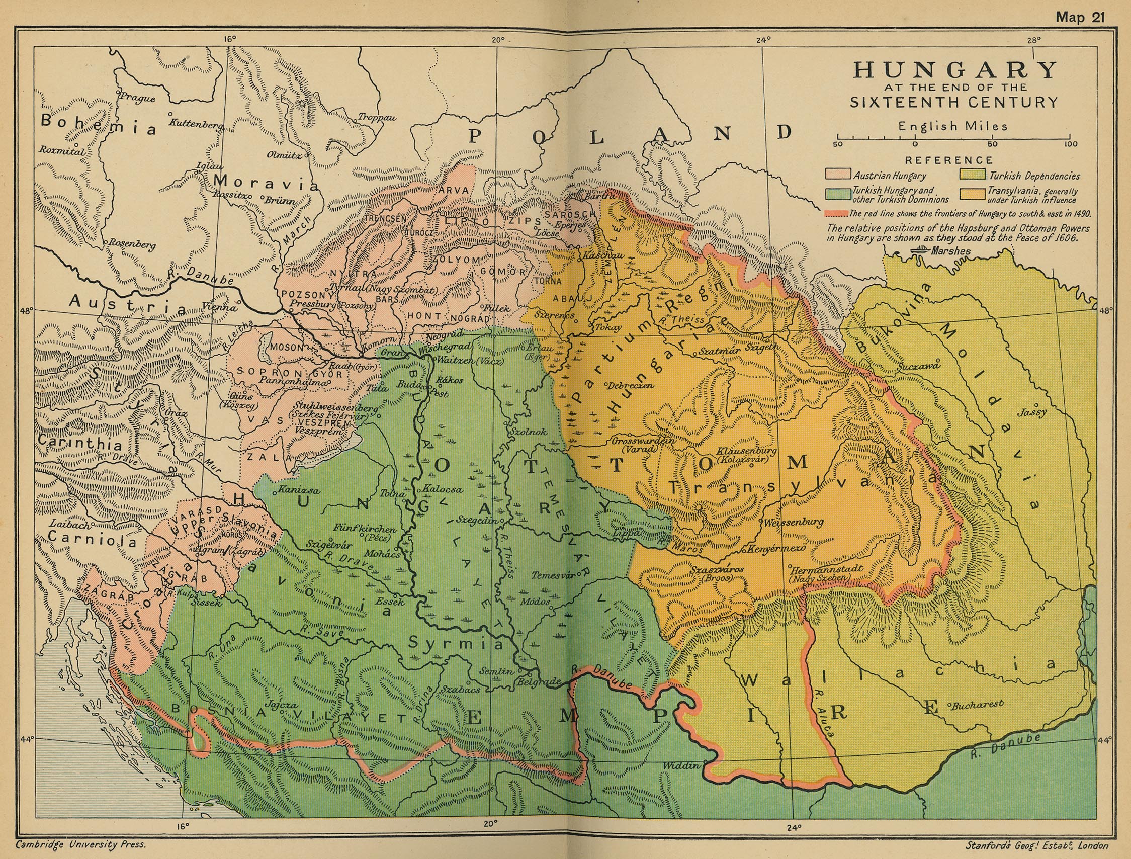
Magyar: Magyarország térképe a 16. század végén.
English: Hungary_16_century |
| তারিখ | |
| উৎস | http://www.lib.utexas.edu/maps/historical/ward_1912/hungary_16_century.jpg |
| লেখক | Az atlasz szerkesztői: Sir Adolphus William Ward, G.W. Prothero, Sir Stanley Mordaunt Leathes, and E.A. Benians. |
লাইসেন্স প্রদান
|
এই কর্মটি এর উৎস দেশে পাবলিক ডোমেইনে রয়েছে এবং অন্যান্য দেশ ও অঞ্চলে যেখানে কপিরাটের সময়সীমা হচ্ছে লেখকের জীবন যোগ ৭০ বছর বা তাঁর কম।
| |
| এই ফাইলটি কপিরাইট আইনের আওতায় জানা সকল বাধানিষেধ মুক্ত বলে চিহ্নিত হয়েছে, যার মধ্যে সম্পর্কিত সকল স্বত্ব ও নেইবারিং সত্ত্ব সংযুক্ত। | |
ফাইলের ইতিহাস
যেকোনো তারিখ/সময়ে ক্লিক করে দেখুন ফাইলটি তখন কী অবস্থায় ছিল।
| তারিখ/সময় | সংক্ষেপচিত্র | মাত্রা | ব্যবহারকারী | মন্তব্য | |
|---|---|---|---|---|---|
| বর্তমান | ০৩:৫১, ২৯ মে ২০২৩ | | ২,২৪৯ × ১,৭০৮ (১.২ মেগাবাইট) | Sepultura | Jobb. |
| ১৫:২৪, ৫ মে ২০১০ |  | ২,২৪৯ × ১,৭০৮ (৯৯৬ কিলোবাইট) | Szajci | {{Information |Description={{hu|1=Magyarország térképe a 16. század végén.}} {{en|1=Hungary_16_century}} |Source=http://www.lib.utexas.edu/maps/historical/ward_1912/hungary_16_century.jpg |Author=Az atlasz szerkesztői: Sir Adolphus William Ward, G. |
সংযোগসমূহ
নিচের পৃষ্ঠা(গুলো) থেকে এই ছবিতে সংযোগ আছে:
ফাইলের বৈশ্বিক ব্যবহার
নিচের অন্যান্য উইকিগুলো এই ফাইলটি ব্যবহার করে:
- arz.wikipedia.org-এ ব্যবহার
- en.wikipedia.org-এ ব্যবহার
- hu.wikipedia.org-এ ব্যবহার
- sh.wikipedia.org-এ ব্যবহার
- sr.wikipedia.org-এ ব্যবহার