চিত্র:EasternBloc BorderChange38-48.svg

এই SVG ফাইলের জন্য এই PNG প্রাকদর্শনের আকার: ৩৫২ × ৫৯৮ পিক্সেল। অন্যান্য আকারসমূহ: ১৪১ × ২৪০ পিক্সেল | ২৮২ × ৪৮০ পিক্সেল | ৪৫২ × ৭৬৮ পিক্সেল | ৬০২ × ১,০২৪ পিক্সেল | ১,২০৪ × ২,০৪৮ পিক্সেল | ৪০০ × ৬৮০ পিক্সেল।
পূর্ণ রেজোলিউশন (এসভিজি ফাইল, সাধারণত ৪০০ × ৬৮০ পিক্সেল, ফাইলের আকার: ১.৩৯ মেগাবাইট)
| এই ফাইলটি উইকিমিডিয়া কমন্স থেকে নেওয়া। সেখানের বর্ণনা পাতার বিস্তারিত নিম্নে দেখানো হলো। (সম্পাদনা)
|
| বিবরণ |
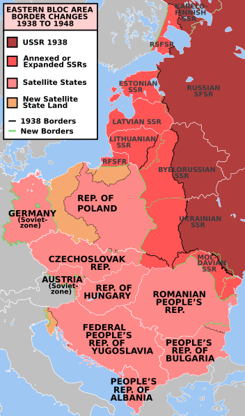
e* Description: Former Eastern Bloc area border changes between 1938 and 1948.
The border and other changes include:
|
||||||||
| উৎস | en.wiki | ||||||||
| লেখক | Mosedschurte | ||||||||
| অনুমতি (এ ফাইলের পুনঃব্যবহার) |
|
||||||||
| অন্যান্য সংস্করণ | العربيَّة, Türkçe |

ফাইলের ইতিহাস
যেকোনো তারিখ/সময়ে ক্লিক করে দেখুন ফাইলটি তখন কী অবস্থায় ছিল।
| তারিখ/সময় | সংক্ষেপচিত্র | মাত্রা | ব্যবহারকারী | মন্তব্য | |
|---|---|---|---|---|---|
| বর্তমান | ২২:২২, ১৭ জুলাই ২০২৩ | | ৪০০ × ৬৮০ (১.৩৯ মেগাবাইট) | Spesh531 | Corrected 1948-Moldavian SSR lines (white -> green). Thinned out 1948 Estonia & Latvia green lines to match the SSR-SSR border thickness |
| ০০:৪২, ৪ মার্চ ২০২১ |  | ৪০০ × ৬৮০ (১.৩৮ মেগাবাইট) | Spesh531 | Fixing Czechoslovakia before covered the Austro-Hungarian-Slovak border | |
| ০০:৩৯, ৪ মার্চ ২০২১ |  | ৪০০ × ৬৮০ (১.৩৮ মেগাবাইট) | Spesh531 | I missed Odessa! Which should be the neutral red like Moldova | |
| ১৩:৪৫, ৩ মার্চ ২০২১ |  | ৪০০ × ৬৮০ (১.৩৭ মেগাবাইট) | Spesh531 | Hiding internal borders of Yugoslavia and Czechoslovakia | |
| ১৩:৪০, ৩ মার্চ ২০২১ |  | ৪০০ × ৬৮০ (১.৩৩ মেগাবাইট) | Spesh531 | Overhaul of borders. Fixed Julian March. Added Austria occupied zone, Polish-Czech border changes, Austrian/Hungarian/Slovakian tripoint, and better detail in Karelia. | |
| ২৩:৩৩, ৯ মার্চ ২০১৯ |  | ৩৯৬ × ৬৪৩ (৫৮১ কিলোবাইট) | AndreyKva | Optimized. | |
| ১৩:০৭, ৯ জানুয়ারি ২০১১ |  | ৩৯৬ × ৬৪৩ (৭৬৫ কিলোবাইট) | Alokasta~commonswiki | Small changes + I changed east border of Poland: On the old version of this map there was the border after Polish-Soviet territorial exchange in 1951. More info: http://en.wikipedia.org/wiki/1951_Polish–Soviet_territorial_exchange | |
| ১২:৪১, ৯ জানুয়ারি ২০১১ |  | ৩৯৬ × ৬৪৩ (৭৬৩ কিলোবাইট) | Alokasta~commonswiki | I corrected the polish-german border - in 1938 the Hel Peninsula was the territory of Poland. I changed also the border between Poalnd and Free City of Danzig. I added a white line along the Polish coast. | |
| ০২:২১, ১৬ সেপ্টেম্বর ২০০৯ |  | ৩৯৬ × ৬৪৩ (৭৪৫ কিলোবাইট) | Stiepan Pietrov | {{Information |Description=e* Description: Former Eastern Bloc area border changes between 1938 and 1948. * Source: Map borders primarily based on [http://commons.wikimedia.org/wiki/File:EC12-1986_European_Community_map.svg] and [http://commons.wikime |
সংযোগসমূহ
নিচের পৃষ্ঠা(গুলো) থেকে এই ছবিতে সংযোগ আছে:
ফাইলের বৈশ্বিক ব্যবহার
নিচের অন্যান্য উইকিগুলো এই ফাইলটি ব্যবহার করে:
- af.wikipedia.org-এ ব্যবহার
- ar.wikipedia.org-এ ব্যবহার
- azb.wikipedia.org-এ ব্যবহার
- az.wikipedia.org-এ ব্যবহার
- bg.wikipedia.org-এ ব্যবহার
- ca.wikipedia.org-এ ব্যবহার
- cs.wikipedia.org-এ ব্যবহার
- da.wikipedia.org-এ ব্যবহার
- de.wikipedia.org-এ ব্যবহার
- el.wikipedia.org-এ ব্যবহার
- el.wiktionary.org-এ ব্যবহার
- en.wikipedia.org-এ ব্যবহার
- Molotov–Ribbentrop Pact
- World War II
- Eastern Bloc
- History of the United States (1945–1964)
- Cold War
- Origins of the Cold War
- History of the Soviet Union (1927–1953)
- Reinhard Gehlen
- List of national border changes (1914–present)
- Aftermath of World War II
- Military occupations by the Soviet Union
- Key events of the 20th century
- Soviet famine of 1946–1947
- Gehlen Organization
- Political warfare
- User:JacksonKo/ideology
- User:Paul Siebert/sandbox
- User:Falcaorib
- User:Shafin10555/sandbox
- User:Hmmmmm maybe/sandbox
- Cold War (1947–1948)
- Draft:World War II (Draft)
- en.wikiquote.org-এ ব্যবহার
- eo.wikiquote.org-এ ব্যবহার
- es.wikipedia.org-এ ব্যবহার
- et.wikipedia.org-এ ব্যবহার
- eu.wikipedia.org-এ ব্যবহার
- fa.wikipedia.org-এ ব্যবহার
- fi.wikipedia.org-এ ব্যবহার
- fr.wikipedia.org-এ ব্যবহার
- gl.wikipedia.org-এ ব্যবহার
- hif.wikipedia.org-এ ব্যবহার
- hy.wikipedia.org-এ ব্যবহার
এই ফাইলের অন্যান্য বৈশ্বিক ব্যবহার দেখুন।