চিত্র:Democratic Republic of Georgia map.jpg
এই প্রাকদর্শনের আকার: ৮০০ × ৫৬১ পিক্সেল। অন্যান্য আকারসমূহ: ৩২০ × ২২৪ পিক্সেল | ৬৪০ × ৪৪৮ পিক্সেল | ১,০২৪ × ৭১৮ পিক্সেল | ১,২১৩ × ৮৫০ পিক্সেল।
পূর্ণ রেজোলিউশন (১,২১৩ × ৮৫০ পিক্সেল, ফাইলের আকার: ৪৪২ কিলোবাইট, এমআইএমই ধরন: image/jpeg)
| এই ফাইলটি উইকিমিডিয়া কমন্স থেকে নেওয়া। সেখানের বর্ণনা পাতার বিস্তারিত নিম্নে দেখানো হলো। (সম্পাদনা)
|

|
This history map image could be re-created using vector graphics as an SVG file. This has several advantages; see Commons:Media for cleanup for more information. If an SVG form of this image is available, please upload it and afterwards replace this template with
{{vector version available|new image name}}.
It is recommended to name the SVG file “Democratic Republic of Georgia map.svg”—then the template Vector version available (or Vva) does not need the new image name parameter. |


সারাংশ
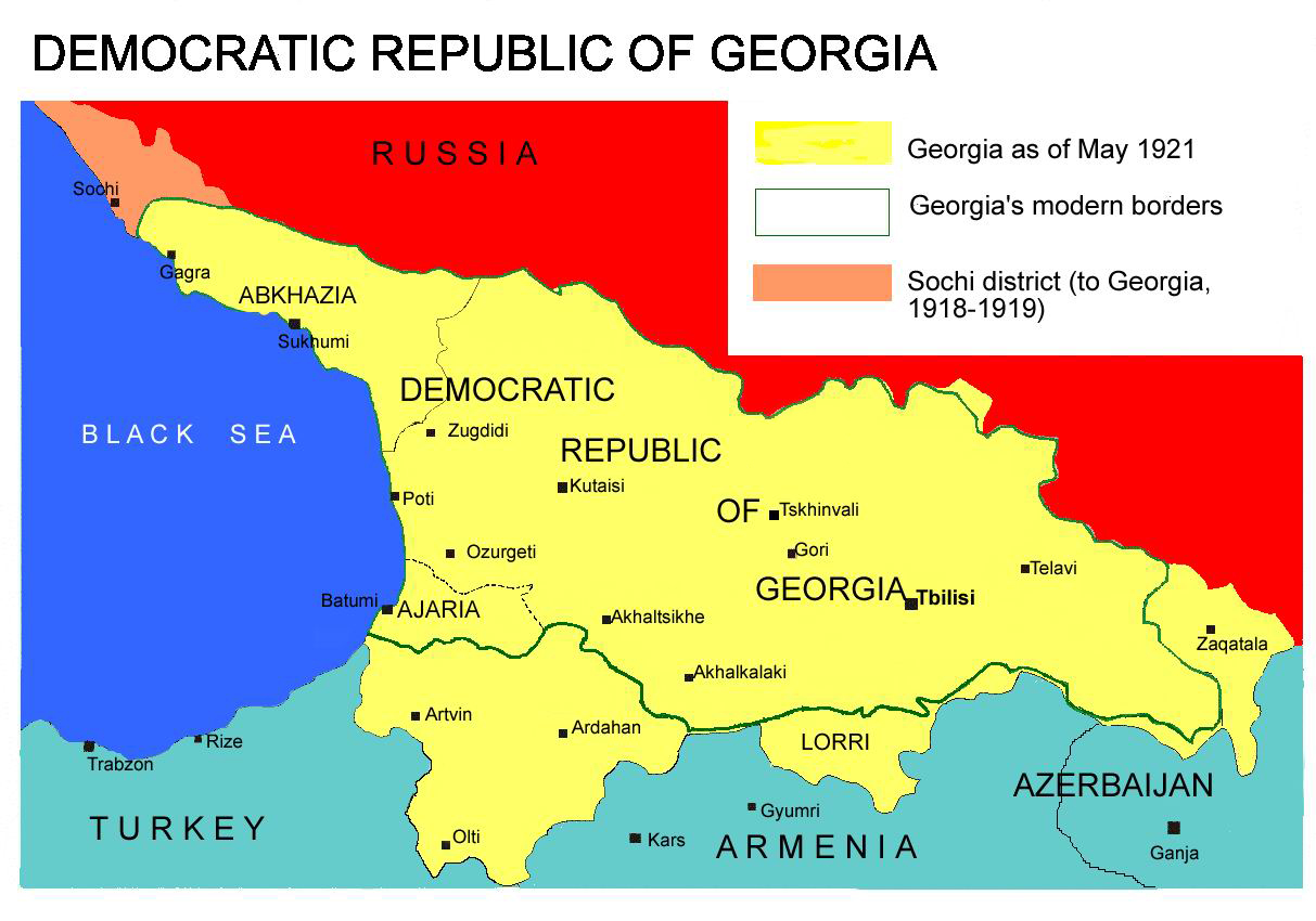
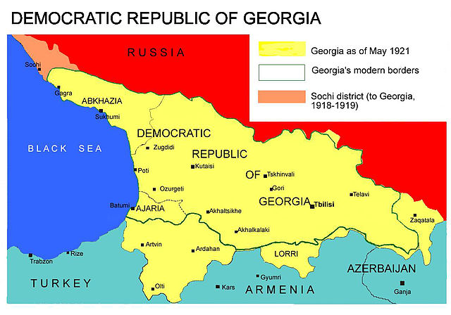
Democratic Republic of Georgia map, 1918-1921
Source: english wikipedia
Uploaded by user:Kober
লাইসেন্স প্রদান
| আমি, এই কাজের স্বত্বাধিকারী, এতদ্দ্বারা আমি এই কাজকে পাবলিক ডোমেইন লাইসেন্সের আওতায় প্রকাশ করলাম। এটি বিশ্বব্যাপী প্রযোজ্য হবে। কিছু দেশে এটি আইনত সিদ্ধ নাও হতে পারে, যদি তাই হয়: আমি যে-কাউকে এই কাজটি যেকোনো উদ্দেশ্যে, বিনাশর্তে ব্যবহারের অনুমতি প্রদান করছি, যদি না সেই শর্তগুলো আইনত প্রয়োজনীয় হয়। |
ফাইলের ইতিহাস
যেকোনো তারিখ/সময়ে ক্লিক করে দেখুন ফাইলটি তখন কী অবস্থায় ছিল।
| তারিখ/সময় | সংক্ষেপচিত্র | মাত্রা | ব্যবহারকারী | মন্তব্য | |
|---|---|---|---|---|---|
| বর্তমান | ১৩:২৬, ৭ এপ্রিল ২০১৩ | | ১,২১৩ × ৮৫০ (৪৪২ কিলোবাইট) | Giorgi Balakhadze | At that time (May, 1921 year) there was no South Ossetia, it was created in 1922. |
| ১৩:২১, ৭ এপ্রিল ২০১৩ |  | ১,২১৩ × ৮৫০ (৪৪২ কিলোবাইট) | Giorgi Balakhadze | Reverted to version as of 13:08, 7 April 2013 | |
| ১৩:১৫, ৭ এপ্রিল ২০১৩ |  | ১,২১৩ × ৮৫০ (৪৪২ কিলোবাইট) | Giorgi Balakhadze | At that time (1921 year) there was no South Ossetia, it was created 1922. | |
| ১৩:০৮, ৭ এপ্রিল ২০১৩ |  | ১,২১৩ × ৮৫০ (৪৪২ কিলোবাইট) | Giorgi Balakhadze | At that time (1921 year) there was no South Osetia. | |
| ১৬:৪৬, ২৬ ডিসেম্বর ২০০৫ |  | ১,২১৩ × ৮৫০ (১১১ কিলোবাইট) | Hardscarf | Democratic Republic of Georgia map, 1918-1921 Source: [http://en.wikipedia.org/wiki/Image:Democratic_Republic_of_Georgia_map.jpg english wikipedia] Uploaded by [http://en.wikipedia.org/wiki/User:Kober user:Kober] Category:Historical maps of Georgia |
সংযোগসমূহ
নিচের পৃষ্ঠা(গুলো) থেকে এই ছবিতে সংযোগ আছে:
ফাইলের বৈশ্বিক ব্যবহার
নিচের অন্যান্য উইকিগুলো এই ফাইলটি ব্যবহার করে:
- bg.wikipedia.org-এ ব্যবহার
- da.wikipedia.org-এ ব্যবহার
- de.wikipedia.org-এ ব্যবহার
- en.wikipedia.org-এ ব্যবহার
- en.wikibooks.org-এ ব্যবহার
- fa.wikipedia.org-এ ব্যবহার
- id.wikipedia.org-এ ব্যবহার
- ka.wikipedia.org-এ ব্যবহার
- lt.wikipedia.org-এ ব্যবহার
- pl.wikipedia.org-এ ব্যবহার
- pnb.wikipedia.org-এ ব্যবহার
- pt.wikipedia.org-এ ব্যবহার
- ru.wikipedia.org-এ ব্যবহার
- sk.wikipedia.org-এ ব্যবহার
- sr.wikipedia.org-এ ব্যবহার
- tr.wikipedia.org-এ ব্যবহার
- uk.wikipedia.org-এ ব্যবহার
- ur.wikipedia.org-এ ব্যবহার
- zh.wikipedia.org-এ ব্যবহার