চিত্র:Dalriada.jpg
এর চেয়ে বেশি রেজোলিউশন লভ্য নয়।
Dalriada.jpg (৫০৯ × ৫৩১ পিক্সেল, ফাইলের আকার: ৩৪ কিলোবাইট, এমআইএমই ধরন: image/jpeg)
| এই ফাইলটি উইকিমিডিয়া কমন্স থেকে নেওয়া। সেখানের বর্ণনা পাতার বিস্তারিত নিম্নে দেখানো হলো। (সম্পাদনা)
|
সারাংশ
| বিবরণ |
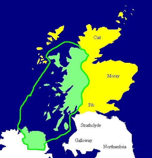
English: Extent of the Kingdom of Dál Riata (in green), c. AD 590. Yellow areas show occupation by the Picts.
Español: Mapa de Dalriada hacia el año 590. Las regiones pictas están marcadas en amarillo. |
| উৎস | Copied from en:Image:Dalriada.jpg. |
| লেখক | en:User:Briangotts |


|
This historical map image could be re-created using vector graphics as an SVG file. This has several advantages; see Commons:Media for cleanup for more information. If an SVG form of this image is available, please upload it and afterwards replace this template with
{{vector version available|new image name}}.
It is recommended to name the SVG file “Dalriada.svg”—then the template Vector version available (or Vva) does not need the new image name parameter. |
লাইসেন্স প্রদান
| এই কাজের প্রণেতা Briangotts কাজটি পাবলিক ডোমেইনে প্রকাশ করেছেন। এটি বিশ্বব্যাপী প্রযোজ্য হবে। কিছু দেশে এটি আইনত সিদ্ধ নাও হতে পারে, যদি তাই হয়: |
ফাইলের ইতিহাস
যেকোনো তারিখ/সময়ে ক্লিক করে দেখুন ফাইলটি তখন কী অবস্থায় ছিল।
| তারিখ/সময় | সংক্ষেপচিত্র | মাত্রা | ব্যবহারকারী | মন্তব্য | |
|---|---|---|---|---|---|
| বর্তমান | ১৫:৪৯, ২৭ সেপ্টেম্বর ২০০৫ | | ৫০৯ × ৫৩১ (৩৪ কিলোবাইট) | R | Copied from en:Image:Dalriada.jpg. Author: en:User:Briangotts. Extent of the Kingdom of Dalriada (in green), c.590 CE. Yellow areas show occupation by the Picts. {{PD}} |
সংযোগসমূহ
নিচের পৃষ্ঠা(গুলো) থেকে এই ছবিতে সংযোগ আছে:
ফাইলের বৈশ্বিক ব্যবহার
নিচের অন্যান্য উইকিগুলো এই ফাইলটি ব্যবহার করে:
- ar.wikipedia.org-এ ব্যবহার
- ast.wikipedia.org-এ ব্যবহার
- az.wikipedia.org-এ ব্যবহার
- br.wikipedia.org-এ ব্যবহার
- ca.wikipedia.org-এ ব্যবহার
- cs.wikipedia.org-এ ব্যবহার
- cy.wikipedia.org-এ ব্যবহার
- da.wikipedia.org-এ ব্যবহার
- de.wikipedia.org-এ ব্যবহার
- en.wikipedia.org-এ ব্যবহার
- es.wikipedia.org-এ ব্যবহার
- eu.wikipedia.org-এ ব্যবহার
- fi.wikipedia.org-এ ব্যবহার
- fr.wikipedia.org-এ ব্যবহার
- gd.wikipedia.org-এ ব্যবহার
- gl.wikipedia.org-এ ব্যবহার
- it.wikipedia.org-এ ব্যবহার
- nds.wikipedia.org-এ ব্যবহার
- nl.wikipedia.org-এ ব্যবহার
- no.wikipedia.org-এ ব্যবহার
- pl.wikipedia.org-এ ব্যবহার
- pt.wikipedia.org-এ ব্যবহার
- ro.wikipedia.org-এ ব্যবহার
- ru.wikipedia.org-এ ব্যবহার
- sv.wikipedia.org-এ ব্যবহার
- uk.wikipedia.org-এ ব্যবহার
এই ফাইলের অন্যান্য বৈশ্বিক ব্যবহার দেখুন।