চিত্র:CIS (orthographic projection).svg

এই SVG ফাইলের জন্য এই PNG প্রাকদর্শনের আকার: ৫৪১ × ৫৪১ পিক্সেল। অন্যান্য আকারসমূহ: ২৪০ × ২৪০ পিক্সেল | ৪৮০ × ৪৮০ পিক্সেল | ৭৬৮ × ৭৬৮ পিক্সেল | ১,০২৪ × ১,০২৪ পিক্সেল | ২,০৪৮ × ২,০৪৮ পিক্সেল।
পূর্ণ রেজোলিউশন (এসভিজি ফাইল, সাধারণত ৫৪১ × ৫৪১ পিক্সেল, ফাইলের আকার: ৫৫৮ কিলোবাইট)
| এই ফাইলটি উইকিমিডিয়া কমন্স থেকে নেওয়া। সেখানের বর্ণনা পাতার বিস্তারিত নিম্নে দেখানো হলো। (সম্পাদনা)
|
.svg?uselang=bn)
.svg&action=edit)
সারাংশ
| বিবরণ |
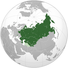
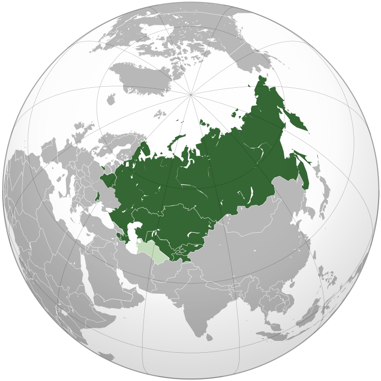
Čeština: Společenství nezávislých států
English: Orthographic projection of Commonwealth of Independent States.
Українська: Співдружність Незалежних Держав |
| তারিখ | |
| উৎস | নিজের কাজ |
| লেখক | Dag13 |
| SVG genesis | এই W3C-অবৈধ মানচিত্রটি Inkscape দিয়ে তৈরি করা হয়েছে। SVG watermarked with invisible embedded text. |
লাইসেন্স প্রদান
| This map is ineligible for copyright and therefore in the public domain, because it consists entirely of information that is common property and contains no original authorship. For more information, see Commons:Threshold of originality § Maps.
|
ফাইলের ইতিহাস
যেকোনো তারিখ/সময়ে ক্লিক করে দেখুন ফাইলটি তখন কী অবস্থায় ছিল।
.svg&dir=prev)
.svg&offset=20200121005429)
.svg&offset=&limit=20)
.svg&offset=&limit=50)
.svg&offset=&limit=100)
.svg&offset=&limit=250)
.svg&offset=&limit=500)
| তারিখ/সময় | সংক্ষেপচিত্র | মাত্রা | ব্যবহারকারী | মন্তব্য | |
|---|---|---|---|---|---|
| বর্তমান | ২০:৪৫, ১৮ মে ২০২১ | | ৫৪১ × ৫৪১ (৫৫৮ কিলোবাইট) | ThebeOkonma | Revert to correct version - Crimea is internationally recognised (e.g. by the UN) as part of Ukraine |
| ১৬:৩৪, ৯ সেপ্টেম্বর ২০২০ |  | ৫৪১ × ৫৪১ (৬০৯ কিলোবাইট) | Compu wiki | Reverted to version as of 15:04, 7 August 2020 (UTC) | |
| ১২:৫৪, ২ সেপ্টেম্বর ২০২০ |  | ৫৪১ × ৫৪১ (৫৫৮ কিলোবাইট) | Goo3 | Well, it really does. Along with UN, NATO, USA, EU etc. | |
| ১৫:০৪, ৭ আগস্ট ২০২০ |  | ৫৪১ × ৫৪১ (৬০৯ কিলোবাইট) | Compu wiki | Reverted to version as of 11:47, 15 July 2020 (UTC) The whole world does not recognize the territorial integrity of Ukraine. | |
| ১৬:৩৩, ২৯ জুলাই ২০২০ |  | ৫৪১ × ৫৪১ (৫৫৮ কিলোবাইট) | Goo3 | Crimea is a globally recognized a a Ukrainian territory, which is not a member of this organization. Reverting to a correct version | |
| ১১:৪৭, ১৫ জুলাই ২০২০ |  | ৫৪১ × ৫৪১ (৬০৯ কিলোবাইট) | Compu wiki | Reverted to version as of 13:02, 23 January 2020 (UTC) | |
| ১১:৫৩, ১৪ জুলাই ২০২০ |  | ৫৪১ × ৫৪১ (৫৫৮ কিলোবাইট) | Goo3 | Crimea is not disputed, it's annexed by Russia due to UN and recognizes as Ukraine by international law. Also, Ukraine is outside the CIS, uploaded a correct map. | |
| ১৩:০২, ২৩ জানুয়ারি ২০২০ |  | ৫৪১ × ৫৪১ (৬০৯ কিলোবাইট) | Rob984 | Reverted to version as of 20:53, 27 May 2018 (UTC) Ukraine has de facto quit. It is not an associate member, and does not participate in the organisation. | |
| ১৫:৪৭, ২২ জানুয়ারি ২০২০ |  | ৫৪১ × ৫৪১ (৬১১ কিলোবাইট) | Compu wiki | Reverted to version as of 07:09, 7 September 2019 (UTC) | |
| ০০:৫৪, ২১ জানুয়ারি ২০২০ |  | ৫৪১ × ৫৪১ (৬০৯ কিলোবাইট) | Homme | Reverted to version as of 05:40, 10 June 2018 (UTC) |
সংযোগসমূহ
নিচের পৃষ্ঠা(গুলো) থেকে এই ছবিতে সংযোগ আছে:
ফাইলের বৈশ্বিক ব্যবহার
নিচের অন্যান্য উইকিগুলো এই ফাইলটি ব্যবহার করে:
- af.wikipedia.org-এ ব্যবহার
- als.wikipedia.org-এ ব্যবহার
- be-tarask.wikipedia.org-এ ব্যবহার
- be.wikipedia.org-এ ব্যবহার
- bxr.wikipedia.org-এ ব্যবহার
- cdo.wikipedia.org-এ ব্যবহার
- ckb.wikipedia.org-এ ব্যবহার
- cs.wikipedia.org-এ ব্যবহার
- en.wikipedia.org-এ ব্যবহার
- en.wikivoyage.org-এ ব্যবহার
- et.wikipedia.org-এ ব্যবহার
- he.wikipedia.org-এ ব্যবহার
- it.wikivoyage.org-এ ব্যবহার
- ja.wikipedia.org-এ ব্যবহার
- kk.wikipedia.org-এ ব্যবহার
- kw.wikipedia.org-এ ব্যবহার
- ky.wikipedia.org-এ ব্যবহার
- la.wikipedia.org-এ ব্যবহার
- lv.wikipedia.org-এ ব্যবহার
- mk.wikipedia.org-এ ব্যবহার
- nl.wikipedia.org-এ ব্যবহার
- pl.wikipedia.org-এ ব্যবহার
- pt.wikipedia.org-এ ব্যবহার
- ro.wikipedia.org-এ ব্যবহার
- ro.wikivoyage.org-এ ব্যবহার
- rue.wikipedia.org-এ ব্যবহার
- ru.wikipedia.org-এ ব্যবহার
- sco.wikipedia.org-এ ব্যবহার
- sd.wikipedia.org-এ ব্যবহার
- simple.wikipedia.org-এ ব্যবহার
- sk.wikipedia.org-এ ব্যবহার
- sq.wikipedia.org-এ ব্যবহার
- sr.wikipedia.org-এ ব্যবহার
এই ফাইলের অন্যান্য বৈশ্বিক ব্যবহার দেখুন।
.svg)
.svg)