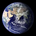
চিত্র:BlueMarble-2001-2002.jpg

এই প্রাকদর্শনের আকার: ৮০০ × ৪০০ পিক্সেল। অন্যান্য আকারসমূহ: ৩২০ × ১৬০ পিক্সেল | ৬৪০ × ৩২০ পিক্সেল | ১,০২৪ × ৫১২ পিক্সেল | ১,২৮০ × ৬৪০ পিক্সেল | ২,৫৬০ × ১,২৮০ পিক্সেল | ৪,০৯৬ × ২,০৪৮ পিক্সেল।
পূর্ণ রেজোলিউশন (৪,০৯৬ × ২,০৪৮ পিক্সেল, ফাইলের আকার: ১.২২ মেগাবাইট, এমআইএমই ধরন: image/jpeg)
ফাইলের ইতিহাস
যেকোনো তারিখ/সময়ে ক্লিক করে দেখুন ফাইলটি তখন কী অবস্থায় ছিল।
| তারিখ/সময় | সংক্ষেপচিত্র | মাত্রা | ব্যবহারকারী | মন্তব্য | |
|---|---|---|---|---|---|
| বর্তমান | ২২:১৪, ২০ ডিসেম্বর ২০০৯ |  | ৪,০৯৬ × ২,০৪৮ (১.২২ মেগাবাইট) | Apoc2400 | High resolution. |
| ০২:১০, ৩ সেপ্টেম্বর ২০০৫ |  | ৪০৫ × ২০৩ (১৯ কিলোবাইট) | Saperaud~commonswiki | NASA created these two images to exhibit high-resolution global composites of Moderate Resolution Imaging Spectroradiometer [http://modarch.gsfc.nasa.gov (MODIS)] data. The land surface data were acquired from June through September of 2001. The clouds we |
সংযোগসমূহ
নিচের পৃষ্ঠা(গুলো) থেকে এই ছবিতে সংযোগ আছে:
ফাইলের বৈশ্বিক ব্যবহার
নিচের অন্যান্য উইকিগুলো এই ফাইলটি ব্যবহার করে:
- af.wikipedia.org-এ ব্যবহার
- ar.wikipedia.org-এ ব্যবহার
- ast.wikipedia.org-এ ব্যবহার
- az.wikipedia.org-এ ব্যবহার
- ba.wikipedia.org-এ ব্যবহার
- be.wikipedia.org-এ ব্যবহার
- bh.wikipedia.org-এ ব্যবহার
- bo.wikipedia.org-এ ব্যবহার
- bs.wikipedia.org-এ ব্যবহার
- ca.wikipedia.org-এ ব্যবহার
- cs.wikipedia.org-এ ব্যবহার
- cy.wikipedia.org-এ ব্যবহার
- da.wikipedia.org-এ ব্যবহার
- de.wikipedia.org-এ ব্যবহার
- diq.wikipedia.org-এ ব্যবহার
- el.wikipedia.org-এ ব্যবহার
- en.wikipedia.org-এ ব্যবহার
- Marine biology
- Environmental movement
- Environmental science
- Twin Earth thought experiment
- Underwater environment
- The Blue Marble
- Ecosystem diversity
- Habitable zone
- Environmental history
- Origin of water on Earth
- Portal:Marine life
- Portal:Environment
- Portal:Environment/Selected article
- Portal:Environment/Selected article/14
- Sea
- Talk:Sustainability/Archive 8
- User:Nick carson/sandbox
- Talk:Sustainability/Lead
- Talk:Sustainability/Archive 25
- Talk:Sustainability/Archive 27
- Wikipedia:Reference desk/Archives/Science/2010 January 29
এই ফাইলের অন্যান্য বৈশ্বিক ব্যবহার দেখুন।


