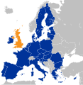
চিত্র:Location map of the United Kingdom and the European Union.svg

এই SVG ফাইলের জন্য এই PNG প্রাকদর্শনের আকার: ৫৮৭ × ৬০০ পিক্সেল। অন্যান্য আকারসমূহ: ২৩৫ × ২৪০ পিক্সেল | ৪৭০ × ৪৮০ পিক্সেল | ৭৫২ × ৭৬৮ পিক্সেল | ১,০০২ × ১,০২৪ পিক্সেল | ২,০০৪ × ২,০৪৮ পিক্সেল | ৫৯৩ × ৬০৬ পিক্সেল।
পূর্ণ রেজোলিউশন (এসভিজি ফাইল, সাধারণত ৫৯৩ × ৬০৬ পিক্সেল, ফাইলের আকার: ৭০৮ কিলোবাইট)
ফাইলের ইতিহাস
যেকোনো তারিখ/সময়ে ক্লিক করে দেখুন ফাইলটি তখন কী অবস্থায় ছিল।
| তারিখ/সময় | সংক্ষেপচিত্র | মাত্রা | ব্যবহারকারী | মন্তব্য | |
|---|---|---|---|---|---|
| বর্তমান | ১০:১০, ২৭ ডিসেম্বর ২০২২ |  | ৫৯৩ × ৬০৬ (৭০৮ কিলোবাইট) | Iktsokh | Correction of borders |
| ০৩:০৩, ২৭ মার্চ ২০১৯ |  | ৫৯৩ × ৬০৬ (৭০২ কিলোবাইট) | Nice4What | Reverted to version as of 08:03, 28 August 2016 (UTC) Northern Cyprus is shown as part as Cyprus in all other EU maps | |
| ১৬:৫৫, ২ ফেব্রুয়ারি ২০১৭ |  | ৫৯৩ × ৬০৬ (৭০৪ কিলোবাইট) | RaviC | Shaded regions with partial EU treaty application (Customs Union) per https://www.gov.uk/government/uploads/system/uploads/attachment_data/file/588948/The_United_Kingdoms_exit_from_and_partnership_with_the_EU_Web.pdf | |
| ০৫:৫২, ২৯ আগস্ট ২০১৬ |  | ৫৯৩ × ৬০৬ (৭০৪ কিলোবাইট) | Turnless | Reverted to version as of 12:49, 25 June 2016 (UTC) COM:OVERWRITE violation, you can create a new map if you'd like. | |
| ০৮:০৩, ২৮ আগস্ট ২০১৬ |  | ৫৯৩ × ৬০৬ (৭০২ কিলোবাইট) | Bazonka | Northern Cyprus is de jure part of the EU | |
| ১২:৪৯, ২৫ জুন ২০১৬ |  | ৫৯৩ × ৬০৬ (৭০৪ কিলোবাইট) | Steinsplitter | Reverted to version as of 17:57, 18 June 2016 (UTC): COM:OVERWRITE violation | |
| ১২:০৮, ২৫ জুন ২০১৬ |  | ৭৯২ × ৭৯২ (২.৮৭ মেগাবাইট) | ThiefOfBagdad | Full EU view | |
| ১৭:৫৭, ১৮ জুন ২০১৬ |  | ৫৯৩ × ৬০৬ (৭০৪ কিলোবাইট) | RaviC | + Gib | |
| ০৫:৩৭, ১৬ জুন ২০১৬ |  | ৫৯৩ × ৬০৬ (৭০৩ কিলোবাইট) | Turnless | Update layout | |
| ১০:৩০, ২৭ মে ২০১৬ |  | ৬৩২ × ৬৩৭ (৭৬৫ কিলোবাইট) | Furfur | new color, better visibility |
সংযোগসমূহ
নিচের পৃষ্ঠা(গুলো) থেকে এই ছবিতে সংযোগ আছে:
ফাইলের বৈশ্বিক ব্যবহার
নিচের অন্যান্য উইকিগুলো এই ফাইলটি ব্যবহার করে:
- af.wikipedia.org-এ ব্যবহার
- ar.wikipedia.org-এ ব্যবহার
- ast.wikipedia.org-এ ব্যবহার
- az.wikipedia.org-এ ব্যবহার
- ba.wikipedia.org-এ ব্যবহার
- be.wikipedia.org-এ ব্যবহার
- bg.wikipedia.org-এ ব্যবহার
- bh.wikipedia.org-এ ব্যবহার
- br.wikipedia.org-এ ব্যবহার
- bs.wikipedia.org-এ ব্যবহার
- cs.wikipedia.org-এ ব্যবহার
- cy.wikipedia.org-এ ব্যবহার
- da.wikipedia.org-এ ব্যবহার
- de.wikipedia.org-এ ব্যবহার
- 2016
- Benutzer:Kallewirsch
- EU-Austritt des Vereinigten Königreichs
- Benutzer:Tmid
- Benutzer:Anton-kurt/Schaufenster 2016
- Wikipedia:Hauptseite/Archiv/24. Juni 2016
- Wikipedia:Hauptseite/Archiv/3. November 2016
- März 2017
- Wikipedia:Hauptseite/Archiv/29. März 2017
- Wikipedia:Kartenwerkstatt/Archiv/2017-04
- Wikipedia:Hauptseite/Archiv/20. Juni 2017
- Wikipedia:Hauptseite/Archiv/15. November 2018
- Wikipedia:Hauptseite/Archiv/25. November 2018
- Wikipedia:Hauptseite/Archiv/26. November 2018
- EU-Mitgliedschaft des Vereinigten Königreichs
- Wikipedia:Kurier/Ausgabe 2 2020
- Handels- und Kooperationsabkommen zwischen der Europäischen Union und dem Vereinigten Königreich
- Benutzer:Gabas/Meistaufgerufene Artikel
- din.wikipedia.org-এ ব্যবহার
- diq.wikipedia.org-এ ব্যবহার
- en.wikipedia.org-এ ব্যবহার
- User:ArcMachaon/sandbox
- Brexit
- Wikipedia:In the news/Candidates/June 2016
- Template talk:United Kingdom in the European Union
- Wikipedia:Top 25 Report/June 19 to 25, 2016
- Wikipedia:Wikipedia Signpost/2016-07-04/Traffic report
- Wikipedia:Wikipedia Signpost/Single/2016-07-04
- Wikipedia:Top 25 Report/June 26 to July 2, 2016
- Talk:Brexit/Archive 1
- Brexit negotiations
এই ফাইলের অন্যান্য বৈশ্বিক ব্যবহার দেখুন।