চিত্র:Trails of Tears en.png

এই প্রাকদর্শনের আকার: ৭৮৫ × ৬০০ পিক্সেল। অন্যান্য আকারসমূহ: ৩১৪ × ২৪০ পিক্সেল | ৬২৮ × ৪৮০ পিক্সেল | ১,০০৫ × ৭৬৮ পিক্সেল | ১,২৮০ × ৯৭৮ পিক্সেল | ২,০২৫ × ১,৫৪৭ পিক্সেল।
পূর্ণ রেজোলিউশন (২,০২৫ × ১,৫৪৭ পিক্সেল, ফাইলের আকার: ৩.০৪ মেগাবাইট, এমআইএমই ধরন: image/png)
| এই ফাইলটি উইকিমিডিয়া কমন্স থেকে নেওয়া। সেখানের বর্ণনা পাতার বিস্তারিত নিম্নে দেখানো হলো। (সম্পাদনা)
|
সারাংশ
| বিবরণ |
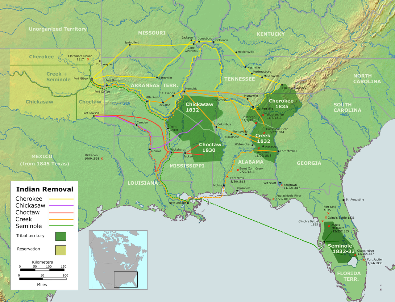
English: Map of the route of the Trails of Tears — depicting the route taken to relocate Native Americans from the Southeastern United States between 1836 and 1839.
|
||||
| তারিখ | |||||
| উৎস |
এটি ব্যবহার করে নিজের কাজ::
|
||||
| লেখক | User:Nikater | ||||
| অনুমতি (এ ফাইলের পুনঃব্যবহার) |
|
||||
| অন্যান্য সংস্করণ |
|

ফাইলের ইতিহাস
যেকোনো তারিখ/সময়ে ক্লিক করে দেখুন ফাইলটি তখন কী অবস্থায় ছিল।
| তারিখ/সময় | সংক্ষেপচিত্র | মাত্রা | ব্যবহারকারী | মন্তব্য | |
|---|---|---|---|---|---|
| বর্তমান | ১৮:৩৭, ৪ সেপ্টেম্বর ২০০৭ | | ২,০২৫ × ১,৫৪৭ (৩.০৪ মেগাবাইট) | Nikater | {{Information |Description=Trails of Tears (English version) |Source=Own work by Nikater, submitted to the public domain. Background map courtesy of Demis, www.demis.nl and Wilcomb E. Washburn (Hrsg.) ''Handbook of North American Indians.'' Vol. 4: Histor |
| ০৭:৫৫, ৪ সেপ্টেম্বর ২০০৭ |  | ২,০২৫ × ১,৫৪৭ (৩.০৪ মেগাবাইট) | Nikater | {{Information |Description=Trails of Tears (English version) |Source=Own work by Nikater, submitted to the public domain. Background map courtesy of Demis, www.demis.nl and Wilcomb E. Washburn (Hrsg.) ''Handbook of North American Indians.'' Vol. 4: Histor |
সংযোগসমূহ
নিচের পৃষ্ঠা(গুলো) থেকে এই ছবিতে সংযোগ আছে:
ফাইলের বৈশ্বিক ব্যবহার
নিচের অন্যান্য উইকিগুলো এই ফাইলটি ব্যবহার করে:
- af.wikipedia.org-এ ব্যবহার
- am.wikipedia.org-এ ব্যবহার
- ar.wikipedia.org-এ ব্যবহার
- bcl.wikiquote.org-এ ব্যবহার
- be.wikipedia.org-এ ব্যবহার
- bg.wikipedia.org-এ ব্যবহার
- ca.wikipedia.org-এ ব্যবহার
- Destí Manifest
- Neteja ètnica
- Andrew Jackson
- James Monroe
- Guerres índies
- Deportació dels indis dels Estats Units
- Camí de les Llàgrimes
- Territori Indi
- Tractat de Dancing Rabbit Creek
- Camí de les Llàgrimes choctaw
- Plantilla:Deportació ameríndia
- Tractat de Payne's Landing
- Indian Removal Act
- Tractat de Doak's Stand
- Tractat de Hopewell
- Tractat de Prairie du Chien
- Usuari:Carmallola/Neteja ètnica
- cs.wikipedia.org-এ ব্যবহার
- de.wikipedia.org-এ ব্যবহার
- en.wikipedia.org-এ ব্যবহার
- Indian removal
- Winfield Scott
- History of the United States
- Trail of Tears
- Five Civilized Tribes
- History of the Southern United States
- Portal:Oklahoma
- History of Oklahoma
- History of Arkansas
- Presidency of Andrew Jackson
- User talk:Kevin1776/Archive 3
- Aboriginal title in the United States
- Cherokee Nation (1794–1907)
- User:Boompole/sandbox
- Oklahoma Organic Act
- User:Joelton Ivson/Gather lists/24319 – Indígenas América do Norte
- User:Squeakinglemur/sandbox
- Indian commerce with early English colonists and the early United States
এই ফাইলের অন্যান্য বৈশ্বিক ব্যবহার দেখুন।