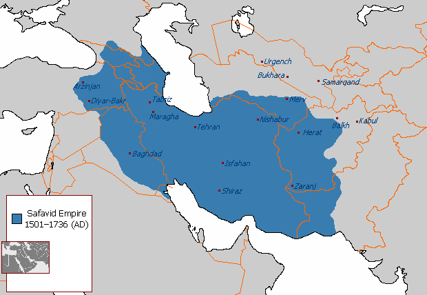
চিত্র:The maximum extent of the Safavid Empire under Shah Abbas I.png
The_maximum_extent_of_the_Safavid_Empire_under_Shah_Abbas_I.png (৬২০ × ৪২৮ পিক্সেল, ফাইলের আকার: ২০ কিলোবাইট, এমআইএমই ধরন: image/png)
ফাইলের ইতিহাস
যেকোনো তারিখ/সময়ে ক্লিক করে দেখুন ফাইলটি তখন কী অবস্থায় ছিল।
| তারিখ/সময় | সংক্ষেপচিত্র | মাত্রা | ব্যবহারকারী | মন্তব্য | |
|---|---|---|---|---|---|
| বর্তমান | ২১:০৩, ১ জানুয়ারি ২০১৮ |  | ৬২০ × ৪২৮ (২০ কিলোবাইট) | HistoryofIran | rv, take your concerns to the talk page |
| ২১:৫৪, ৩০ ডিসেম্বর ২০১৭ |  | ৬২০ × ৪২৮ (২৪ কিলোবাইট) | Qizilbash | Eastern Anatolia has never been under the control of Shah Abbas. After Shah Ismail this region has always been under Ottoman control. | |
| ০৪:৫৬, ৭ জুলাই ২০১৫ |  | ৬২০ × ৪২৮ (২০ কিলোবাইট) | HistoryofIran | Removed disprutive edit from banned user. | |
| ০২:০৩, ২৩ জুন ২০১৫ |  | ৬২০ × ৪২৮ (২০ কিলোবাইট) | Artin Mehraban | the minor changes are examples of original research which is banned by wikipedia | |
| ০৪:০৯, ২২ জুন ২০১৫ |  | ৬২০ × ৪২৮ (২০ কিলোবাইট) | LouisAragon | they didn't rule such area under Abbas sigh. Stop being such a nuisance really. | |
| ২৩:১২, ২০ জুন ২০১৫ |  | ৬২০ × ৪২৮ (২৭ কিলোবাইট) | Artin Mehraban | changed the map size | |
| ২৩:০৩, ২০ জুন ২০১৫ |  | ৫৮২ × ৪০১ (২৫ কিলোবাইট) | Artin Mehraban | It was well known Shah Abbas took daghestan | |
| ২০:৫৭, ২০ জুন ২০১৫ |  | ৫৮২ × ৪০১ (২৪ কিলোবাইট) | Artin Mehraban | small edits | |
| ১৯:২৪, ২০ জুন ২০১৫ |  | ৫৮২ × ৪০১ (২৩ কিলোবাইট) | Artin Mehraban | A few minor changes | |
| ০৪:০০, ২০ জুন ২০১৫ |  | ৫৮৫ × ৪১৪ (২২ কিলোবাইট) | Artin Mehraban | Better text for cities |
সংযোগসমূহ
নিচের পৃষ্ঠা(গুলো) থেকে এই ছবিতে সংযোগ আছে:
ফাইলের বৈশ্বিক ব্যবহার
নিচের অন্যান্য উইকিগুলো এই ফাইলটি ব্যবহার করে:
- af.wikipedia.org-এ ব্যবহার
- azb.wikipedia.org-এ ব্যবহার
- az.wikipedia.org-এ ব্যবহার
- cs.wikipedia.org-এ ব্যবহার
- el.wikipedia.org-এ ব্যবহার
- en.wikipedia.org-এ ব্যবহার
- Greater Iran
- Abbas II of Persia
- Iranian Armenia (1502–1828)
- Safavid Shirvan
- Safavid Karabakh
- Template:Safavid provinces
- Safavid Georgia
- Safavid Daghestan
- Erivan Province (Safavid Iran)
- User talk:EdJohnston/Archive 44
- User:LouisAragon/sandbox/Dagh
- Safavid Diyarbakr
- User:Falcaorib
- Baghdad Province (Safavid Empire)
- Safavid Talish
- Marie Petit
- Azerbaijan Province (Safavid Iran)
- Safavid Khuzestan
- Safavid Astarabad
- Safavid Lorestan
- Safavid Kandahar
- Safavid Kurdistan
- User:Kailanmapper/sandbox4
- User:Kailanmapper/sandbox5
- en.wikibooks.org-এ ব্যবহার
- et.wikipedia.org-এ ব্যবহার
- eu.wikipedia.org-এ ব্যবহার
- fa.wikipedia.org-এ ব্যবহার
এই ফাইলের অন্যান্য বৈশ্বিক ব্যবহার দেখুন।

