চিত্র:Satellite image of Philippines in March 2002.jpg

এই প্রাকদর্শনের আকার: ৪৬০ × ৬০০ পিক্সেল। অন্যান্য আকারসমূহ: ১৮৪ × ২৪০ পিক্সেল | ৩৬৮ × ৪৮০ পিক্সেল | ৫৮৯ × ৭৬৮ পিক্সেল | ৭৮৫ × ১,০২৪ পিক্সেল | ১,৫৭০ × ২,০৪৮ পিক্সেল | ৪,৬০০ × ৬,০০০ পিক্সেল।
পূর্ণ রেজোলিউশন (৪,৬০০ × ৬,০০০ পিক্সেল, ফাইলের আকার: ৩.৫৮ মেগাবাইট, এমআইএমই ধরন: image/jpeg)
| এই ফাইলটি উইকিমিডিয়া কমন্স থেকে নেওয়া। সেখানের বর্ণনা পাতার বিস্তারিত নিম্নে দেখানো হলো। (সম্পাদনা)
|
সারাংশ
| বিবরণ |
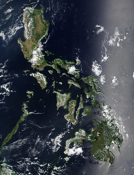
Satellite image of Philippines in March 2002. |
| তারিখ | |
| উৎস | http://visibleearth.nasa.gov/view_rec.php?id=2689 |
| লেখক | NASA |
লাইসেন্স প্রদান
| এই ফাইলটি পাবলিক ডোমেইনে আছে কারণ এটি শুধুমাত্র নাসা কর্তৃক নির্মিত হয়েছিল। নাসার কপিরাইট নীতি হচ্ছে যে "নাসা কর্তৃক উল্লেখ না থাকলে নাসার উপাদান কপিরাইট দ্বারা সুরক্ষিত নয়"। (Template:PD-USGov, নাসার কপিরাইট নীতির পাতা অথবা জেপিএল চিত্র ব্যবহারের নীতি দেখুন।) | ||
 |
সতর্কবার্তা:
|
ফাইলের ইতিহাস
যেকোনো তারিখ/সময়ে ক্লিক করে দেখুন ফাইলটি তখন কী অবস্থায় ছিল।
| তারিখ/সময় | সংক্ষেপচিত্র | মাত্রা | ব্যবহারকারী | মন্তব্য | |
|---|---|---|---|---|---|
| বর্তমান | ১১:৩২, ২১ ডিসেম্বর ২০০৪ | | ৪,৬০০ × ৬,০০০ (৩.৫৮ মেগাবাইট) | Hautala | {{PD-USGov-NASA}} Satellite image of Philippines in March 2002. Taken from NASA's Visible Earth http://visibleearth.nasa.gov/cgi-bin/viewrecord?12847 . Description: Red dots (or outlines in the high-resolution imagery) indicate MODIS9 detection of thermal |
সংযোগসমূহ
নিচের পৃষ্ঠা(গুলো) থেকে এই ছবিতে সংযোগ আছে:
ফাইলের বৈশ্বিক ব্যবহার
নিচের অন্যান্য উইকিগুলো এই ফাইলটি ব্যবহার করে:
- af.wikipedia.org-এ ব্যবহার
- bg.wikipedia.org-এ ব্যবহার
- ca.wikipedia.org-এ ব্যবহার
- da.wikipedia.org-এ ব্যবহার
- de.wikipedia.org-এ ব্যবহার
- de.wikinews.org-এ ব্যবহার
- en.wikipedia.org-এ ব্যবহার
- Outline of the Philippines
- Deforestation by continent
- Deforestation in the Philippines
- Wikipedia:Featured picture candidates/Satellite image of the Philippines
- Wikipedia:Featured picture candidates/September-2012
- Wikipedia:Featured picture candidates/February-2014
- Wikipedia:Featured picture candidates/Philippines (Satellite)
- en.wikiversity.org-এ ব্যবহার
- en.wiktionary.org-এ ব্যবহার
- fi.wikipedia.org-এ ব্যবহার
- gl.wikipedia.org-এ ব্যবহার
- he.wikipedia.org-এ ব্যবহার
- תבנית:הידעת? 5 בנובמבר - סדרה 2
- פורטל:ארצות הברית/הידעת?/קטעי הידעת
- פורטל:ארצות הברית/הידעת?/50
- פורטל:יפן/הידעת?/קטעי הידעת
- תבנית:הידעת? 5 בנובמבר 2014
- ויקיפדיה:הידעת?/2014/נובמבר
- ויקיפדיה:הידעת?/2016/נובמבר
- תבנית:הידעת? 5 בנובמבר 2016
- ויקיפדיה:הידעת?/2018/נובמבר
- תבנית:הידעת? 18 בנובמבר 2018
- תבנית:הידעת? 1 בנובמבר 2019
- ויקיפדיה:הידעת?/2019/נובמבר
- ויקיפדיה:הידעת?/2021/נובמבר
- תבנית:הידעת? 7 בנובמבר 2021
- פורטל:יפן/הידעת?/23
- תבנית:הידעת? 5 בנובמבר 2023
- ויקיפדיה:הידעת?/2023/נובמבר
- ht.wikipedia.org-এ ব্যবহার
- incubator.wikimedia.org-এ ব্যবহার
- mdf.wikipedia.org-এ ব্যবহার
- nl.wikipedia.org-এ ব্যবহার
- nl.wiktionary.org-এ ব্যবহার
- no.wikipedia.org-এ ব্যবহার
- pap.wikipedia.org-এ ব্যবহার
- pl.wikinews.org-এ ব্যবহার
- qu.wikipedia.org-এ ব্যবহার
- sk.wikipedia.org-এ ব্যবহার
- sm.wikipedia.org-এ ব্যবহার
- sr.wikinews.org-এ ব্যবহার
- trv.wikipedia.org-এ ব্যবহার
এই ফাইলের অন্যান্য বৈশ্বিক ব্যবহার দেখুন।