চিত্র:Satellite image of Denmark in July 2001.jpg

এই প্রাকদর্শনের আকার: ৮০০ × ৫৯৬ পিক্সেল। অন্যান্য আকারসমূহ: ৩২০ × ২৩৯ পিক্সেল | ৬৪০ × ৪৭৭ পিক্সেল | ১,০২৪ × ৭৬৩ পিক্সেল | ১,২৮০ × ৯৫৪ পিক্সেল | ১,৯০৫ × ১,৪২০ পিক্সেল।
পূর্ণ রেজোলিউশন (১,৯০৫ × ১,৪২০ পিক্সেল, ফাইলের আকার: ১৯০ কিলোবাইট, এমআইএমই ধরন: image/jpeg)
| এই ফাইলটি উইকিমিডিয়া কমন্স থেকে নেওয়া। সেখানের বর্ণনা পাতার বিস্তারিত নিম্নে দেখানো হলো। (সম্পাদনা)
|
| এই ফাইলটি পাবলিক ডোমেইনে আছে কারণ এটি শুধুমাত্র নাসা কর্তৃক নির্মিত হয়েছিল। নাসার কপিরাইট নীতি হচ্ছে যে "নাসা কর্তৃক উল্লেখ না থাকলে নাসার উপাদান কপিরাইট দ্বারা সুরক্ষিত নয়"। (Template:PD-USGov, নাসার কপিরাইট নীতির পাতা অথবা জেপিএল চিত্র ব্যবহারের নীতি দেখুন।) | ||
 |
সতর্কবার্তা:
|
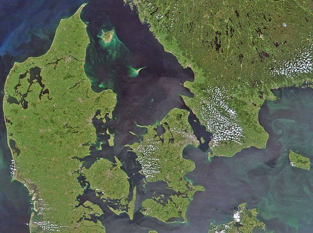
Satellite image of Denmark in July 2001. Cropped image, original taken from NASA's Visible Earth http://visibleearth.nasa.gov/view_rec.php?id=1909
- Interestingly, the Danish-German border is incorrectly placed. The line shown on the map has the correct shape, but is located c. 10 kilometres south of the current border. The line should have been positioned between the islands Rømø and Sylt in the west, and through the fjord to the east. Valentinian (talk) 17:09, 12 November 2006 (UTC)
ফাইলের ইতিহাস
যেকোনো তারিখ/সময়ে ক্লিক করে দেখুন ফাইলটি তখন কী অবস্থায় ছিল।
| তারিখ/সময় | সংক্ষেপচিত্র | মাত্রা | ব্যবহারকারী | মন্তব্য | |
|---|---|---|---|---|---|
| বর্তমান | ০৮:৩৯, ২৪ ফেব্রুয়ারি ২০০৮ | | ১,৯০৫ × ১,৪২০ (১৯০ কিলোবাইট) | XcepticZP | Color correction, ligthened up. Smaller file size due to better jpg compression. |
| ১৪:২২, ১০ এপ্রিল ২০০৫ |  | ১,৯০৫ × ১,৪২০ (৩৬৯ কিলোবাইট) | Hautala | {{PD-USGov-NASA}} Satellite image of Denmark in July 2001. Cropped image, original taken from NASA's Visible Earth http://visibleearth.nasa.gov/view_rec.php?id=1909 |
সংযোগসমূহ
নিচের পৃষ্ঠা(গুলো) থেকে এই ছবিতে সংযোগ আছে:
ফাইলের বৈশ্বিক ব্যবহার
নিচের অন্যান্য উইকিগুলো এই ফাইলটি ব্যবহার করে:
- af.wikipedia.org-এ ব্যবহার
- arz.wikipedia.org-এ ব্যবহার
- az.wikipedia.org-এ ব্যবহার
- be.wikipedia.org-এ ব্যবহার
- ca.wikipedia.org-এ ব্যবহার
- ceb.wikipedia.org-এ ব্যবহার
- ce.wikipedia.org-এ ব্যবহার
- cs.wikipedia.org-এ ব্যবহার
- da.wikipedia.org-এ ব্যবহার
- Diskussion:København
- Diskussion:Odense
- Diskussion:Hjørring
- Diskussion:Faaborg
- Diskussion:Barneholm
- Svæveflyveklubber i Danmark
- Diskussion:Frederiksberg
- Diskussion:Ærøskøbing
- Diskussion:Frederikssund
- Diskussion:Kalundborg
- Diskussion:Nykøbing Falster
- Skabelon:Klik
- Diskussion:Nivå
- Bruger:Sir48/Sandkasse
- Diskussion:Frederiksværk
- Diskussion:Djævleø
- Diskussion:Frederikshavn
- Diskussion:Lillerød
- Diskussion:Helsingør
- Diskussion:Hørsholm
- Diskussion:Roskilde
- Diskussion:Visborg (by)
- Diskussion:Rønne
- Diskussion:Svendborg
- Diskussion:Slagelse
- Portal:Danmark
- Portal:Danmark/Introtekst
- Diskussion:Næstved
- Diskussion:Fugleholm
- Diskussion:Nexø
- Diskussion:Nakskov
- Diskussion:Allinge-Sandvig
- Diskussion:Sorø
- Diskussion:Rudkøbing
- Diskussion:Lysbro (Silkeborg)
- Skabelondiskussion:Kortpositioner/doc
- Diskussion:Holbæk
- Diskussion:Halsted
- Diskussion:Fræer
এই ফাইলের অন্যান্য বৈশ্বিক ব্যবহার দেখুন।