চিত্র:Safavid Empire 1501 1722 AD.png
এর চেয়ে বেশি রেজোলিউশন লভ্য নয়।
Safavid_Empire_1501_1722_AD.png (৬২০ × ৪২৮ পিক্সেল, ফাইলের আকার: ২০ কিলোবাইট, এমআইএমই ধরন: image/png)
| এই ফাইলটি উইকিমিডিয়া কমন্স থেকে নেওয়া। সেখানের বর্ণনা পাতার বিস্তারিত নিম্নে দেখানো হলো। (সম্পাদনা)
|

|
This historical map image could be re-created using vector graphics as an SVG file. This has several advantages; see Commons:Media for cleanup for more information. If an SVG form of this image is available, please upload it and afterwards replace this template with
{{vector version available|new image name}}.
It is recommended to name the SVG file “Safavid Empire 1501 1722 AD.svg”—then the template Vector version available (or Vva) does not need the new image name parameter. |
সারাংশ
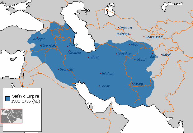
| বিবরণ | A map depicting the extent the Safavid Empire at its greatest extent under Ismail I. |
| তারিখ | ২৯ আগস্ট ২০০৭ (মূল আপলোডের তারিখ) |
| উৎস | নিজের কাজ |
| লেখক | ইংরেজি উইকিপিডিয়া-এর Arab League |
| অন্যান্য সংস্করণ | العربيَّة |
লাইসেন্স প্রদান
| এই কাজের প্রণেতা ইংরেজি উইকিপিডিয়া-এর Arab League কাজটি পাবলিক ডোমেইনে প্রকাশ করেছেন। এটি বিশ্বব্যাপী প্রযোজ্য হবে। কিছু দেশে এটি আইনত সিদ্ধ নাও হতে পারে, যদি তাই হয়: Arab League যে-কাউকে যেকোনো উদ্দেশ্যে, বিনাশর্তে এই কাজটি ব্যবহারের অনুমতি প্রদান করেন, যদি না সেই শর্তগুলো আইনত প্রয়োজনীয় হয়। |
মূল আপলোড লগ
en.wikipedia থেকে কমন্সে স্থানান্তরিত করা হয়েছে KureCewlik81 কর্তৃক।
মূল বিবরণ পাতাটি এখানে ছিল। নিম্নলিখিত সকল ব্যবহারকারীর নাম en.wikipedia-এ উল্লেখ করা ছিল।
- 2007-08-29 21:55 Arab League 620×429×8 (24314 bytes)
ফাইলের ইতিহাস
যেকোনো তারিখ/সময়ে ক্লিক করে দেখুন ফাইলটি তখন কী অবস্থায় ছিল।
| তারিখ/সময় | সংক্ষেপচিত্র | মাত্রা | ব্যবহারকারী | মন্তব্য | |
|---|---|---|---|---|---|
| বর্তমান | ২৩:০৮, ১ জানুয়ারি ২০১৮ | | ৬২০ × ৪২৮ (২০ কিলোবাইট) | HistoryofIran | No consensus has been reached. You own nothing on this site, neither do I. |
| ২২:৫৯, ১ জানুয়ারি ২০১৮ |  | ৬২০ × ৪২৮ (২৭ কিলোবাইট) | Qizilbash | Reverted. I don't know about your own maps. But the edits you have made here are historically incorrect. Borders regarding the reign of Abbas I has nothing to do with Ismail I. Please stop reverting. | |
| ২১:০৩, ১ জানুয়ারি ২০১৮ |  | ৬২০ × ৪২৮ (২০ কিলোবাইট) | HistoryofIran | rv, take your concerns to the talk page | |
| ১৯:৫৭, ৩০ ডিসেম্বর ২০১৭ |  | ৬২০ × ৪২৮ (২৭ কিলোবাইট) | Qizilbash | Reverted to version as of 15:03, 5 December 2010 (UTC). The map description says "under Ismail I", but there have been made changes relating to the reign of Abbas I. For a map of Abbas I, please look at: https://commons.wikimedia.org/wiki/File:Safavid_... | |
| ১১:৪৭, ১৮ এপ্রিল ২০১৪ |  | ৬২০ × ৪২৮ (২০ কিলোবাইট) | Kwamikagami | Reverted to version as of 21:31, 17 April 2014 - inconsistent w being vassal states | |
| ১০:৪৩, ১৮ এপ্রিল ২০১৪ |  | ৬২০ × ৪২৮ (২৭ কিলোবাইট) | Jaqeli | Reverted to version as of 17:15, 17 April 2014 | |
| ২১:৩১, ১৭ এপ্রিল ২০১৪ |  | ৬২০ × ৪২৮ (২০ কিলোবাইট) | HistoryofIran | Removed disprutive edit; it is well known that eastern Georgia was part of the Safavid Empire. | |
| ১৭:১৫, ১৭ এপ্রিল ২০১৪ |  | ৬২০ × ৪২৮ (২৭ কিলোবাইট) | Jaqeli | Reverted to version as of 15:03, 5 December 2010 | |
| ১৬:৫৪, ১৭ এপ্রিল ২০১৪ |  | ৬২০ × ৪২৮ (২০ কিলোবাইট) | HistoryofIran | Made the map more accurate. | |
| ১৭:৪৬, ১১ এপ্রিল ২০১৩ |  | ৬২০ × ৪২৮ (২০ কিলোবাইট) | HistoryofIran | {{subst:Upload marker added by en.wp UW}} {{Information |Description = {{en|Added Tbilisi on the map, it was also under Safavid rule.}} |Source = http://en.wikipedia.org/wiki/File:Safavid_Empire_1501_1722_AD.png |Date = 11. April 2013 |Author = Origina... |
সংযোগসমূহ
নিচের পৃষ্ঠা(গুলো) থেকে এই ছবিতে সংযোগ আছে:
ফাইলের বৈশ্বিক ব্যবহার
নিচের অন্যান্য উইকিগুলো এই ফাইলটি ব্যবহার করে:
- als.wikipedia.org-এ ব্যবহার
- an.wikipedia.org-এ ব্যবহার
- ar.wikipedia.org-এ ব্যবহার
- az.wikipedia.org-এ ব্যবহার
- az.wiktionary.org-এ ব্যবহার
- ba.wikipedia.org-এ ব্যবহার
- be.wikipedia.org-এ ব্যবহার
- bxr.wikipedia.org-এ ব্যবহার
- ceb.wikipedia.org-এ ব্যবহার
- ce.wikipedia.org-এ ব্যবহার
- ckb.wikipedia.org-এ ব্যবহার
- crh.wikipedia.org-এ ব্যবহার
- da.wikipedia.org-এ ব্যবহার
- de.wikipedia.org-এ ব্যবহার
- diq.wikipedia.org-এ ব্যবহার
- el.wikipedia.org-এ ব্যবহার
- en.wikipedia.org-এ ব্যবহার
- eu.wikipedia.org-এ ব্যবহার
- fa.wikipedia.org-এ ব্যবহার
- fr.wikipedia.org-এ ব্যবহার
- hr.wikipedia.org-এ ব্যবহার
- hu.wikipedia.org-এ ব্যবহার
- hy.wikipedia.org-এ ব্যবহার
এই ফাইলের অন্যান্য বৈশ্বিক ব্যবহার দেখুন।