চিত্র:Passchendaele aerial view.jpg
পূর্ণ রেজোলিউশন (৫০০ × ৬৭৪ পিক্সেল, ফাইলের আকার: ৩১৭ কিলোবাইট, এমআইএমই ধরন: image/jpeg)
| এই ফাইলটি উইকিমিডিয়া কমন্স থেকে নেওয়া। সেখানের বর্ণনা পাতার বিস্তারিত নিম্নে দেখানো হলো। (সম্পাদনা)
|
|

|
এই ছবিটিকে মূল্যবান চিত্রের মানদণ্ড অনুযায়ী মূল্যায়ন করা হয়েছে এবং এটিকে: the Battle of Passchendaele পরিধির অধীনে কমন্স সবচেয়ে মূল্যবান চিত্র হিসেবে গণ্য করা হয়েছে। আপনি এটির মনোনয়ন এখানে দেখতে পারেন। |
| বিবরণ |
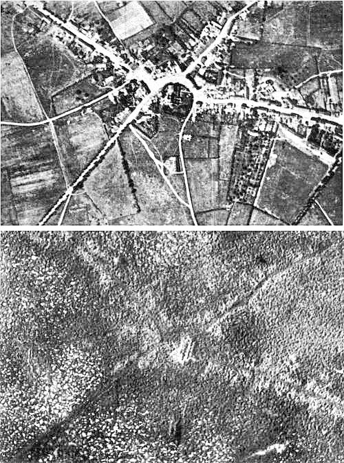
English: Aerial view of the village of Passchendaele (north is to the right of the photo) before and after the Third Battle of Ypres, 1917.
Français : Vue aerienne du village de Passendale, avant et après la troisième bataille d'Ypres, en 1917. Le nord est à droite sur les photos. |
|||
| তারিখ | ||||
| উৎস |
|
|||
| লেখক | Photographer not identified. "Official photograph". | |||
| অনুমতি (এ ফাইলের পুনঃব্যবহার) |
|
|||
| অন্যান্য সংস্করণ |
|


| ক্যামেরার অবস্থান | | এটি এবং অন্যান্য ছবি তাদের অবস্থানের উপর: ওপেনস্ট্রিটম্যাপ |
|---|
ফাইলের ইতিহাস
যেকোনো তারিখ/সময়ে ক্লিক করে দেখুন ফাইলটি তখন কী অবস্থায় ছিল।
| তারিখ/সময় | সংক্ষেপচিত্র | মাত্রা | ব্যবহারকারী | মন্তব্য | |
|---|---|---|---|---|---|
| বর্তমান | ১৭:৩৩, ২২ ডিসেম্বর ২০১১ | | ৫০০ × ৬৭৪ (৩১৭ কিলোবাইট) | Soerfm | Sharpness |
| ১১:২৩, ২৫ এপ্রিল ২০০৫ |  | ৫০০ × ৬৭৪ (২৯০ কিলোবাইট) | Gsl~commonswiki | Second version: Lightened and set levels. Sharpened slightly (by w:User:Ian Dunster) | |
| ১১:২১, ২৫ এপ্রিল ২০০৫ |  | ৫০০ × ৬৭৪ (৮১ কিলোবাইট) | Gsl~commonswiki | Original version from en.wikipedia.org |
সংযোগসমূহ
নিচের পৃষ্ঠা(গুলো) থেকে এই ছবিতে সংযোগ আছে:
ফাইলের বৈশ্বিক ব্যবহার
নিচের অন্যান্য উইকিগুলো এই ফাইলটি ব্যবহার করে:
- ar.wikipedia.org-এ ব্যবহার
- ast.wikipedia.org-এ ব্যবহার
- az.wikipedia.org-এ ব্যবহার
- bg.wikipedia.org-এ ব্যবহার
- br.wikipedia.org-এ ব্যবহার
- ca.wikipedia.org-এ ব্যবহার
- cs.wikipedia.org-এ ব্যবহার
- da.wikipedia.org-এ ব্যবহার
- de.wikipedia.org-এ ব্যবহার
- el.wikipedia.org-এ ব্যবহার
- en.wikipedia.org-এ ব্যবহার
- Battle of Passchendaele
- Wikipedia:Featured picture candidates/October-2004
- Wikipedia:Picture of the day/November 2004
- Wikipedia:Picture of the day/November 7, 2004
- Wikipedia:POTD/November 7, 2004
- Alexander Edwards
- Wikipedia:Picture of the day/February 2005
- Wikipedia:POTD/February 21, 2005
- Wikipedia:Picture of the day/February 21, 2005
- Wikipedia:Picture of the day/December 2005
- Wikipedia:Picture of the day/December 21, 2005
- Wikipedia:POTD/December 21, 2005
- User:Cyde/Featured pictures
- Passendale
- Portal:United Kingdom/Featured picture/12
- Portal:United Kingdom/Featured picture
- Second Battle of Passchendaele
- Wikipedia:Featured picture candidates/delist/2008
- Wikipedia:Featured picture candidates/delist/Village of Passchendaele
- User talk:Durova/Archive 61
- Wikipedia:Featured picture candidates/delist/2009
- Wikipedia:Featured picture candidates/delist/File:Passchendaele aerial view.jpg
- User:Durova/FPC survey
- Wikipedia talk:Valued picture candidates/Archive 3
- Wikipedia:Featured picture candidates/delist/2015
- Wikipedia:Featured picture candidates/delist/Passchendaele
- Night action of 1/2 December 1917
- es.wikipedia.org-এ ব্যবহার
- fi.wikipedia.org-এ ব্যবহার
- fr.wikipedia.org-এ ব্যবহার
- fy.wikipedia.org-এ ব্যবহার
- gl.wikipedia.org-এ ব্যবহার
- he.wikipedia.org-এ ব্যবহার
- hr.wikipedia.org-এ ব্যবহার
এই ফাইলের অন্যান্য বৈশ্বিক ব্যবহার দেখুন।