চিত্র:PanAmericanHwy.png

এই প্রাকদর্শনের আকার: ৪৩৪ × ৫৯৯ পিক্সেল। অন্যান্য আকারসমূহ: ১৭৪ × ২৪০ পিক্সেল | ৩৪৮ × ৪৮০ পিক্সেল | ৫৫৬ × ৭৬৮ পিক্সেল | ৭৪২ × ১,০২৪ পিক্সেল | ১,৬০০ × ২,২০৮ পিক্সেল।
পূর্ণ রেজোলিউশন (১,৬০০ × ২,২০৮ পিক্সেল, ফাইলের আকার: ২.০৮ মেগাবাইট, এমআইএমই ধরন: image/png)
| এই ফাইলটি উইকিমিডিয়া কমন্স থেকে নেওয়া। সেখানের বর্ণনা পাতার বিস্তারিত নিম্নে দেখানো হলো। (সম্পাদনা)
|

|
This road map image could be re-created using vector graphics as an SVG file. This has several advantages; see Commons:Media for cleanup for more information. If an SVG form of this image is available, please upload it and afterwards replace this template with
{{vector version available|new image name}}.
It is recommended to name the SVG file “PanAmericanHwy.svg”—then the template Vector version available (or Vva) does not need the new image name parameter. |
সারাংশ
| বিবরণ |
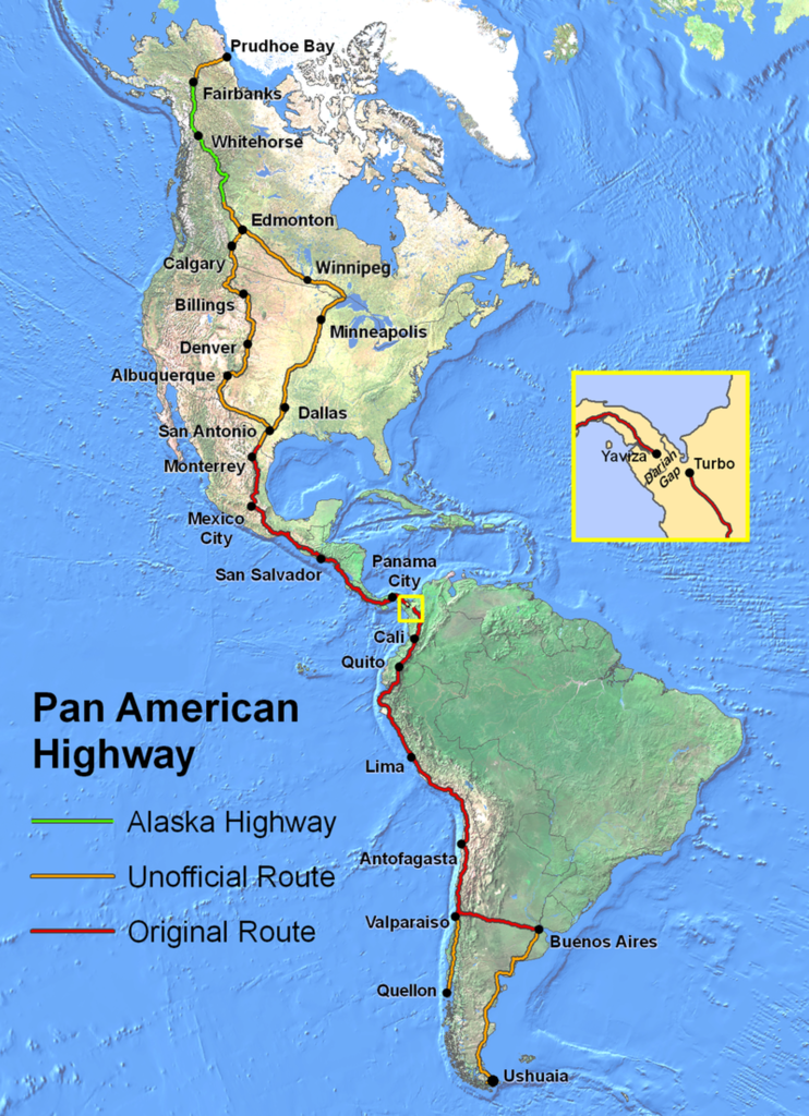
English: Route of the Pan-American Highway. Includes original route and unofficial extensions but doesn't reflect official designation of U.S. interstate highway system. Hotine Oblique Mercator Two Point Natural Origin Projection. |
| উৎস | নিজের কাজ |
| লেখক | Created by en:User:Seaweege and released to PD |
লাইসেন্স প্রদান

|
The copyright holder of this work allows anyone to use it for any purpose including unrestricted redistribution, commercial use, and modification.
Usage notes:
|
ফাইলের ইতিহাস
যেকোনো তারিখ/সময়ে ক্লিক করে দেখুন ফাইলটি তখন কী অবস্থায় ছিল।
| তারিখ/সময় | সংক্ষেপচিত্র | মাত্রা | ব্যবহারকারী | মন্তব্য | |
|---|---|---|---|---|---|
| বর্তমান | ০২:৩২, ১৮ জানুয়ারি ২০২২ | | ১,৬০০ × ২,২০৮ (২.০৮ মেগাবাইট) | Natewich | Route of the Pan American Highway. Includes original route and unofficial extensions. Hotine Oblique Mercator Two Point Natural Origin Projection. Taken from en:Image:PanAmericanHwy.png. |
| ০১:৩৩, ২৭ নভেম্বর ২০০৭ |  | ১,৩২৫ × ১,৮২৮ (৩.৭২ মেগাবাইট) | Jabul | Route of the Pan American Highway. Includes original route and unofficial extensions. Hotine Oblique Mercator Two Point Natural Origin Projection. Taken from en:Image:PanAmericanHwy.png. | |
| ০১:১৮, ২৭ নভেম্বর ২০০৭ |  | ১,৩২৫ × ১,৮২৮ (৩.৭২ মেগাবাইট) | Jabul | ||
| ০২:৩৬, ১৭ জুন ২০০৭ |  | ১,৩২৫ × ১,৮২৮ (৩.৬ মেগাবাইট) | SchuminWeb | {{Information |Description=Route of the Pan American Highway. Includes original route and unofficial extensions. Hotine Oblique Mercator Two Point Natural Origin Projection |Source=Originally from [http://en.wikipedia.org en.wikipedia]; description page | |
| ১৫:২৬, ২৯ ডিসেম্বর ২০০৬ |  | ১,৭০০ × ২,২০০ (৩.৬২ মেগাবাইট) | Chigliak | Original Description: Route of the Pan American Highway. Includes original route and unofficial extensions. Hotine Oblique Mercator Two Point Natural Origin Projection. Taken from en:Image:PanAmericanHwy.png. Created by en:User:Seaweege and rea |
সংযোগসমূহ
নিচের পৃষ্ঠা(গুলো) থেকে এই ছবিতে সংযোগ আছে:
ফাইলের বৈশ্বিক ব্যবহার
নিচের অন্যান্য উইকিগুলো এই ফাইলটি ব্যবহার করে:
- ar.wikipedia.org-এ ব্যবহার
- be-tarask.wikipedia.org-এ ব্যবহার
- be.wikipedia.org-এ ব্যবহার
- bg.wikipedia.org-এ ব্যবহার
- cs.wikipedia.org-এ ব্যবহার
- de.wikipedia.org-এ ব্যবহার
- de.wikivoyage.org-এ ব্যবহার
- el.wikipedia.org-এ ব্যবহার
- en.wikipedia.org-এ ব্যবহার
- en.wikivoyage.org-এ ব্যবহার
- eo.wikipedia.org-এ ব্যবহার
- et.wikipedia.org-এ ব্যবহার
- eu.wikipedia.org-এ ব্যবহার
- fa.wikipedia.org-এ ব্যবহার
- fi.wikipedia.org-এ ব্যবহার
- fr.wikipedia.org-এ ব্যবহার
- he.wikipedia.org-এ ব্যবহার
- hi.wikibooks.org-এ ব্যবহার
- id.wikipedia.org-এ ব্যবহার
- it.wikipedia.org-এ ব্যবহার
- ja.wikipedia.org-এ ব্যবহার
- ka.wikipedia.org-এ ব্যবহার
- km.wikipedia.org-এ ব্যবহার
- ko.wikipedia.org-এ ব্যবহার
- lt.wikipedia.org-এ ব্যবহার
- ml.wikipedia.org-এ ব্যবহার
- mr.wikipedia.org-এ ব্যবহার
- ms.wikipedia.org-এ ব্যবহার
- nl.wikipedia.org-এ ব্যবহার
- no.wikipedia.org-এ ব্যবহার
এই ফাইলের অন্যান্য বৈশ্বিক ব্যবহার দেখুন।