চিত্র:PIA16064-Mars Curiosity Rover Treasure Map.jpg

পূর্ণ রেজোলিউশন (৩,৩০০ × ২,৫৫০ পিক্সেল, ফাইলের আকার: ১.৬৩ মেগাবাইট, এমআইএমই ধরন: image/jpeg)
| এই ফাইলটি উইকিমিডিয়া কমন্স থেকে নেওয়া। সেখানের বর্ণনা পাতার বিস্তারিত নিম্নে দেখানো হলো। (সম্পাদনা)
|
সারাংশ
| বিবরণ |
English: 08.17.2012
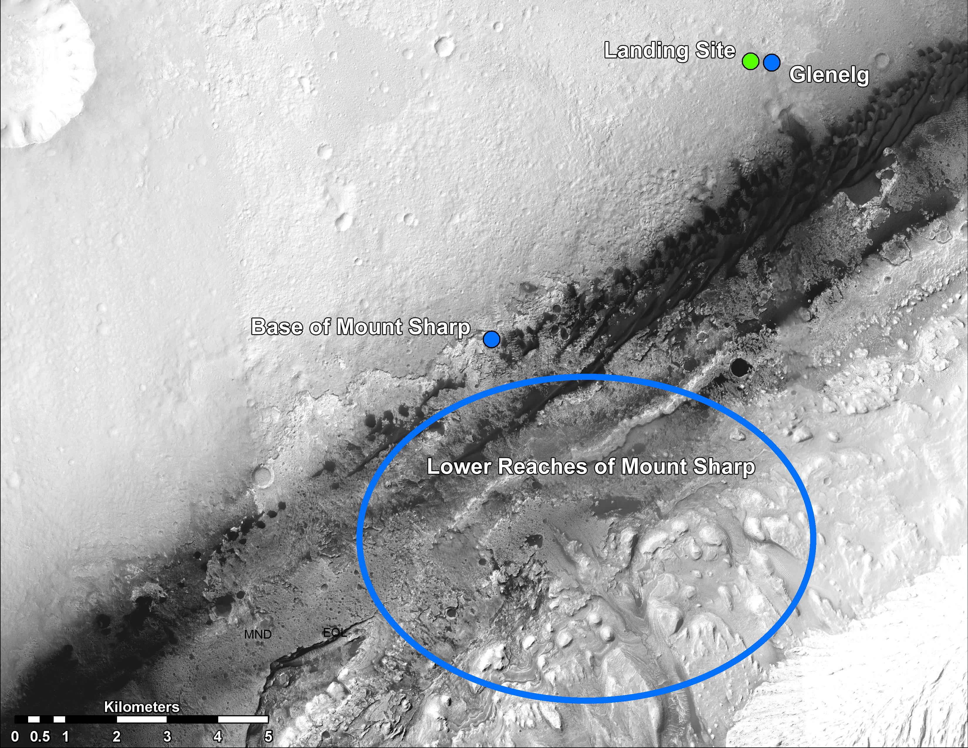
Martian Treasure Map This image shows the landing site of NASA's Curiosity rover and destinations scientists want to investigate. Curiosity landed inside Gale Crater on Mars on Aug. 5 PDT (Aug. 6 EDT) at the green dot, within the Yellowknife quadrangle. The team has chosen for it to move toward the region marked by a blue dot that is nicknamed Glenelg. That area marks the intersection of three kinds of terrain. The science team thought the name Glenelg was appropriate because, if Curiosity traveled there, it would visit it twice -- both coming and going -- and the word Glenelg is a palindrome. Then, the rover will aim to drive to the blue spot marked "Base of Mt. Sharp", which is a natural break in the dunes that will allow Curiosity to begin scaling the lower reaches of Mount Sharp. At the base of Mt. Sharp are layered buttes and mesas that scientists hope will reveal the area's geological history. These annotations have been made on top of an image acquired by the High Resolution Imaging Science Experiment (HiRISE) camera on NASA's Mars Reconnaissance Orbiter. Polski: Trasa przemarszu łazika Curiosity pokazuje lądowisko i docelowe miejsca badań naukowców NASA . Curiosity wylądował wewnątrz krateru Gale (Bradbury Landing) 5 sierpnia PDT (06 sierpnia EDT) w miejscu oznaczonym zieloną kropką, w czworoboku Yellowknife. Zespół postanowił , aby poruszać się w kierunku regionu oznaczonego niebieską kropką, jest nazywanego Glenelg. Obszar ten wyznacza punkt przecięcia trzech rodzajach terenu. Naukowy zespół uznał, że nazwa Glenelg była właściwa, ponieważ Curiosity podczas podróży odwiedziłby to miejsce dwa razy - zarówno przychodząc jak i odchodząc, a słowo Glenelg jest palindromem. Następnie, łazik będzie poruszać się do miejsca oznaczonego niebieskim owalem "Baza Mt. Sharpa", która jest naturalną przerwą w wydmach, które pozwolą rozpocząć poruszanie się łazika w kierunku dolnego odcinka Mount Sharp (Aeolis Mona). U podnóża Mount Sharp są wzgórza warstwowe i płaskowyże, tak że naukowcy mają nadzieję ujawnić historię geologiczną tego obszaru.
Image Credit: NASA/JPL-Caltech/Univ. of Arizona |
| তারিখ | |
| উৎস | http://photojournal.jpl.nasa.gov/jpeg/PIA16064.jpg |
| লেখক | NASA/JPL-Caltech/Univ. of Arizona |
| অন্যান্য সংস্করণ | http://photojournal.jpl.nasa.gov/catalog/PIA16064 |
লাইসেন্স প্রদান
| এই ফাইলটি পাবলিক ডোমেইনে আছে কারণ এটি শুধুমাত্র নাসা কর্তৃক নির্মিত হয়েছিল। নাসার কপিরাইট নীতি হচ্ছে যে "নাসা কর্তৃক উল্লেখ না থাকলে নাসার উপাদান কপিরাইট দ্বারা সুরক্ষিত নয়"। (Template:PD-USGov, নাসার কপিরাইট নীতির পাতা অথবা জেপিএল চিত্র ব্যবহারের নীতি দেখুন।) | ||
 |
সতর্কবার্তা:
|
| Annotations | This image is annotated: View the annotations at Commons |
ফাইলের ইতিহাস
যেকোনো তারিখ/সময়ে ক্লিক করে দেখুন ফাইলটি তখন কী অবস্থায় ছিল।
| তারিখ/সময় | সংক্ষেপচিত্র | মাত্রা | ব্যবহারকারী | মন্তব্য | |
|---|---|---|---|---|---|
| বর্তমান | ২১:৪৫, ২১ আগস্ট ২০১২ | | ৩,৩০০ × ২,৫৫০ (১.৬৩ মেগাবাইট) | Drbogdan |
সংযোগসমূহ
নিচের পৃষ্ঠা(গুলো) থেকে এই ছবিতে সংযোগ আছে:
ফাইলের বৈশ্বিক ব্যবহার
নিচের অন্যান্য উইকিগুলো এই ফাইলটি ব্যবহার করে:
- ca.wikipedia.org-এ ব্যবহার
- en.wikipedia.org-এ ব্যবহার
- es.wikipedia.org-এ ব্যবহার
- fa.wikipedia.org-এ ব্যবহার
- fr.wikipedia.org-এ ব্যবহার
- it.wikipedia.org-এ ব্যবহার
- ja.wikipedia.org-এ ব্যবহার
- ko.wikipedia.org-এ ব্যবহার
- pl.wikipedia.org-এ ব্যবহার
- ru.wikipedia.org-এ ব্যবহার
- sr.wikipedia.org-এ ব্যবহার
- test.wikipedia.org-এ ব্যবহার
- tr.wikipedia.org-এ ব্যবহার
- uk.wikipedia.org-এ ব্যবহার
- zh.wikipedia.org-এ ব্যবহার