চিত্র:Oceanias Regions.png
এর চেয়ে বেশি রেজোলিউশন লভ্য নয়।
Oceanias_Regions.png (৫৫২ × ৩৫০ পিক্সেল, ফাইলের আকার: ২০ কিলোবাইট, এমআইএমই ধরন: image/png)
| এই ফাইলটি উইকিমিডিয়া কমন্স থেকে নেওয়া। সেখানের বর্ণনা পাতার বিস্তারিত নিম্নে দেখানো হলো। (সম্পাদনা)
|

|
This locator map image could be re-created using vector graphics as an SVG file. This has several advantages; see Commons:Media for cleanup for more information. If an SVG form of this image is available, please upload it and afterwards replace this template with
{{vector version available|new image name}}.
It is recommended to name the SVG file “Oceanias Regions.svg”—then the template Vector version available (or Vva) does not need the new image name parameter. |
| বিবরণ |
Català: Regions d'Oceania.
Čeština: Regiony Oceánie.
Deutsch: Regionen Ozeaniens.
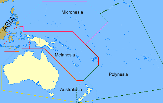
English: Regions of Oceania. Regions of Oceania: In its narrow usage Oceania refers to Polynesia (including New Zealand), Melanesia (including New Guinea) and Micronesia. In wider usage it includes Australia. It may also include the Malay archipelago. In uncommon usage it includes islands such as Japan and the Aleutian Islands.
Limburgs: Regio's van Oceanië.
Русский: Регионы Океании.
Саха тыла: Океания регионнара.
Svenska: Oceaniens regioner.
తెలుగు: ఓషియానియా ప్రాంతాలు.
Tiếng Việt: Các khu vực của châu Đại Dương. |
| তারিখ | ১৭ ফেব্রুয়ারি ২০০৮ (মূল আপলোডের তারিখ) |
| উৎস | en.wikipedia থেকে কমন্সে স্থানান্তরিত করা হয়েছে Grillo কর্তৃক CommonsHelper ব্যবহার করে। |
| লেখক | ইংরেজি উইকিপিডিয়া-এর ASDFGH |
লাইসেন্স প্রদান
| এই কাজের প্রণেতা ইংরেজি উইকিপিডিয়া-এর ASDFGH কাজটি পাবলিক ডোমেইনে প্রকাশ করেছেন। এটি বিশ্বব্যাপী প্রযোজ্য হবে। কিছু দেশে এটি আইনত সিদ্ধ নাও হতে পারে, যদি তাই হয়: ASDFGH যে-কাউকে যেকোনো উদ্দেশ্যে, বিনাশর্তে এই কাজটি ব্যবহারের অনুমতি প্রদান করেন, যদি না সেই শর্তগুলো আইনত প্রয়োজনীয় হয়। |
মূল আপলোড লগ
মূল বিবরণ পাতাটি এখানে ছিল। নিম্নলিখিত সকল ব্যবহারকারীর নাম en.wikipedia-এ উল্লেখ করা ছিল।
- 2008-02-17 00:28 ASDFGH 552×350× (17433 bytes)
ফাইলের ইতিহাস
যেকোনো তারিখ/সময়ে ক্লিক করে দেখুন ফাইলটি তখন কী অবস্থায় ছিল।
| তারিখ/সময় | সংক্ষেপচিত্র | মাত্রা | ব্যবহারকারী | মন্তব্য | |
|---|---|---|---|---|---|
| বর্তমান | ১৩:২০, ১৮ সেপ্টেম্বর ২০১১ | | ৫৫২ × ৩৫০ (২০ কিলোবাইট) | Maphobbyist | Map depicting continents according to plate tectonics. The Eastern Sunda Islands and the Moluccas are also part of the Asian tectonic plate. |
| ১৬:৫৭, ৩০ অক্টোবর ২০০৮ |  | ৫৫২ × ৩৫০ (১৭ কিলোবাইট) | File Upload Bot (Magnus Manske) | {{BotMoveToCommons|en.wikipedia}} {{Information |Description={{en|''no original description''}} |Source=Transferred from [http://en.wikipedia.org en.wikipedia]; transferred to Commons by User:Grillo using [http://tools.wikimedia.de/~magnus/commonshel |
সংযোগসমূহ
নিচের পৃষ্ঠা(গুলো) থেকে এই ছবিতে সংযোগ আছে:
ফাইলের বৈশ্বিক ব্যবহার
নিচের অন্যান্য উইকিগুলো এই ফাইলটি ব্যবহার করে:
- ast.wiktionary.org-এ ব্যবহার
- ca.wikipedia.org-এ ব্যবহার
- co.wikipedia.org-এ ব্যবহার
- cs.wikipedia.org-এ ব্যবহার
- cy.wiktionary.org-এ ব্যবহার
- da.wiktionary.org-এ ব্যবহার
- el.wiktionary.org-এ ব্যবহার
- en.wikipedia.org-এ ব্যবহার
- en.wiktionary.org-এ ব্যবহার
- fa.wikipedia.org-এ ব্যবহার
- fo.wikipedia.org-এ ব্যবহার
- fr.wikipedia.org-এ ব্যবহার
- gl.wikipedia.org-এ ব্যবহার
- hi.wikipedia.org-এ ব্যবহার
- ilo.wikipedia.org-এ ব্যবহার
- incubator.wikimedia.org-এ ব্যবহার
- ja.wikipedia.org-এ ব্যবহার
- kk.wikipedia.org-এ ব্যবহার
- ko.wikipedia.org-এ ব্যবহার
- la.wikipedia.org-এ ব্যবহার
- li.wikipedia.org-এ ব্যবহার
- lld.wikipedia.org-এ ব্যবহার
- lt.wikipedia.org-এ ব্যবহার
- mg.wikipedia.org-এ ব্যবহার
- my.wikipedia.org-এ ব্যবহার
- pa.wikipedia.org-এ ব্যবহার
- pnb.wikipedia.org-এ ব্যবহার
- ro.wikipedia.org-এ ব্যবহার
- sah.wikipedia.org-এ ব্যবহার
- si.wiktionary.org-এ ব্যবহার
- sk.wikipedia.org-এ ব্যবহার
- sv.wikipedia.org-এ ব্যবহার
- ta.wikipedia.org-এ ব্যবহার
- te.wikipedia.org-এ ব্যবহার
- th.wikipedia.org-এ ব্যবহার
- tr.wikipedia.org-এ ব্যবহার
- uk.wikipedia.org-এ ব্যবহার
- yo.wikipedia.org-এ ব্যবহার