চিত্র:Occupied Palestinian Territories.jpg

এই প্রাকদর্শনের আকার: ৩৯৩ × ৫৯৯ পিক্সেল। অন্যান্য আকারসমূহ: ১৫৭ × ২৪০ পিক্সেল | ৩১৫ × ৪৮০ পিক্সেল | ৫০৪ × ৭৬৮ পিক্সেল | ৬৭২ × ১,০২৪ পিক্সেল | ১,৮৯৫ × ২,৮৮৯ পিক্সেল।
পূর্ণ রেজোলিউশন (১,৮৯৫ × ২,৮৮৯ পিক্সেল, ফাইলের আকার: ৯৪৯ কিলোবাইট, এমআইএমই ধরন: image/jpeg)
| এই ফাইলটি উইকিমিডিয়া কমন্স থেকে নেওয়া। সেখানের বর্ণনা পাতার বিস্তারিত নিম্নে দেখানো হলো। (সম্পাদনা)
|
সারাংশ
| বিবরণ |
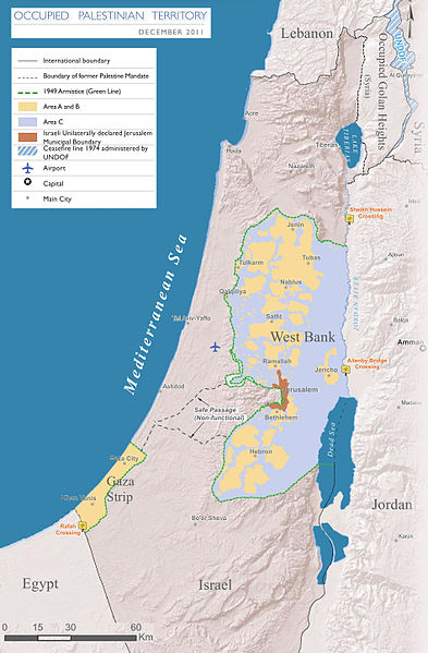
English: Map of the Occupied Palestinian Territories (West Bank and Gaza Strip), marked by the Green Line. Based on Reference Map: occupied Palestinian territory: Overview Map, as of December 2011. Published by United Nations Office for the Coordination of Humanitarian Affairs (OCHAoPt), 25 January 2012
العربية: خريطة للأراضي الفلسطينية المحتلة (الضفة الغربية وقطاع غزة) ، مميزة بالخط الأخضر. استنادًا إلى الخريطة المرجعية: "الأراضي الفلسطينية المحتلة: خريطة عامة" ، اعتبارًا من ديسمبر 2011. تم النشر بواسطة مكتب الأمم المتحدة لتنسيق الشؤون الإنسانية (OCHAoPt ) ، 25 يناير 2012 |
| তারিখ | |
| উৎস | নিজের কাজ, based on http://www.ochaopt.org/documents/ochaopt_atlas_opt_general_december2011.pdf on [1] |
| লেখক | Wickey-nl |

|
This map image could be re-created using vector graphics as an SVG file. This has several advantages; see Commons:Media for cleanup for more information. If an SVG form of this image is available, please upload it and afterwards replace this template with
{{vector version available|new image name}}.
It is recommended to name the SVG file “Occupied Palestinian Territories.svg”—then the template Vector version available (or Vva) does not need the new image name parameter. |


|
এই ফাইল-এর হালনাগাদ প্রয়োজন কারণ: This indicates occupation in 2011, more than a decade ago -- far too old in this dynamic and contested region এটি করার সময় আপনি ফাইল-এ একটি সময়সীমা যোগ করতে পারেন।
|
লাইসেন্স প্রদান
আমি, এই কাজের স্বত্বাধিকারী, এতদ্দ্বারা আমি এই কাজকে নিম্ন বর্ণিত লাইসেন্সের আওতায় প্রকাশ করলাম:
এই ফাইলটি ক্রিয়েটিভ কমন্স অ্যাট্রিবিউশন-শেয়ার অ্যালাইক ৩.০ আনপোর্টেড লাইসেন্সের আওতায় লাইসেন্সকৃত।
- আপনি স্বাধীনভাবে:
- বণ্টন করতে পারেন – এ কাজটি অনুলিপি, বিতরণ এবং প্রেরণ করতে পারেন
- পুনঃমিশ্রণ করতে পারেন – কাজটি অভিযোজন করতে পারেন
- নিম্নের শর্তাবলীর ভিত্তিতে:
- স্বীকৃতিপ্রদান – আপনাকে অবশ্যই যথাযথ স্বীকৃতি প্রদান করতে হবে, লাইসেন্সের একটি লিঙ্ক সরবরাহ করতে হবে এবং কোনো পরিবর্তন হয়েছে কিনা তা নির্দেশ করতে হবে। আপনি যেকোনো যুক্তিসঙ্গত পদ্ধতিতে এটি করতে পারেন। কিন্তু এমন ভাবে নয়, যাতে প্রকাশ পায় যে লাইসেন্সধারী আপনাকে বা আপনার এই ব্যবহারের জন্য অনুমোদন দিয়েছে।
- একইভাবে বণ্টন – আপনি যদি কাজটি পুনঃমিশ্রণ, রুপান্তর, বা এর ওপর ভিত্তি করে নতুন সৃষ্টিকর্ম তৈরি করেন, তবে আপনাকে অবশ্যই আপনার অবদান একই লাইসেন্স বা একই রকমের লাইসেন্সের আওতায় বিতরণ করতে হবে।

ফাইলের ইতিহাস
যেকোনো তারিখ/সময়ে ক্লিক করে দেখুন ফাইলটি তখন কী অবস্থায় ছিল।
| তারিখ/সময় | সংক্ষেপচিত্র | মাত্রা | ব্যবহারকারী | মন্তব্য | |
|---|---|---|---|---|---|
| বর্তমান | ১৭:০৮, ২৫ মার্চ ২০১৪ | | ১,৮৯৫ × ২,৮৮৯ (৯৪৯ কিলোবাইট) | Wickey-nl | User created page with UploadWizard |
সংযোগসমূহ
নিচের পৃষ্ঠা(গুলো) থেকে এই ছবিতে সংযোগ আছে:
ফাইলের বৈশ্বিক ব্যবহার
নিচের অন্যান্য উইকিগুলো এই ফাইলটি ব্যবহার করে:
- af.wikipedia.org-এ ব্যবহার
- ar.wikipedia.org-এ ব্যবহার
- az.wikipedia.org-এ ব্যবহার
- bh.wikipedia.org-এ ব্যবহার
- bug.wikipedia.org-এ ব্যবহার
- cs.wikipedia.org-এ ব্যবহার
- da.wikipedia.org-এ ব্যবহার
- de.wikipedia.org-এ ব্যবহার
- el.wikipedia.org-এ ব্যবহার
- en.wikipedia.org-এ ব্যবহার
- Israeli–Palestinian conflict
- Palestinian territories
- Israeli-occupied territories
- Frozen conflict
- United Nations Security Council Resolution 1515
- Talk:Israeli–Palestinian conflict/Archive 18
- United States involvement in regime change
- Boycott, Divestment and Sanctions
- Two-state solution
- Talk:State of Palestine/Archive 12
- Freedom of religion in Asia by country
- User:Falcaorib
- From the river to the sea
- User:Christophervincent01
- es.wikipedia.org-এ ব্যবহার
- et.wikipedia.org-এ ব্যবহার
- fa.wikipedia.org-এ ব্যবহার
- fi.wikipedia.org-এ ব্যবহার
- fy.wikipedia.org-এ ব্যবহার
- gl.wikipedia.org-এ ব্যবহার
- he.wikipedia.org-এ ব্যবহার
- hu.wikipedia.org-এ ব্যবহার
- id.wikipedia.org-এ ব্যবহার
- io.wikipedia.org-এ ব্যবহার
- it.wikipedia.org-এ ব্যবহার
- ja.wikipedia.org-এ ব্যবহার
- la.wikipedia.org-এ ব্যবহার
- lt.wikipedia.org-এ ব্যবহার
- min.wikipedia.org-এ ব্যবহার
- ml.wikipedia.org-এ ব্যবহার
এই ফাইলের অন্যান্য বৈশ্বিক ব্যবহার দেখুন।