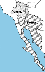
চিত্র:Mojave-sonoran deserts.png

এই প্রাকদর্শনের আকার: ৩৭৯ × ৬০০ পিক্সেল। অন্যান্য আকারসমূহ: ১৫১ × ২৪০ পিক্সেল | ৬৩২ × ১,০০০ পিক্সেল।
পূর্ণ রেজোলিউশন (৬৩২ × ১,০০০ পিক্সেল, ফাইলের আকার: ৩০৯ কিলোবাইট, এমআইএমই ধরন: image/png)
| এই ফাইলটি উইকিমিডিয়া কমন্স থেকে নেওয়া। সেখানের বর্ণনা পাতার বিস্তারিত নিম্নে দেখানো হলো। (সম্পাদনা)
|
সারাংশ

|
This locator map image could be re-created using vector graphics as an SVG file. This has several advantages; see Commons:Media for cleanup for more information. If an SVG form of this image is available, please upload it and afterwards replace this template with
{{vector version available|new image name}}.
It is recommended to name the SVG file “Mojave-sonoran deserts.svg”—then the template Vector version available (or Vva) does not need the new image name parameter. |
| বিবরণ | |
| তারিখ | ২৮ মার্চ ২০০৭ (মূল আপলোডের তারিখ) |
| উৎস | Archived source link |
| লেখক | USGS |
| অন্যান্য সংস্করণ |

লাইসেন্স প্রদান
This image is in the public domain in the United States because it only contains materials that originally came from the United States Geological Survey, an agency of the United States Department of the Interior. For more information, see the official USGS copyright policy.
|
মূল আপলোড লগ
মূল বিবরণ পাতাটি এখানে ছিল। নিম্নলিখিত সকল ব্যবহারকারীর নাম en.wikipedia-এ উল্লেখ করা ছিল।
- 2010-08-06 19:21 TimVickers 223×343× (58420 bytes) try again
- 2010-08-06 19:20 TimVickers 223×343× (69557 bytes) Colored in ocean so you can see where land and ocean are at a glance
- 2007-03-28 03:27 Rsduhamel 223×343× (69557 bytes) From: [http://wwwpaztcn.wr.usgs.gov/rsch_highlight/articles/200508.html http://wwwpaztcn.wr.usgs.gov/rsch_highlight/articles/200508.html]
ফাইলের ইতিহাস
যেকোনো তারিখ/সময়ে ক্লিক করে দেখুন ফাইলটি তখন কী অবস্থায় ছিল।
| তারিখ/সময় | সংক্ষেপচিত্র | মাত্রা | ব্যবহারকারী | মন্তব্য | |
|---|---|---|---|---|---|
| বর্তমান | ২৩:৩১, ৩০ ডিসেম্বর ২০১৫ | | ৬৩২ × ১,০০০ (৩০৯ কিলোবাইট) | WikiKiwi | oops, typo |
| ২৩:২৮, ৩০ ডিসেম্বর ২০১৫ |  | ৬৩২ × ১,০০০ (৩০৯ কিলোবাইট) | WikiKiwi | Higher quality, better font | |
| ২২:৩৪, ৭ নভেম্বর ২০১০ |  | ২২৩ × ৩৪৩ (৫৭ কিলোবাইট) | File Upload Bot (Magnus Manske) | {{BotMoveToCommons|en.wikipedia|year={{subst:CURRENTYEAR}}|month={{subst:CURRENTMONTHNAME}}|day={{subst:CURRENTDAY}}}} {{Information |Description={{en|From: [http://wwwpaztcn.wr.usgs.gov/rsch_highlight/articles/200508.html http://wwwpaztcn.wr.usgs.gov/rs |
সংযোগসমূহ
নিচের পৃষ্ঠা(গুলো) থেকে এই ছবিতে সংযোগ আছে:
ফাইলের বৈশ্বিক ব্যবহার
নিচের অন্যান্য উইকিগুলো এই ফাইলটি ব্যবহার করে:
- ar.wikipedia.org-এ ব্যবহার
- az.wikipedia.org-এ ব্যবহার
- bg.wikipedia.org-এ ব্যবহার
- bs.wikipedia.org-এ ব্যবহার
- ckb.wikipedia.org-এ ব্যবহার
- de.wikipedia.org-এ ব্যবহার
- et.wikipedia.org-এ ব্যবহার
- fa.wikipedia.org-এ ব্যবহার
- fi.wikipedia.org-এ ব্যবহার
- hu.wikipedia.org-এ ব্যবহার
- it.wikipedia.org-এ ব্যবহার
- ka.wikipedia.org-এ ব্যবহার
- kk.wikipedia.org-এ ব্যবহার
- kn.wikipedia.org-এ ব্যবহার
- ko.wikipedia.org-এ ব্যবহার
- lfn.wikipedia.org-এ ব্যবহার
- lt.wikipedia.org-এ ব্যবহার
- mk.wikipedia.org-এ ব্যবহার
- ml.wikipedia.org-এ ব্যবহার
- mr.wikipedia.org-এ ব্যবহার
- pa.wikipedia.org-এ ব্যবহার
- pnb.wikipedia.org-এ ব্যবহার
- ro.wikipedia.org-এ ব্যবহার
- ru.wikipedia.org-এ ব্যবহার
- sq.wikipedia.org-এ ব্যবহার
- ta.wikipedia.org-এ ব্যবহার
- tr.wikipedia.org-এ ব্যবহার
- vi.wikipedia.org-এ ব্যবহার
- www.wikidata.org-এ ব্যবহার
- yo.wikipedia.org-এ ব্যবহার
- zh.wikipedia.org-এ ব্যবহার