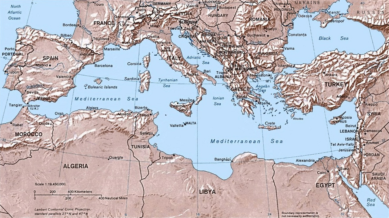
চিত্র:Mediterranean Relief.jpg
এই প্রাকদর্শনের আকার: ৮০০ × ৪৪৮ পিক্সেল। অন্যান্য আকারসমূহ: ৩২০ × ১৭৯ পিক্সেল | ৬৪০ × ৩৫৯ পিক্সেল | ১,৩০৮ × ৭৩৩ পিক্সেল।
পূর্ণ রেজোলিউশন (১,৩০৮ × ৭৩৩ পিক্সেল, ফাইলের আকার: ৬৩৫ কিলোবাইট, এমআইএমই ধরন: image/jpeg)
| এই ফাইলটি উইকিমিডিয়া কমন্স থেকে নেওয়া। সেখানের বর্ণনা পাতার বিস্তারিত নিম্নে দেখানো হলো। (সম্পাদনা)
|

|
This map image could be re-created using vector graphics as an SVG file. This has several advantages; see Commons:Media for cleanup for more information. If an SVG form of this image is available, please upload it and afterwards replace this template with
{{vector version available|new image name}}.
It is recommended to name the SVG file “Mediterranean Relief.svg”—then the template Vector version available (or Vva) does not need the new image name parameter. |


- Shaded relief Map of the Mediterranean Sea - and its Basin and Landforms.
- The original map was created in 1982 by the Central Intelligence Agency ([1], specifically [2]).
- This version was produced by w:User:Joy, who originally uploaded it to the English Wikipedia:
- 23:46, 28 Sep 2004 . . Joy (343433 bytes) (an update after 22 years :) added borders and names for the ex-yu republics (si,hr,ba,cs,mk); corrected names for de,sk; dropped su name but didn't bother drawing the md/uk/ru borders or names because they're not near the topic at hand, and it's tiresome)
![[2]](http://www.lib.utexas.edu/maps/europe/mediterranean_rel82.jpg)
এই কাজটি মার্কিন যুক্তরাষ্ট্রের পাবলিক ডোমেইনের অন্তর্গত কারণ মার্কিন যুক্তরাষ্ট্রের কোডের শিরোনাম ১৭, পরিচ্ছদ ১, অনুচ্ছেদ ১০৫ শর্তাবলীর অধীনে এটি একটি কাজ যা অফিসিয়াল দায়িত্বের অংশ হিসেবে মার্কিন যুক্তরাষ্ট্র সরকারের কর্মকর্তা বা কর্মচারী দ্বারা প্রস্তুতকৃত । বিস্তারিত জানতে দেখুন কপিরাইট।
টীকা: This only applies to original works of the Federal Government and not to the work of any individual U.S. state, territory, commonwealth, county, municipality, or any other subdivision. This template also does not apply to postage stamp designs published by the United States Postal Service since 1978. (মার্কিন যুক্তরাষ্ট্রে কপিরাইট অফিস চর্চার সারমর্মের § ৩১৩.৬(সি)(১) দেখুন)। এছাড়াও এটি নির্দিষ্ট কয়েকটি মার্কিন ধাতব মুদ্রার জন্য প্রযোজ্য নয়; মার্কিন টাকশালের ব্যবহারের শর্তাবলী দেখুন।
|
 | |
| এই ফাইলটি কপিরাইট আইনের আওতায় জানা সকল বাধানিষেধ মুক্ত বলে চিহ্নিত হয়েছে, যার মধ্যে সম্পর্কিত সকল স্বত্ব ও নেইবারিং সত্ত্ব সংযুক্ত। | ||
ফাইলের ইতিহাস
যেকোনো তারিখ/সময়ে ক্লিক করে দেখুন ফাইলটি তখন কী অবস্থায় ছিল।
| তারিখ/সময় | সংক্ষেপচিত্র | মাত্রা | ব্যবহারকারী | মন্তব্য | |
|---|---|---|---|---|---|
| বর্তমান | ১৪:৩২, ৬ মে ২০১৬ | | ১,৩০৮ × ৭৩৩ (৬৩৫ কিলোবাইট) | Julieta39 | Actualised the borders |
| ২১:৩৮, ৩০ মে ২০১৫ |  | ১,৩০৮ × ৭৩৩ (৬১৪ কিলোবাইট) | Subtropical-man | Reverted to version as of 18:25, 29 August 2011 | |
| ০০:৫৯, ১ সেপ্টেম্বর ২০১১ |  | ১,৪২৮ × ৮০০ (৪০০ কিলোবাইট) | Gwillhickers | Larger image, better sharpness | |
| ০০:৫৮, ১ সেপ্টেম্বর ২০১১ |  | ১,৪২৮ × ৮০০ (৪০০ কিলোবাইট) | Gwillhickers | Larger ima | |
| ১৮:২৫, ২৯ আগস্ট ২০১১ |  | ১,৩০৮ × ৭৩৩ (৬১৪ কিলোবাইট) | Subtropical-man | ||
| ২২:২১, ২৪ আগস্ট ২০১১ |  | ১,৪২৮ × ৮০০ (৪০০ কিলোবাইট) | Gwillhickers | better sharpness, color tone | |
| ০১:০১, ২৭ জুন ২০১০ |  | ১,৩০৮ × ৭৩৩ (৬১৪ কিলোবাইট) | Ras67 | rotated and cropped | |
| ২০:২২, ৪ জুন ২০১০ |  | ১,৩২৫ × ৭৩৯ (২৮৮ কিলোবাইট) | Cropbot | upload cropped version, operated by User:diaa_abdelmoneim. Summary: cropped | |
| ১৯:২২, ২১ ডিসেম্বর ২০০৫ |  | ১,৩৩২ × ৭৯২ (২৭৪ কিলোবাইট) | Lhgodoy~commonswiki | Noise removal in original image | |
| ২০:৫৯, ৪ ডিসেম্বর ২০০৪ |  | ১,৩৩২ × ৭৯২ (৩৩৫ কিলোবাইট) | Alfio | Map of the Mediterranean Sea |
সংযোগসমূহ
এই ফাইল ব্যবহার করে এমন কোনো পাতা নেই।
ফাইলের বৈশ্বিক ব্যবহার
নিচের অন্যান্য উইকিগুলো এই ফাইলটি ব্যবহার করে:
- af.wikipedia.org-এ ব্যবহার
- am.wikipedia.org-এ ব্যবহার
- arc.wikipedia.org-এ ব্যবহার
- ar.wikipedia.org-এ ব্যবহার
- arz.wikipedia.org-এ ব্যবহার
- ast.wikipedia.org-এ ব্যবহার
- as.wikipedia.org-এ ব্যবহার
- az.wikipedia.org-এ ব্যবহার
- az.wiktionary.org-এ ব্যবহার
- be.wikipedia.org-এ ব্যবহার
- bo.wikipedia.org-এ ব্যবহার
- bs.wikipedia.org-এ ব্যবহার
- ca.wikipedia.org-এ ব্যবহার
- ceb.wikipedia.org-এ ব্যবহার
- cv.wikipedia.org-এ ব্যবহার
- cy.wikipedia.org-এ ব্যবহার
- da.wikipedia.org-এ ব্যবহার
- de.wikipedia.org-এ ব্যবহার
- dsb.wikipedia.org-এ ব্যবহার
- dty.wikipedia.org-এ ব্যবহার
- el.wikipedia.org-এ ব্যবহার
- en.wikipedia.org-এ ব্যবহার
- en.wiktionary.org-এ ব্যবহার
- eo.wikipedia.org-এ ব্যবহার
- es.wikipedia.org-এ ব্যবহার
এই ফাইলের অন্যান্য বৈশ্বিক ব্যবহার দেখুন।