চিত্র:Khanate of Karabakh in 1809-1817.JPG

পূর্ণ রেজোলিউশন (৬৬২ × ৬১৬ পিক্সেল, ফাইলের আকার: ৮০ কিলোবাইট, এমআইএমই ধরন: image/jpeg)
| এই ফাইলটি উইকিমিডিয়া কমন্স থেকে নেওয়া। সেখানের বর্ণনা পাতার বিস্তারিত নিম্নে দেখানো হলো। (সম্পাদনা)
|
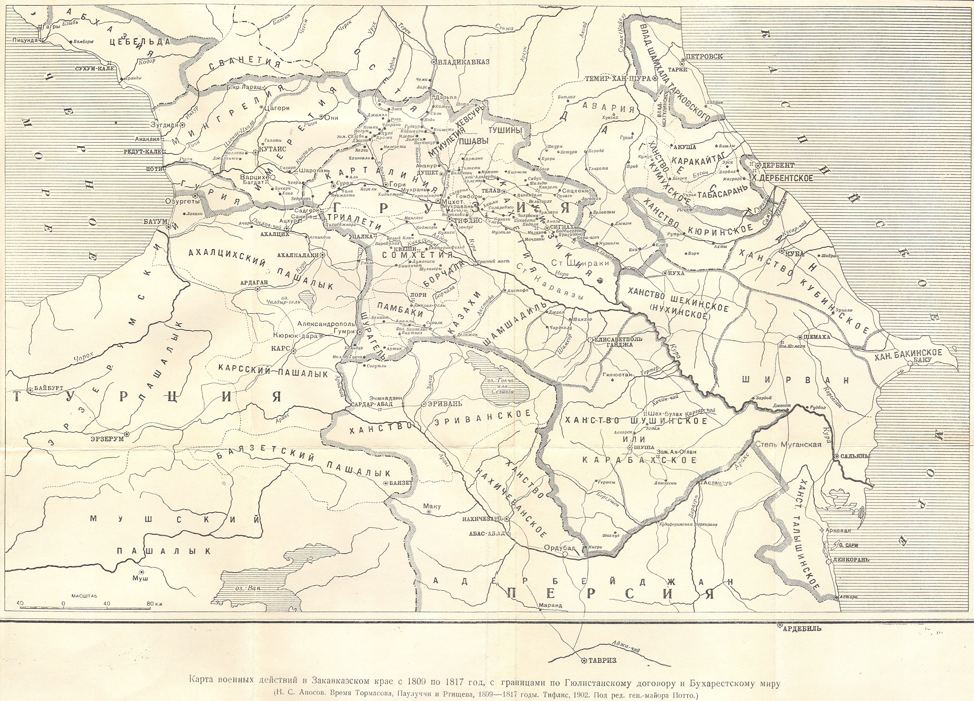
| বিবরণ | Azerbaijani khanate of Karabakh in the map of Caucasus in 1809-1817 years (Карта военных действий в Закавказском крае с 1809 по 1817 год) | ||||
| তারিখ | 1902, Тифлис | ||||
| উৎস |
|
||||
| লেখক | под редакцией ген.-майора Потто. Postwork by Interfase | ||||
| অনুমতি (এ ফাইলের পুনঃব্যবহার) |
|
||||
ফাইলের ইতিহাস
যেকোনো তারিখ/সময়ে ক্লিক করে দেখুন ফাইলটি তখন কী অবস্থায় ছিল।
| তারিখ/সময় | সংক্ষেপচিত্র | মাত্রা | ব্যবহারকারী | মন্তব্য | |
|---|---|---|---|---|---|
| বর্তমান | ০৭:৩০, ২৪ জুন ২০১০ | | ৬৬২ × ৬১৬ (৮০ কিলোবাইট) | Interfase | {{Information |Description=Azerbaijani khanate of Karabakh in the map of Caucasus in 1809-1817 years (Карта военных действий в Закавказском крае с 1809 по 1817 год) |Source=http://www.runivers.ru/images/date/2009 |
সংযোগসমূহ
নিচের পৃষ্ঠা(গুলো) থেকে এই ছবিতে সংযোগ আছে:
ফাইলের বৈশ্বিক ব্যবহার
নিচের অন্যান্য উইকিগুলো এই ফাইলটি ব্যবহার করে:
- azb.wikipedia.org-এ ব্যবহার
- az.wikipedia.org-এ ব্যবহার
- az.wiktionary.org-এ ব্যবহার
- be.wikipedia.org-এ ব্যবহার
- cv.wikipedia.org-এ ব্যবহার
- eo.wikipedia.org-এ ব্যবহার
- et.wikipedia.org-এ ব্যবহার
- fa.wikipedia.org-এ ব্যবহার
- fi.wikipedia.org-এ ব্যবহার
- it.wikipedia.org-এ ব্যবহার
- la.wikipedia.org-এ ব্যবহার
- lt.wikipedia.org-এ ব্যবহার
- ml.wikipedia.org-এ ব্যবহার
- nl.wikipedia.org-এ ব্যবহার
- pnb.wikipedia.org-এ ব্যবহার
- pt.wikipedia.org-এ ব্যবহার
- ru.wikipedia.org-এ ব্যবহার
- sh.wikipedia.org-এ ব্যবহার
- sr.wikipedia.org-এ ব্যবহার
- tr.wikipedia.org-এ ব্যবহার
- uk.wikipedia.org-এ ব্যবহার
- ur.wikipedia.org-এ ব্যবহার
- zh.wikipedia.org-এ ব্যবহার