চিত্র:Goode-homolosine.jpg

এই প্রাকদর্শনের আকার: ৮০০ × ৪০০ পিক্সেল। অন্যান্য আকারসমূহ: ৩২০ × ১৬০ পিক্সেল | ৬৪০ × ৩২০ পিক্সেল | ১,০২৪ × ৫১২ পিক্সেল | ১,২৮০ × ৬৪০ পিক্সেল | ২,০৪৮ × ১,০২৪ পিক্সেল।
পূর্ণ রেজোলিউশন (২,০৪৮ × ১,০২৪ পিক্সেল, ফাইলের আকার: ৪২৫ কিলোবাইট, এমআইএমই ধরন: image/jpeg)
| এই ফাইলটি উইকিমিডিয়া কমন্স থেকে নেওয়া। সেখানের বর্ণনা পাতার বিস্তারিত নিম্নে দেখানো হলো। (সম্পাদনা)
|
সারাংশ
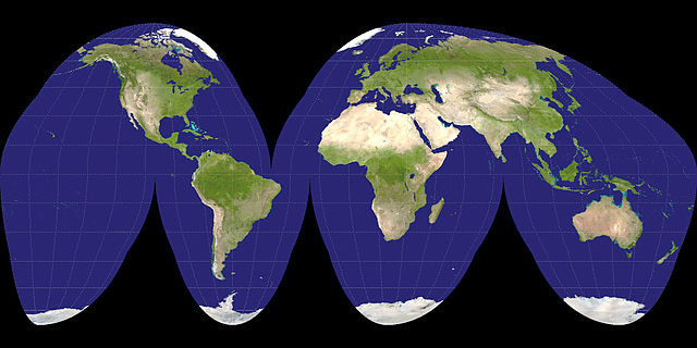
| বিবরণ | A Goode projection of a Visible Earth image collected by the Earth Observatory experiment of the U.S. Government's NASA space agency. The reticle is 15 degrees in latitude and longitude. | ||
| তারিখ | ২৬ অক্টোবর ২০০৫ (Exif উপাত্ত অনুসারে) | ||
| উৎস |
NASA
|
||
| লেখক | NASA |

| এই ফাইলটি পাবলিক ডোমেইনে আছে কারণ এটি শুধুমাত্র নাসা কর্তৃক নির্মিত হয়েছিল। নাসার কপিরাইট নীতি হচ্ছে যে "নাসা কর্তৃক উল্লেখ না থাকলে নাসার উপাদান কপিরাইট দ্বারা সুরক্ষিত নয়"। (Template:PD-USGov, নাসার কপিরাইট নীতির পাতা অথবা জেপিএল চিত্র ব্যবহারের নীতি দেখুন।) | ||
 |
সতর্কবার্তা:
|
ফাইলের ইতিহাস
যেকোনো তারিখ/সময়ে ক্লিক করে দেখুন ফাইলটি তখন কী অবস্থায় ছিল।
| তারিখ/সময় | সংক্ষেপচিত্র | মাত্রা | ব্যবহারকারী | মন্তব্য | |
|---|---|---|---|---|---|
| বর্তমান | ২১:৪৪, ৩ ডিসেম্বর ২০০৬ | | ২,০৪৮ × ১,০২৪ (৪২৫ কিলোবাইট) | Electionworld | {{ew|en|mdf}} A Goode projection of a {{link|Visible Earth}} image collected by the {{link|Earth Observatory}} experiment of the U.S. Government's {{link|NASA}} space agency. The reticle is 15 degrees in latitude and longitude. {{PD-self}} [[Category:Im |
সংযোগসমূহ
নিচের পৃষ্ঠা(গুলো) থেকে এই ছবিতে সংযোগ আছে:
ফাইলের বৈশ্বিক ব্যবহার
নিচের অন্যান্য উইকিগুলো এই ফাইলটি ব্যবহার করে: